

Directions
From Seattle take Highway 2 east to Wenatchee, Highway 97 north to Tonasket, then Highway 20 east to Republic. From Republic take Highway 21 south seven miles to paved Forest Road 53 (Scatter Creek). Travel on FR 53 approximately seven miles to the entrance of Swan Lake Campground. The kitchen area is located at the far end of the campground.
Phone
(509)775-7400
Activities
BIKING, BOATING, CAMPING, FISHING, HIKING, SWIMMING
Keywords
Swan Lake Kitchen,Swan Lake Shelter,Swan Lake Group Site
Related Link(s)
Washington State Road Conditions
Overview
A variety of activities await visitors at the open air Swan Lake Kitchen. Located within the Swan Lake Campground, the group site is situated on a large, flat open space near the beach. The kitchen itself is located up the hill from the beach in the trees. The kitchen is accessible via a staircase from the parking area and a path from the beach. A day of swimming, boating, fishing or hiking can be topped off with a trip to the kitchen to wind down and enjoy a group meal. Originally built in 1936 by the Civilian Conservation Corps, the site was historically preserved in 2009 and retains its charming historic character.
Recreation
Swan Lake has a sandy beach with a swimming dock, plus access to the Swan Lake Trail #14. The trail boasts views of the lake and seasonal huckleberries. Wildlife watching is excellent and the lake is home to loons throughout most of the summer.
Facilities
The covered kitchen comes with several picnic tables, a campfire ring, a stone fireplace, drinking water, vault toilets and garbage containers. The site is suited to groups of 35.
Natural Features
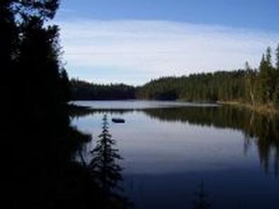
At an elevation of 3,640 feet, Swan Lake Kitchen is located in a wooded area overlooking the 52-acre Swan Lake. The kitchen is on the north end of the lake near the swimming beach.
The 1.1 million acre Colville National Forest lies in the northeast corner of Washington. The forest’s great salmon runs first attracted native Americans to the area, then miners, homesteaders and fur trappers followed. The variety of resources and natural beauty in the region continues to attract visitors.
Nearby Attractions
The Republic Ranger Station and the Stonerose Interpretive Center are 15 miles north in the town of Repbulic.