SOUTH SHORE RECREATION AREA, PA Campground Reservation, Info, Images, Map, Directions

SOUTH SHORE RECREATION AREA, Pennsylvania Campground Images, Info & Reservations

Listen

Directions

From US 15 South, take the Lawrenceville Exit. At the bottom of the ramp, turn right onto State Route 49. Recreation Area will be on the right approxmately 5 miles.

From US 15 North, take the Lawrenceville exit. At the bottom of the ramp turn left. Recreation area will be on the right approximately 5 miles.

Phone

570-835-5281

Activities

BOATING, CAMPING, FISHING, HIKING

Keywords

SOUTH SHORE RECREATION AREA (PA),Cowanesque Lake

Related Link(s)

Rec Area Info & Images

Pennsylvania State Tourism

Pennsylvania State Road Conditions

Overview

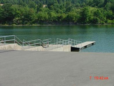
South Shore Recreation Area is located on the south side of the Cowanesque Lake along State Route 49, just five miles west of Lawrenceville, Pennsylvania. The area is easily accessible from Route 15 and offers a great location for boating, picnicking and fishing.

Recreation

Cowanesque Lake offers a variety of outdoor activities including boating and fishing. A variety of native fish inhabits the area’s streams and lakes. The North and South Tailrace areas provide access for fishing below the dam.

The fields and forests around the lake are popular destinations for hunters looking for large and small game species that inhabit the eastern hardwood forests.

Many miles of hiking trails circle the lake, including the Mid State Trail, which travels through the recreation area. It links the trails at Cowanesque and nearby Hammond Lake into a long path that extends all the way through Pennsylvania from Maryland to New York.

Facilities

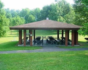
The recreation area offers three group shelters. The Iroquois and Oneida Shelters have electric and water hookups; the Mohawk Shelter has water hookups only. All three sites are fully accessible and comfortably accommodate groups of up to 100 people in a lovely lakeside setting.

Natural Features

Cowanesque Lake is situated in the Endless Mountains region of Pennsylvania, along the Allegheny Plateau in the Appalachian Mountains. The surrounding land paints a scenic picture of rolling terrain and open fields.

Reservation

More from CampingHiking.net:

WEST LAKE, Colorado Campground Images, Info & Reservations

Listen Directions From Fort Collins, take Highway 287 north approximately 24 miles to Livermore. Turn west on County Road 74 and continue 24 miles to the campground. Phone 970-295-6700 Activities BIKING, BOATING, CAMPING, FISHING, HIKING, WILDLIFE VIEWING, CANOEING Keywords WLCO,REDFEATHER LAKES,ARAPAHO AND ROOSEVELT NF – FS Related Link(s) Rec Area

Money Creek Campground, Washington Campground Images, Info & Reservations

Listen Directions From Everett, Washington, take Highway 2 toward Monroe. From Monroe go east approximately 30 miles to campground sign. Turn south and travel a mile to campground. Phone 360-419-5115 Activities BIKING, CAMPING, FISHING, HIKING Keywords MONE,MT. BAKER-SNOQU NF – FS Related Link(s) Rec Area Info & Images Washington State

PLOWMAN CREEK, Texas Campground Images, Info & Reservations

Listen Directions From Kopperl, Texas, travel 1 mile south on FM 56. Follow signs into campground. Phone 254-622-3332 Activities BIKING, BOATING, CAMPING, FISHING, HIKING, HORSEBACK RIDING Keywords PLOW,WHITNEY LAKE,LAKE WHITNEY,WHITNEY LAKE Related Link(s) Rec Area Info & Images Texas State Road Conditions Texas State Tourism Overview PLOWMAN CREEK CAMPGROUND IS

WHISKEY SPRINGS CAMPGROUND, Oregon Campground Images, Info & Reservations

Listen Directions From Butte Falls, OR, take County Rt. 821 south 9 miles to campground sign. Turn left after sign onto Forest Rt. 3065 and go 0.3 miles to another campground sign. Turn left at sign and go 0.3 miles to campground. Phone 541-560-3900 Activities CAMPING, FISHING, HIKING, VISITOR CENTER,

THUNDER RIDGE, Colorado Campground Images, Info & Reservations

Listen Directions From the I-25 and Hwy 24 intersection in Colorado Springs, Colorado, travel west on Highway 24 for 17.4 miles to Baldwin St. in Woodland Park. Turn right (north) on Baldwin (which turns into Rampart Range Road). Travel approximately 3 miles to Loy Creek Road, turn right at the