PORT RAMP MARINA, UT Campground Reservation, Info, Images, Map, Directions

PORT RAMP MARINA, Utah Campground Images, Info & Reservations

Listen

Directions

From I-15, take the Ogden 12th Street exit and travel east on 12th Street to Highway 39 through Ogden Canyon. At the top of the canyon, turn left on Highway 158 which crosses the dam. Travel on Highway 158, past Radford Lane. Port is on the right and is marked with a Forest Service sign.

Phone

OGDEN RANGER DISTRICT 801-625-5112 OR UTAH RECREATION COMPANY 385-273-1100 OR PORT RAMP MARINA 801-745-6390

Activities

BOATING

Keywords

PORT MARINA (UT),Port Ramp,Port Marina,Port,Pineview Ramp,ANDC,PINEVIEW RESERVIOR,WASATCH CACHE,OGDEN,HUNTSVILLE,TRAPPERS LOOP,SOUTH FORK,WASATCH-CACHE NF – FS,Eden

Related Link(s)

Rec Area Info & Images

Forest Service Concessionaire

Utah State Road Conditions

Utah State Tourism

Overview

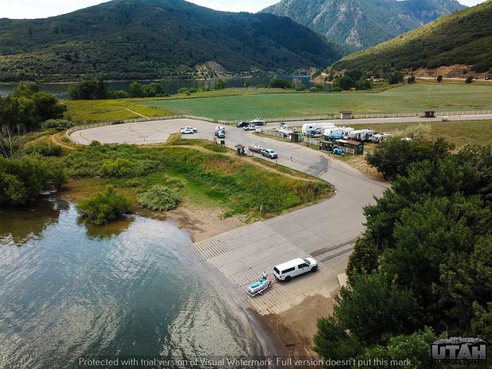
Port Ramp Marina is a boat slip rental facility located just 10 miles from Ogden, Utah, on the west side of Pineview Reservoir in scenic Ogden Valley. The marina is the most used launching facility at Pineview, which is the busiest reservoir in the state.

Recreation

Pineview Reservoir offers spectacular boating, windsurfing, swimming, fishing, and playing in the water and sand.

There are three swim areas with sandy beaches- Cemetery Point west of Huntsville, Anderson Cove Campground and day-use area, and Middle Inlet Beach north of Huntsville.

Facilities

The marina rents boat slips for the entire season, from mid-May through September. The facility has a concrete boat ramp and a large paved parking lot with a designated area for slip holders. An adjacent gravel lot is used for overflow parking and dry storage.

Dry storage can be purchased for a day, month or season. A public dock is on-site. A dump station and vault toilets are located in the paved parking lot. 

Season boat launch pass – $155.00 per vessel, does not apply to day use areas

Season day use pass – $155.00, does not apply to boat launching 

Port ramp parking – $15.00 per vehicle without vessel or per vessel for boat launch

Dry Storage – $350.00/season

Walk-ins – $7.00 per person

Senior and Access Interagency passes do not cover boat launching or day-use. 

Natural Features

Pineview Reservoir lies on the backside of the Wasatch Front. Ogden Valley is comprised of patchwork farmland surrounded by beautiful peaks.

Nearby Attractions

Anderson Cove Campground is located 5 miles away on the south shore of Pineview Reservoir. It offers both family and group campsites and a swimming beach.

Reservation

More from CampingHiking.net:

FUCHS HOUSE, Missouri Campground Images, Info & Reservations

Listen Directions From Poplar Bluff, take Highway 67 north for 14 miles, then drive west on Highway 49 for 9 miles (about 3 miles past the town of Williamsville). Take the first right after crossing the Black River to enter Markham Springs Recreation Area. The drive way to the Fuchs

LAKE THREE, Wisconsin Campground Images, Info & Reservations

Listen Directions 34412 Mineral Lake Rd. (FR 198) From Mellen, Wisconsin; Take County Highway GG west for about 8 miles. Turn right onto Forest Service Road 187/Mineral Lake Road and continue for 3 miles to the intersection with Forest Service Road 198/Pine Stump Corner. Turn right and continue less than

Bedal Campground, Washington Campground Images, Info & Reservations

Listen Directions From Darrington, Washington, travel 16 miles southeast on the graveled single lane section of the Mt. Loop Scenic Byway. The campground is located on the west side of the road at mile post 37, just beyond the junction of Mt. Loop and Forest Road 49. Phone 360-804-1103 Activities

LITTLE CRATER LAKE, Oregon Campground Images, Info & Reservations

Listen Directions From Sandy, travel east on Highway 26 for approximately 40 miles to Skyline Road (Road 42). Turn right and travel south for 4 miles. Turn right on Forest Road 58 and travel 2 miles to the campground. Phone 503-630-5721 Activities HISTORIC & CULTURAL SITE, CAMPING, FISHING, HIKING, WILDLIFE

SEVEN POINTS (TN), Tennessee Campground Images, Info & Reservations

Listen Directions From downtown Nashville, TN, take I-40 east for 7 miles and to exit 221B. Turn right onto Old Hickory Boulevard, then left on Bell Road, right on New Hope Road and left on Stewarts Ferry Pike. Follow the signs to the campground. Phone (615)-889-5198 Activities BOATING, CAMPING, FISHING,

PLATTE RIVER CAMPGROUND, Michigan Campground Images, Info & Reservations

Listen Directions From the east (Traverse City): Take State Highway M-72 west to Empire. Turn south on State Highway M-22. Proceed 10 miles and turn right on Lake Michigan Road. Follow the signs to Platte River Campground. From the south (US-31/M-115): At the junction of U.S. Route 31 and M-115,