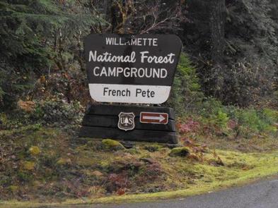
FRENCH PETE CAMPGROUND, OR Campground Reservation, Info, Images, Map, Directions

FRENCH PETE CAMPGROUND, Oregon Campground Images, Info & Reservations

Listen

Directions

From Blue River, Oregon, travel four miles east on Highway 126 to Aufderheide Drive (Forest Service Road 19). Continue on Aufderheide Drive for 11 miles to French Pete Campground.

Phone

801-226-3564

Activities

HIKING

Keywords

Related Link(s)

Rec Area Info & Images

Oregon State Tourism

Forest Service Concessionaire

Oregon State Road Conditions

Overview

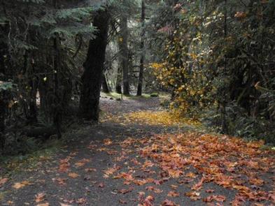
French Pete Campground sits at an elevation of 1,800 feet in the Willamette National Forest. This popular escape from summer heat is heavily shaded by a thick canopy of conifers. There are numerous opportunities for hiking and fishing in the area.

Recreation

The area offers excellent opportunities for fishing, hiking, boating, swimming, camping, picnicking, and scenic drives. Fishing in the McKenzie River is catch and release only for trout. The Three Sisters Wilderness Area as well as French Pete Creek and Box Canyon Trail Areas offer several miles of hiking. Additional hiking trailheads are a short drive away. Terwilliger (Cougar) Hot Springs are nearby for a nice soak. Cougar Reservoir and Hidden Lake are also in the vicinity, offering additional recreation options.

Facilities

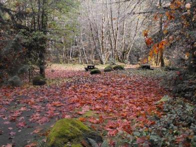
Campsites are nicely shaded with access to both French Pete Creek and the South Fork of the McKenzie River. This 16-unit campground has toilets, water from a hand pump, fire rings, and garbage service.

Natural Features

French Pete Campground sits at the confluence of the South Fork of the McKenzie River and French Pete Creek. The area is heavily wooded with Douglas fir trees and vine maple.

Nearby Attractions

Mountain bike trails, hot springs, a boat ramp and lake accesss are within 10 miles of the campground.

Reservation

More from CampingHiking.net:

MAGRUDER RANGERS HOUSE, Montana Campground Images, Info & Reservations

Listen Directions From Darby, Montana, travel south on Highway 93 for 4 miles to West Fork Road/Highway 473. Continue on this road for approximately 14 miles to the Nez Perce Road/Magruder Corridor Road and go another 34 miles on the one-lane gravel, and partially paved road. Just before the Deep

DONEY CABIN, Montana Campground Images, Info & Reservations

Listen Directions Phone 406-859-3211 Activities BIKING, CAMPING, HIKING, HUNTING, WINTER SPORTS, WILDLIFE VIEWING Keywords DONE,DONEY LAKE CABIN,BEAVERHEAD-DEERLODGE NF -FS Related Link(s) Rec Area Info & Images Montana State Road Conditions Montana State Tourism Overview DUE TO EARTHQUAKE DAMAGE THIS CABIN IS NO LONGER FOR RENT AND IS OFF THE SYSTEM.

ZIPS PLACE CABIN, Montana Campground Images, Info & Reservations

Listen Directions From Hungry Horse, travel east on U.S. Highway 2 for 48 miles, to mile marker 191. Travel south on Geifer Greek/Lodgepole Lane (a gravel road that veers left initially). Follow the signs to the cabin. During the winter months or when the road conditions are impassable, renters must

HURRICANE CREEK, Kentucky Campground Images, Info & Reservations

Listen Directions From Paducah, Kentucky: Take I-24 east to exit 45. Turn right on Highway 293 west and go 0.3 miles. Turn left on Highway 93 south, go 5.3 miles. Turn right on Highway 274 south, go 5.7 miles. Turn right on Hurricane camp road. Campground on left. From Nashville,

JEANETTE LAKE, Minnesota Campground Images, Info & Reservations

Listen Directions From Orr, Minnesota, take St. Louis County Road 23 for 16 miles to Buyck. At Buyck, County Road 23 turns into County Road 24. Continue on County Road 24 for 8 miles to the Echo Trail. Turn right onto the Echo Trail and continue 12 miles to Jeannette

HILLTOP, Nevada Campground Images, Info & Reservations

Listen Directions From Las Vegas, travel north on Highway 95 to the junction with Highway 157/Kyle Canyon. Turn left and travel approximately 17 miles to the junction with Highway 158/Deer Creek. Turn right and travel about 4 miles to the campground on the right side of the road. Phone 702-872-5486