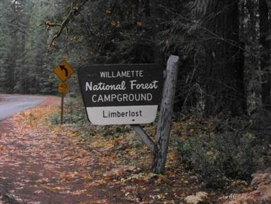
LIMBERLOST CAMPGROUND, OR Campground Reservation, Info, Images, Map, Directions

LIMBERLOST CAMPGROUND, Oregon Campground Images, Info & Reservations

Directions

From McKenzie Bridge, travel east on Hwy 126 to Hwy 242. Follow Hwy 242 approximately 2 miles east to Limberlost Campground.

Phone

801-226-3564

Activities

BIKING, BOATING, HIKING

Keywords

Limberlost Campground

Related Link(s)

Rec Area Info & Images

Forest Service Concessionaire

Oregon State Road Conditions

Oregon State Tourism

Overview

This secluded and quiet campground is nestled along beautiful Lost Creek on the Willamette National Forest. The campgroundâ??s name was derived from "Girl of the Limberlost," a classic novel by American writer and naturalist, Gene Stratton-Porter.

Recreation

Hikers, swimmers, and anglers alike will delight with nearby Three Sisters Wilderness Area, Mt. Washington Wilderness, and Lost Creek. Those interested in relaxing will enjoy a soak in nearby Belknap Hot Springs. If you have an interest in biking, several trails outside of the Wilderness Areas are available.
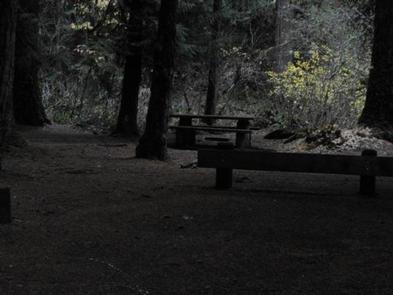
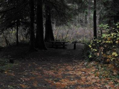
Facilities

The campground offers vault toilets and garbage service. Each campsite includes a fire ring and picnic table. There is no drinking water available at the campground. Firewood is available at Olallie Campground.
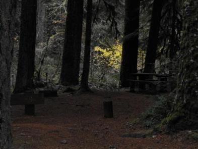
Natural Features

Located near the Three Sisters Wilderness Area, Limberlost is surrounded by fir and cedar forest. The vine maples and thimbleberry in the area help provide privacy and shade for some sites. With the babbling Lost Creek in the background, Limberlost will not disappoint.

Nearby Attractions

Both general stores and restaurants are nearby in the towns of McKenzie Bridge and Blue River.

Reservation

More from CampingHiking.net:

KELSEY CAMPGROUND, Colorado Campground Images, Info & Reservations

Directions From Denver, take Highway 285 southwest to Pine Junction and turn south on Jefferson County Road 126. Travel approximately 17 miles to the campground. Phone 303-275-5610 Activities BIKING, CLIMBING, CAMPING, HIKING, WILDLIFE VIEWING Keywords KELS,PIKE AND SAN ISABEL NF- FS Related Link(s) Rec Area Info & Images Colorado State

BLACK CANYON RIM CAMPGROUND, Arizona Campground Images, Info & Reservations

Directions Located 13 miles west of Heber, Arizona. From Forest Lakes, travel east on Highway 260 for approximately 1 mile. Turn south on Forest Road 300 and travel approximately 2.4 miles. The campground is located at the intersection of Forest Roads 300 and 86. Phone 9285359859 Activities CAMPING Keywords BLACK

Alosa Campsites, Pennsylvania Campground Images, Info & Reservations

Directions Directions From The RiverThe Alosa Campsites are located on the right hand (west) shore of the Delaware River approximately 2.5 miles downstream of Bushkill Access, 1.2 Miles downstream of the Rivers Bend Group Campground (left/east shore of river), and 2,000 feet downstream of Turtle Island, formerly called "Sambo Island".

PINEY CAMPGROUND AND BOAT LAUNCH, Montana Campground Images, Info & Reservations

Directions From Hwy 1 take Georgetown Lake Road over dam. Follow signs; Piney will be 2 miles on your left. Phone 4062108199 Activities BIKING, BOATING, CAMPING, FISHING, HIKING, SWIMMING SITE, SWIMMING, STAR GAZING, WATER ACCESS Keywords Related Link(s) Rec Area Info & Images Montana State Tourism Montana State Road Conditions