WHITEHORSE CAMPGROUND, CA Campground Reservation, Info, Images, Map, Directions

WHITEHORSE CAMPGROUND, California Campground Images, Info & Reservations

Listen

Directions

Physical Address:
Plumas NF – MT. Hough Road
39696 State Highway 70
Quincy, CA 95971

From Quincy: Take Oroville-Quincy Hwy west 15 miles to the campground which will be on your left. If you have a large RV you will need to take Oroville-Quincy Hwy, left onto Big Creek Road, right on Bucks Lake Road, and the campground will be on your right.

From Oroville: Take Oroville-Quincy Hwy 162 East. Left on Bucks Lake Road and campground will be on your right.

Phone

1-530-283-0555

Activities

BOATING, CAMPING

Keywords

WHITEHORSE CAMPGROUND

Related Link(s)

Rec Area Info & Images

California State Tourism

California State Road Conditions

Overview

Whitehorse campground is located within three miles of Bucks Lake in the northern Sierra Mountains on the Plumas National Forest. The Bucks Lake area offers year-round recreation activities including fishing, hiking, snowmobiling, skiing,snowshoeing and horseback riding.

Recreation

Bucks Lake provides fishing, boating, and canoeing. There are walking trails to the lake. A hiking trail runs from the campground and provides access to Buck Wilderness and the Pacific Crest Trail which runs adjacent to the campground.

Facilities

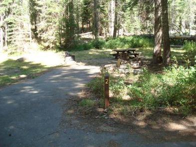
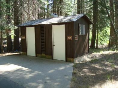
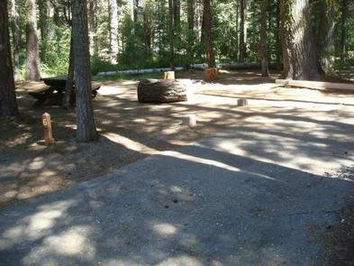
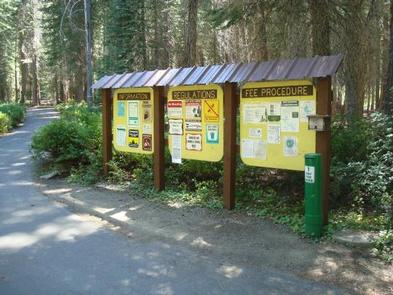
There are 19 total campsites suitable for RV and tent camping, 16 of which are standard non-electric sites and three are equestrian non-electric sites. Each site has a fire ring and picnic table. There are vault toilets and drinking water is available. Sites are walk-up May 24, 2019 thru June 30, 2019. Sites may be reserved July 1, 2019 thru September 8, 2019.

Natural Features

Whitehorse is set in fir and pine trees offering shade during the warm summer months. Situated at 5,500 feet in elevation, the campground is settled along a small creek that feeds into Bucks Lake.

Nearby Attractions

The nearby Bucks Lake Lodge has a bar, restaurant and store offering fishing supplies and groceries.

Reservation

More from CampingHiking.net:

HAMPSHIRE ROCKS, California Campground Images, Info & Reservations

Listen Directions From Truckee, Calif., take Highway 80 west 17 miles. Take the Rainbow/Big Bend exit. If westbound, turn left under the freeway to the campground entrance. If eastbound, turn right at the stop sign. Phone 530-478-6253 Activities BIKING, CAMPING, FISHING, HIKING, SWIMMING, WATER ACCESS, SCENIC DRIVE, HISTORIC SITES Keywords

WALL CREEK CABIN, Montana Campground Images, Info & Reservations

Listen Directions From Ennis, take US Highway south for about 18 miles to Indian Creek and the McAtee Bridge fishing access site. Turn right and go nearly 1 mile to junction just beyond bridge. Turn left and travel toward Wall Creek Wildlife Management Area for 2.7 miles to T junction.

WARRIOR CREEK, North Carolina Campground Images, Info & Reservations

Listen Directions From Winston-Salem, North Carolina, take Highway 421 North (approximately 55 miles) to Exit 286B, turn left onto Highway 268 and continue for approximately 8 miles. Turn right immediately after crossing the bridge and follow signs to the campground. From Charlotte, North Carolina, take I-77 North (approximately 60 miles)

SILVER CREEK-TRUCKEE, California Campground Images, Info & Reservations

Listen Directions From Truckee, travel south on Highway 89 for about 8 miles. Campground is on the left. Phone (530)587-3558. FOR RESERVATIONS, PLEASE CALL: 1 (877) 444-6777. Activities BIKING, CAMPING, FISHING, HIKING, SWIMMING SITE, MOUNTAIN BIKING, WATER ACTIVITIES, WATER ACCESS Keywords SICR,SILVER CREEK TRUCKEE,TAHOE NF – FS Related Link(s) Rec

ASPEN CABIN, Oregon Campground Images, Info & Reservations

Listen Directions From Lakeview, drive 6 miles north on Highway 395 and turn right (east) on Highway 140. Drive for 8 miles on Highway 140 and turn left on Forest Road 3615. Drive 7.5 miles on Forest Road 3615 to arrive at the cabin. The entire route to the cabin