

Directions
From Fresno, CA follow California State Highway 180 East, to its end. Canyon View Campground is on the left (north) side of the road.
Phone
559-565-3341
Activities
BIKING, CAMPING, HIKING, HORSEBACK RIDING, VISITOR CENTER
Keywords
Related Link(s)
National Park Services Concessionaire
California State Road Conditions
Overview
Canyon View Group sites are located in Cedar Grove, Kings Canyon National Park, California. Cedar Grove is located on the South Fork of the Kings River at an elevation of 4,600 feet. This is a TENT ONLY Group Campground. No RV’s or Trailers allowed.
Recreation
Cedar Grove provides some of the best trails in Sequoia and Kings Canyon National Parks, especially near Roads End. Nearby the Kings River offers excellent trout fishing. Horseback riding is also available. Expect warm days and cool nights in the area.
Facilities
There are four large group sites and 12 mid-sized group sites for a total of 16 sites available in the campground that offer picnic tables, fire rings, and bear food storage boxes at each site. All Sites In Canyon View Campground are TENT ONLY, NO RV’s or Trailers. RV’s or Trailers will need to relocate to a different campground where sites may or may not be available to purchase. The campground has flush toilets and drinking water.
There is a small store, snack bar, hotel, showers, and laundry located at the Cedar Grove Village.
Natural Features
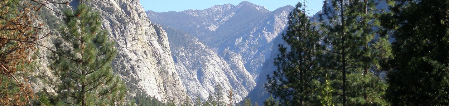
The group sites are located in a cedar and ponderosa pine forest at the bottom of the third deepest canyon in the contiguous United States. The Cedar Grove area’s glaciated valley features towering cliffs, tumbling waterfalls, and the powerful Kings River, whose canyon gave the park its name. Two prominent rock formations, North Dome at 8,717 feet and Grand Sentinel at 8,518 feet, rise 3,500 feet above the canyon floor. Many species of wildlife inhabit the canyon as well.
Nearby Attractions
Boyden Cave, Hume Lake, Grizzly Falls, Mist Falls, Zumwalt Meadow, Roaring River Falls, Sequoia Groves and numerous hiking trails abound in the area. The Cedar Grove Visitor Center offers ranger-led programs including nature and wildlife presentations as well as ranger-led hikes.
The Crystal Caves are about a two and a half hour (72 miles/116 km) from the campground. Reserve tour tickets in advance on Recreation.gov.
Charges & Cancellations
- Payment in full will be charged to your credit card upon completion of the reservation. A $10.00 service fee will apply if you change or cancel your reservation. Additional fees will apply for late cancellations.
- For group campsites: All modifications must be made at least 14 days prior to scheduled arrival date to avoid additional fees.
- For group campsites: All cancellations made within 14 days of the scheduled arrival date are considered late cancellations and will incur the $10.00 service fee and forfeit the first night’s use fee. Cancellations for a single night’s use will forfeit the entire use fee but no cancellation fee will apply.