
Directions
VEHICLE:
Voyageurs National Park is approximately 5 hours north of Minneapolis-St. Paul on I-35 and Hwy 53, 3 hours north of Duluth on Hwy 53, and 4 hours south from Winnipeg, Manitoba.
PLANE:
Falls International Airport is located in International Falls, Minnesota. Taxi service and rental cars are available here. Most flights entering the area will pass through the larger Minneapolis-St. Paul airport located around 5 hours south of Voyageurs National Park.
PUBLIC TRANSPORTATION:
There is no public transportation to Voyageurs National Park. No bus lines or passenger trains serve this area.
Phone
(218) 283-6600
Activities
BOATING, HISTORIC & CULTURAL SITE, CAMPING, INTERPRETIVE PROGRAMS, FISHING, HIKING, PICNICKING, VISITOR CENTER, WILDLIFE VIEWING, WILDERNESS, DAY USE AREA, ENVIRONMENTAL EDUCATION, PHOTOGRAPHY, PADDLING, SWIMMING, KAYAKING, CANOEING, BERRY PICKING, STAR GAZING, BIRDING, CROSS COUNTRY SKIING, WATER SKIING, RECREATION PROGRAMS, SCENIC DRIVE, BACKPACKING, SAILING, TUBING, SNOWSHOEING, SLEDDING, SNOWMOBILE TRAILS, ICE FISHING, ICE SKATING, SNOW TUBING
Keywords
Voya,Voyageurs,Voyaguers,Voyagers,VNP,Rainey,Kabetogama,Namakan
Related Link(s)
Minnesota State Road Conditions
National Geographic Map for Purchase
Overview
Voyageurs National Park has 147 reservable frontcountry campsites and 14 reservable backcountry campsites for those wanting an authentic northwoods camping experience.
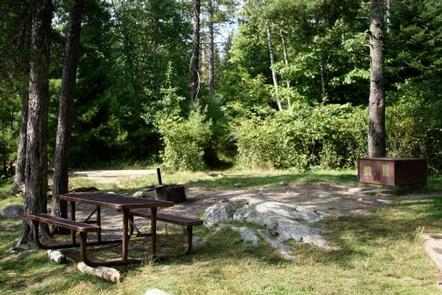
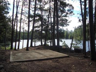
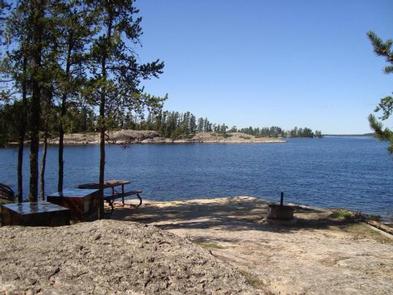
FRONTCOUNTRY CAMPSITES are located on our large lakes (Rainy, Kabetogama, Namakan and Sandpoint) and require travel by watercraft. They are equipped with fire rings, tent pads, picnic tables, bear lockers for safe food storage, and outdoor privies. Click the Build Itinerary button to plan your frontcountry camping trip. View a campsite map here .
BACKCOUNTRY CAMPSITES are located on the park’s interior lakes and offer a more remote and secluded camping experience. These sites come equipped with fire rings, a bear pole for safe food storage, and an outdoor privy. These sites require travel by watercraft to a trailhead and then hiking into the backcountry lakes. From here, some backcountry campsites require a canoe to be reached, while others can be hiked to directly. Please note that Voyageurs National Park only offers canoe rentals on these remote inland lakes; not on Rainy, Kabetogama, Namakan or Sandpoint. Personal water craft or local water taxi service is required to reach the trailheads. For a map of all backcountry sites, click here and scroll to the last map.
BACKCOUNTRY BOAT RENTAL PROGRAM: Voyageurs offers the ability to rent a canoe with a backcountry camping permit at certain campsites. These are located on the remote inland lakes; not on Rainy, Kabetogama, Namakan or Sandpoint. Click the Build Itinerary button to plan your backcountry camping trip.
- Backcountry campsites with canoes available: Locator, War Club, Quill, Loiten, Little Shoepack & Shoepack, Ek, Cruiser, and Brown
- Backcountry campsites with no canoes available (camp-only locations): Agnes, Jorgens, Quarter Line, Oslo, Peary, and Ryan
- Keys to access canoes and paddles must be picked up from a visitor center during business hours.
DAY USE BACKCOUNTRY BOAT RENTALS: Voyageurs offers canoe and rowboat rentals on some backcountry lakes. This requires travel by personal watercraft or local water taxi service to a trailhead, and then hiking into the backcountry lakes where the canoes are located. Click on the Reserve Day Use Rentals button above or scroll further down on this page to view options. Click on the Fees & Cancellation tab to view prices.
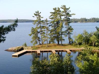
DAY USE & VISITOR DESTINATION SITES: With 27 Day Use sites and 7 Visitor Destination sites scattered throughout, Voyageurs National Park has plenty of areas to enjoy for visitors who are just out for a day trip on the lakes. Each Day Use site has picnic tables, fire rings and vault privies, while the Visitor Destination sites offer short trails with wayside exhibits, picnic areas and comfort stations. No reservations are required for Day Use or Destination sites. View a map of Day Use and Visitor Destination sites here .
Keep Voyageurs National Park Wild for Future Generations: Voyageurs National Park Association (VNPA) is the park’s official nonprofit partner representing a community of people who care about the ongoing stewardship of Voyageurs National Park. VNPA works to fund projects and programs that will help sustain the park’s waters, wild character, and visitor experience for generations to come. Become a member today , follow them on Facebook and Instagram , or sign up for their e-newsletter .
Recreation
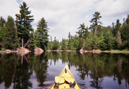
From spring through fall, explore Voyageurs National Park on land by stopping in at a visitor center or hiking any of our 52 miles of scenic hiking trails. To explore the vastness of the same lakes the Voyageurs and Ojibwe Indians once traversed, leave your car behind and explore park waters by kayak, canoe, sailboat, motorboat, houseboat or tour boat. Public boat launch ramps are available at park visitor centers, the Crane Lake ranger station and the two state forest campgrounds – Woodenfrog and Ash River.
With Voyageurs National Park’s scheduled programs and boat tours, you can paddle a canoe on the Voyageurs Highway, watch wildlife by day and stars by night, and explore historic Kettle Falls Hotel, Hoist Bay and Ellsworth Rock Gardens. Check the park website for a current list of these activities and many more, or contact a Voyageurs National Park visitor center and speak with an interpretive park ranger. Reservations in advance are highly recommended for boat tours, which are available on recreation.gov.
Facilities
Voyageurs National Park has three visitor centers, which offer area information, exhibits, a park movie, bookstore, Junior Ranger programs, boat ramps, hiking trials and more. All visitor centers are open daily in the summer, and the Rainy Lake Visitor Center operates year-round.
Raniy Lake Visitor Center (218) 286-5258
Kabetogama Lake Visitor Center (218) 875-2111
Ash River Visitor Center (218) 374-3221
Natural Features
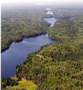
Voyageurs National Park is a land and water environment of great beauty, exceptional natural and cultural resources, and abundant recreational opportunities. Located in the lake-country of northern Minnesota, the park protects 218,054 acres that include roughly 134,000 acres of forest, 84,000 acres of water, 655-miles of undeveloped shoreline, and hundreds of islands. The park’s 55-mile northern boundary is the international border between the United States and Canada and includes an important segment of the “transcontinental highway” traversed by French-Canadian voyageurs during the late 1700s and early 1800s.
The rocks tell the oldest story here. Lying in the southern portion of the Canadian Shield, the bedrock of Voyageurs National Park is 2.8 billion years old, some of the oldest exposed rock in the world. Younger rock formations do not appear here. Perhaps they never existed; but more likely a series of glaciers removed them. Those glaciers, more than a mile high, also scoured out the lake and river beds here and set the stage for vast forests. Voyageurs is unique among national parks as a place where the southern boreal forest meets and mixes with the northern hardwood forest. Wildlife thrives here. Voyageurs is one of only two national parks in the continental United States with an indigenous population of the Eastern timber wolf.
There are four distinct seasons in Voyageur country. The air is temperate during June, July, and August when periods of fine, mild weather prevail. The frost-free season averages 120 days from June to mid-September. The average ice-out date is May 3 but varies year to year. Annual precipitation (rain and snow) averages 25-28 inches in the park and average snowfall ranges from 55-70 inches, but is highly variable. The first measurable snowfall occurs in late October and the last in late April or early May.
Nearby Attractions
Unique attractions near Voyaguers National Park:
The City of International Falls sits on the U.S.-Canada border, across from Fort Frances, Ontario. You can have a picnic lunch in Smokey Bear Park, and then tour the Bronko Nagurski Museam and Koochiching County Historical Museum, which both sit on site. Don’t forget to take a photo with the 26-foot statue of Smokey the Bear himself – a well-known and beloved national symbol of fire prevention and forest conservation. There are many unique businesses and shops along main street, as well as some great coffee shops and restaurants. Heading eastward out of town, you will pass the village of Ranier and numerous resorts where you can find delicious lake-side dining, fishing guides, hotel and cabin accomodations, houseboat rental companies and much more.
The Historic Port Village of Ranier is a quaint little community situated right where Rainy Lake empties into the Rainy River underneath a cantilever-style train bridge that spans from the U.S. into Canada. Here you will find lodging, an RV park, a park and playground, a public beach, public docks, delicous food, an ice cream parlor and a lakeside brewpub, all packed into one small charming town of about 150 residents. Be sure to take a photo with Big Vic, the 25-foot tall statue of a French-Canadian voyageur, who stands at the entrance to this unique little town.
The entrances to the communites of Kabetogama and Ash River are located about 30 miles south of International Falls, and both serve as gateways to the southern district Voyageurs National Park. Be sure to stop and take a photo of yourself “riding” the walleye statue at the entrance to Kabetogama on Highway 53.
Charges & Cancellations
Canellation Policy for 2020 High Use Season (in effect 11/15/19):
Cancellations must be made by phone to recreation.gov. Call the national call center at (877) 444-6777 to cancel a reservation. You cannot call a park office to cancel a reservation.
The following fees apply:
Any change to your reservation more than 3 days prior to your trip: No charge
Any change to your reservation less than 3 days prior to your trip: $10 service fee per call
Cancel reservation more than 3 days prior to arrival date: $10 cancellation fee; receive refund of remaining amenity fees
Cancel reservation less than 3 days prior to arrival date: $10 cancellation fee + forfeit first night€™s fee; receive refund of remaining amenity fees
Once permit has been printed: No refund (printing your permit confirms your reservation and cannot be done until 5 days prior to trip)
Once trip dates have started: No refund