SURRY MOUNTAIN LAKE BEACH, NH Campground Reservation, Info, Images, Map, Directions

SURRY MOUNTAIN LAKE BEACH, New Hampshire Campground Images, Info & Reservations

Listen

Directions

Surry Mountain Lake Beach is located on Route 12A in Surry, New Hampshire.

Phone

603-352-4130

Activities

BOATING, FISHING, HUNTING, PICNICKING, WILDLIFE VIEWING, DAY USE AREA, PHOTOGRAPHY, SWIMMING, KAYAKING, CANOEING, ICE FISHING

Keywords

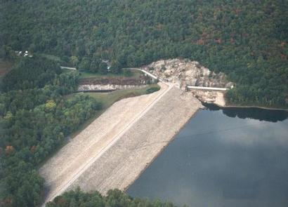
Surry Mountain Lake Beach,Surry Mountain Lake,Surry Mountain Dam

Related Link(s)

Rec Area Info & Images

New Hampshire State Road Conditions

New Hampshire State Tourism

Overview

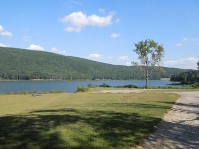
Surry Mountain Lake Beach is a U.S. Army Corps of Engineers day use facility located on the Ashuelot River in Surry, New Hampshire.

Recreation

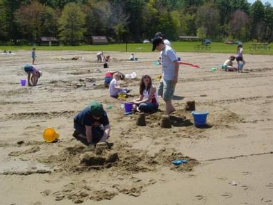
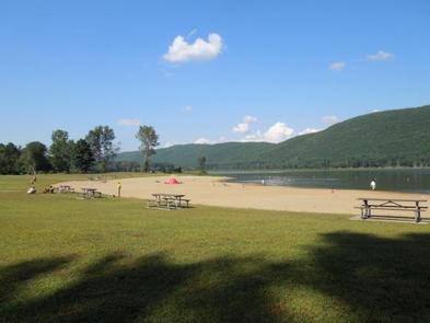
Swimming, sunbathing, picnicking, paddling and fishing are just a few of the favorite activities enjoyed at Surry Mountain Lake Beach. A boat ramp is available for small boats, kayaks and canoes. There are picnic tables and grills located throughout the park, as well as a playground.

Facilities

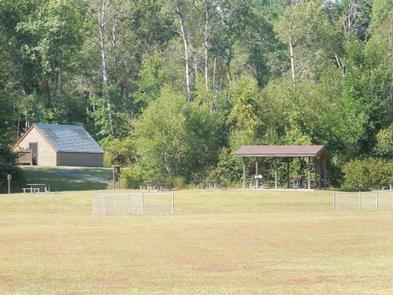
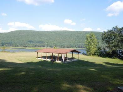
Surry Mountain Lake Beach has restrooms with flush toilets. There is a large sandy beach and swim area. Three picnic shelters are available in the park. Picnic tables, grills a boat ramp and a playground are located in the park.

Natural Features

Surry Mountain Lake Beach provides a large sandy beach on the river and open grassy areas, with views of Surry Mountain.

Charges & Cancellations

If a customer cancels a group day use facility reservation within the 14 days of scheduled arrival date they will forfeit the total fee.

A $10.00 service fee will apply if you change or cancel your reservation outside of the 14 day scheduled arrival. The $10.00 service fee will be deducted from the refund amount.

Reservation

More from CampingHiking.net:

ISLET CAMPGROUND, Oregon Campground Images, Info & Reservations

Listen Directions Located 37.3 miles east of Oakridge, Oregon. From Oakridge, Oregon: At the intersection of Crestview Street and Oregon State Highway 58, travel east on Highway 58 for 23.3 miles. Turn left on the Waldo Lake Road/Forest Road 5897. Travel for 12.8 miles and turn left at the T

Sylvania (Clark Lake) Campground, Michigan Campground Images, Info & Reservations

Listen Directions From Watersmeet, MI, take US 2 west approximately 3.5 miles to County Road 535, turn left onto County Road 535 and travel approximately 3.5 miles to the Sylvania Wilderness Recreation Area entrance on left. Phone 906-396-5428 Activities BIKING, BOATING, CAMPING, FISHING, HIKING, HUNTING, WILDLIFE VIEWING, SWIMMING SITE Keywords

Sand Island Group Sites, Utah Campground Images, Info & Reservations

Listen Directions Sand Island Campground is located on the north bank of the San Juan River about 3 miles west of Bluff, Utah, on the south side of Highway 191. Phone 435-587-1500 Activities HISTORIC & CULTURAL SITE, CAMPING, PICNICKING, PHOTOGRAPHY, PADDLING, WATER ACCESS, WHITEWATER RAFTING Keywords None Related Link(s) Rec

CAPE FAIR, Missouri Campground Images, Info & Reservations

Listen Directions From Reeds Spring, Missouri, head south on Highway 13 for 1.4 miles. Turn West onto Highway 76 and continue for 8 miles to Cape Fair. Turn southwest onto Lake Road 76-82 and follow signs to the campground. Phone 417-538-2220 Activities BIKING, BOATING, CAMPING, FISHING, HIKING, PICNICKING, WATER SPORTS,

NORTH OVERLOOK CAMP, Iowa Campground Images, Info & Reservations

Listen Directions 1007 Hwy T-15 Pella, Iowa From Pella, Iowa, take County Highway T-15 southwest for 3 miles, then follow signs to the campground. Phone 641-828-7522 Activities BIKING, BOATING, CAMPING, FISHING, HIKING, VISITOR CENTER, DAY USE AREA, SWIMMING SITE Keywords NORC,LAKE RED ROCK Related Link(s) Rec Area Info & Images