GRAHAM CORRAL HORSE CAMPGROUND, OR Campground Reservation, Info, Images, Map, Directions

GRAHAM CORRAL HORSE CAMPGROUND, Oregon Campground Images, Info & Reservations

Listen

Directions

From Sisters, OR: Travel 4.2 miles west on Highway 242 (McKenzie Pass Highway), then 2.0 miles north on Forest Road 1012, and then 0.8 miles northwest on Forest Road 1012 300.

Phone

541-323-1746

Activities

CAMPING, HORSEBACK RIDING, HORSE CAMPING

Keywords

Related Link(s)

Rec Area Info & Images

Oregon State Road Conditions

Oregon State Tourism

Overview

Located six miles northwest of Sisters, Oregon, off Highway 20, Graham Corral Horse Camp provides early season access to trails and is perfect for horse lovers who are visiting nearby friends.

Recreation

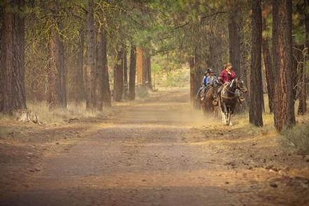
This campground offers many opportunities for horseback riding or hiking on the many trails nearby. The pine forest provides shade as well as the chance to go bird or nature watching.

Facilities

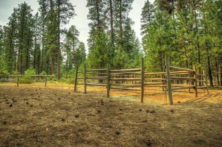
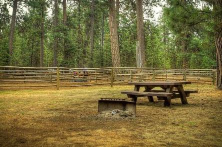
There are 13 sites in this campground. Sites 4, 5, 7, and 8 have four-stall corrals. All other sites share the large corral. Livestock water is available but campers will need to bring their own supply of drinking water.

Natural Features

Graham Corral Horse Camp is nestled below a thick ponderosa pine forest mixed with birch in the wet areas. The pines provide nice shade and the chance to enjoy the quiet of nature.

Nearby Attractions

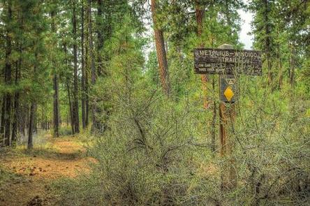
The close proximity to the town of Sisters offers many additional amenities and attractions, as well as the nearby Windigo Trail and numerous trail riding opportunities.

Reservation

More from CampingHiking.net:

PICKENSVILLE CG (PICKENSVILLE AL), Alabama Campground Images, Info & Reservations

Listen Directions From Tuscaloosa, Alabama, take Highway 82 west to the junction with Highway 86. Turn left on 86 west to Pickensville. The entrance road to the campground is 2.5 miles from the yellow caution light. Phone 205-373-6328 Activities BIKING, CAMPING, INTERPRETIVE PROGRAMS, FISHING, HIKING, HUNTING, WILDLIFE VIEWING Keywords PICK,TENNESSEE-

COY FLAT, California Campground Images, Info & Reservations

Listen Directions From Highway 99 go east on 190 to Springville, California. On 190 travel 15 miles to Nelson Drive. From Nelson Drive exit on Coy Flat and drive 1.5 miles to campground. Phone 559-539-5230 Activities CAMPING, FISHING, HIKING Keywords COYF,GIANT SEQUOIA NATIONAL MONUMEN,SEQUOIA NF – FS Related Link(s) Rec

FAWN LAKES CAMPGROUND, New Mexico Campground Images, Info & Reservations

Listen Directions From Red River, drive approximately 3 miles west on NM-38. Phone 435-245-6521 Activities CAMPING, FISHING, HIKING, HOTEL/LODGE/RESORT PRIVATELY OWNED Keywords CARSON NF- FS,Carson National Forest Related Link(s) Rec Area Info & Images Forest Service Concessionaire New Mexico State Road Conditions New Mexico State Tourism Overview Fawn Lakes Campground

OCRACOKE CAMPGROUND, North Carolina Campground Images, Info & Reservations

Listen Directions The campground is located off North Carolina Route 12, three miles east of Ocracoke Village and ten miles west of Hatteras inlet ferry terminal. Phone 252-928-6671 Activities BOATING, CAMPING, FISHING, VISITOR CENTER, SWIMMING SITE Keywords CG04,OCRACOKE Campground,Cape Hatteras National Campgrounds,OCRACOKE,OCRACOKE Related Link(s) Rec Area Info & Images North

RIVER ROAD, Arkansas Campground Images, Info & Reservations

Listen Directions From Ola, Arkansas, take Route 7 south for 9 miles to the Access Road and follow the signs to the campground. Phone 479-272-4835 Activities BOATING, CAMPING, FISHING Keywords RRAR,NIMROD LAKE,PROJECT POINT,NIMROD LAKE Related Link(s) Rec Area Info & Images Arkansas State Tourism Arkansas State Road Conditions Overview River