
Directions
Tully Lake is located in north central Massachusetts, about 1.5 hours west of Boston. In Massachusetts, take exit 17 on Route 2, and follow Route 32 north approximately 6 miles through Athol and into Royalston. From New Hampshire, follow Route 32 south about 8 miles from the intersection of Route 119 in Richmond. Route 32 goes over Tully Dam and provides direct access to the lake.
Phone
978-249-9150
Activities
BIKING, CAMPING, HIKING, WILDLIFE VIEWING
Keywords
Related Link(s)
Massachusetts State Road Conditions
Overview
The U.S. Army Corps of Engineers invites you to come relax at Tully Lake. There are a variety of outdoor recreation activities for you and you family. Although the dam was built primarily to reduce flood damages on the Millers and Connecticut Rivers, the 1,300-acre reservoir area provides a place for you to get away from it all and connect with nature.
Recreation
Tully Lake offers many opportunities to enjoy the outdoors. Activities in and around the lake include mountain biking, camping, disc golf, hiking, picnicking, boating, and fishing and hunting in the appropriate seasons.
Facilities
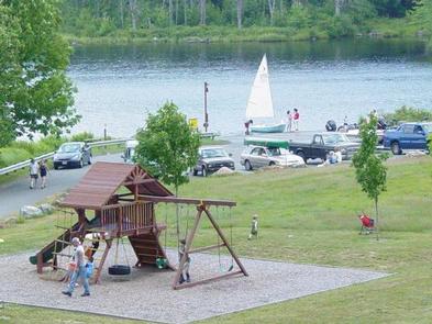
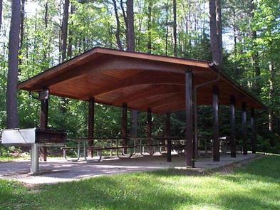
The Tully Lake Pavilion is located in the recreation area and offers picnic tables and grills. Maximum group size is 50 people with parking for 25 passenger vehicles at the upper gravel lot. The recreation area has a small playground for young children, volleyball court, and a horseshoe pit. Bathrooms are provided, but there is no running water.
Natural Features
The 1,262-acre Tully Lake property is managed to sustain a healthy ecosystem for future generations. The thriving biodiversity of the Tully River Valley and the interconnections of our forests, wetlands, waters, and wildlife are valued and managed for the long term. Tully Lake is home to a wide variety of wildlife, from tiny insects and song birds, to large mammals such as deer and moose. Fifty-five percent of the reservoir area is wetlands, providing habitat for fish, waterfowl, song birds, insects, reptiles, amphibians, and mammals such as beaver, mink and otter. The rest of the property provides habitat for upland species such as deer, coyote, fisher, owl, fox, raccoon, skunk, porcupine, rabbit, and squirrel. The forest within Tully Dam’s reservoir area is composed primarily of white pine, providing habitat for owls and woodpeckers, red-tailed hawks, and white-tailed deer.
Nearby Attractions
When visiting Tully Lake there are several opportunities for visitors to explore in the surrounding area. At the north end of the lake there is a tent only campground run by the Trustees of the Reservations which provides a perfect launching point to enjoy the outdoor attractions nearby. Ten miles away is the Birch Hill Dam, another Army Corps project that provides miles of trails and river to explore. The Quabbin Reservoir is also within a short ten mile drive of Tully Lake and serves the city of Boston as its water supply. The Quabbin is a unique area; there were four towns flooded to create it, and it has some of the most interesting blends of human and natural history in the region.
Charges & Cancellations
Please review the cancellation and refund policy at the bottom of the webpage. In general, we will require at least two weeks prior to your reservation to consider a request.