RICHARDSON LAKE CAMPGROUND, WI Campground Reservation, Info, Images, Map, Directions

RICHARDSON LAKE CAMPGROUND, Wisconsin Campground Images, Info & Reservations

Listen

Directions

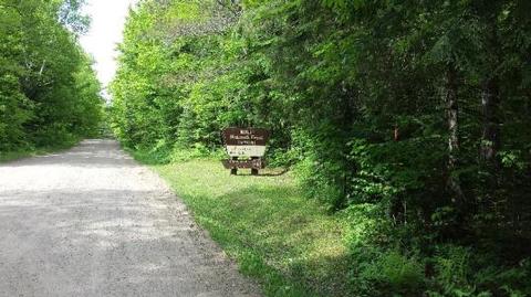
From Wabeno, drive north 0.8 miles on Highway 32 to Highway 52. Turn left (west) on Highway 52 and drive 2.4 miles to Richardson Lake Road (FR2880). Turn right (north) on Richardson Lake Road and continue 0.4 miles to the campground.

Phone

715-674-4481

Activities

CAMPING

Keywords

Related Link(s)

Rec Area Info & Images

Wisconsin State Road Conditions

Wisconsin State Tourism

Overview

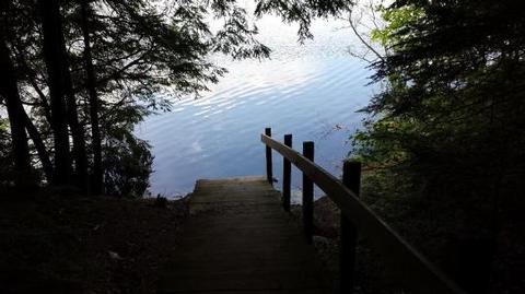
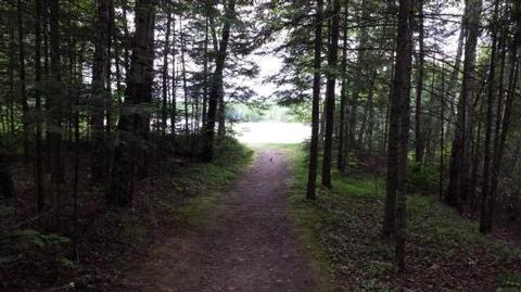
Richardson Lake Campground sits on its namesake lake in beautiful Forest County Wisconsin. This campground’s 26 sites are located on the south shore of Richardson Lake, well known to anglers for its bass, northern pike, and pan fish. Relax on the sandy swim beach or take in the views of the lake from the picnic area above the beach. Take your boat or canoe out on Richardson Lake in search of wildlife along the shoreline.

Recreation

The Chequamegon-Nicolet National Forest has an abundance of outdoor recreation opportunities. Those most enjoyed at Richardson are fishing, swimming, and canoeing.

Facilities

Richardson Lake Campground offers 26 campsites of various sizes that can accommodate tents and RVs. Drinking water, vault toilets, swim beach, and boat landing are also provided at this location.

Natural Features

The campground lies in a lush maple dominated northern hardwood forest on the south shore of 47-acre Richardson Lake. Richardson Lake Campground is best known for its spectacular fall color.

Nearby Attractions

The communities of Wabeno to the east and Crandon to the north offer some services and community events throughout the year.

Reservation

More from CampingHiking.net:

BELOW DAM SOUTH CAROLINA, South Carolina Campground Images, Info & Reservations

Listen Directions The day use area is located just outside Clarks Hill, SC, west off US 221, just below the dam Phone 800-533-3478 Activities BOATING, FISHING, HIKING, PICNICKING, WILDLIFE VIEWING Keywords BDAM,J STROM THURMOND LAKE Related Link(s) Rec Area Info & Images South Carolina State Tourism South Carolina State Road

CARBOLYN PARK, Kansas Campground Images, Info & Reservations

Listen Directions Located 25 miles south of Topeka on US 75. The park entrance is 4.5 miles north of Lyndon, KS on US 75 on the east side of the road. Phone 785-453-2201 Activities CAMPING, PICNICKING Keywords CARB,LAKE POMONA,POMONA LAKE Related Link(s) Rec Area Info & Images Kansas State Road

DOG CREEK (KY), Kentucky Campground Images, Info & Reservations

Listen Directions From Louisville, take I-65 south to exit 76 and turn west onto Highway 224. Continue for 9 miles, then turn left onto Highway 479. After 8 miles make another left onto Highway 88 and continue for about 2 miles to Highway 1015. Turn right and follow signs to

HALF MOON RANCH, Arizona Campground Images, Info & Reservations

Listen Directions From Tucson: Take I-10 east to Exit #318 (Dragoon Road). Turn right onto Dragoon Road and travel for approximately 10 miles through the village of Dragoon to the Cochise Stronghold Road. Turn right on Cochise Stronghold Road and travel for approximately 6 miles to Ironwood Road. The paved

PRAIRIE CREEK (AL), Alabama Campground Images, Info & Reservations

Listen Directions From Montgomery, Alabama, follow Highway 80 west for approximately 25 miles. Turn right on County Road 29 and follow the signs into the campground. Phone 334-418-4919 Activities BIKING, BOATING, CAMPING, FISHING, HIKING, WATER SPORTS, WILDLIFE VIEWING, SWIMMING SITE Keywords PRA1,JONES BLUFF,ALABAMA RIVERS,WOODRUFF,ROBERT F. HENRY,ROBERT F HENRY,ALABAMA RIV. –