
Directions
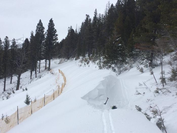
The lookout is located approximately 16 miles southeast of Lincoln. It can be reached via Stemple Pass Road #601, which leaves downtown Lincoln at the blinking light and joins Highway 279 north of Helena. Follow Stemple Pass Road for approximately 14 miles to the top of the pass and then turn onto Marsh Creek Road #485. Follow Marsh Creek Road south approximately 3 miles until the junction of the Granite Butte Road #4133. The road gets narrower and rougher at this point and climbs the final 1.5 miles up to the lookout tower. High clearance vehicles are strongly recommended for the Granite Butte Road #4133. During the winter months, the Stemple Pass Road is plowed in its entirety, but visitors will have to snowmobile or ski in the final 4.5 miles. There is plowed parking available at the Stemple Pass cross country ski area. There are two recommended routes into the lookout. One follows the road as outlined above and the other roughly follows the Continental Divide. If you are planning on snowmobiling into the lookout in the later winter months it is recommended that you take the upper route on the Continental Divide as the Marsh Creek Road develops large wind drifts that are generally impassable by snowmobiles. Please be sure to follow all applicable motorized use restrictions when accessing the lookout and only operate motorized vehicles where allowed. Maps of the ski and snowmobile routes are available at the Lincoln Ranger District and at the Stemple Pass Trailhead. Renters are advised to take a map with them if they are unfamiliar with the area.
Phone
406-362-7000
Activities
CAMPING, HIKING, HUNTING, WILDLIFE VIEWING, FIRE LOOKOUTS/CABINS OVERNIGHT, SNOWMOBILE, CROSS COUNTRY SKIING, SCENIC DRIVE, SNOWSHOEING
Keywords
Related Link(s)
Overview
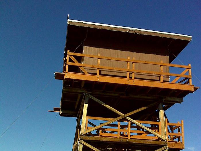
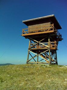
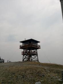
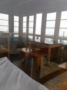
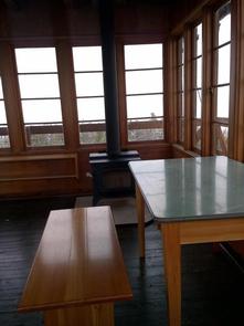
The Granite Butte Lookout is located at 7,587 feet above sea level atop the Continental Divide of North America. The 15′ by 15′ lookout cabin sits atop a 20′ tall wooden tower that was first built in 1932. The structure was rebuilt in 1962 and has been recently renovated. This tower was listed on the national register of historic lookouts in 2008 and offers guests a glimpse into the life of a Forest Service Lookout. Located near Lincoln, MT the lookout offers direct access to the Continental Divide National Scenic Trail which stretches along the back bone of the continent from Canada to Mexico. It is accessible by vehicle, but be forewarned, the road is rough towards the end and high-clearance vehicles are recommended. The lookout has the basic amenities including a bed, auxiliary cots, tables, chairs, dishes, cutlery, and a woodstove are provided, but guests should prepare to bring their own bedding, water, and propane.
Recreation
The Continental Divide Trail passes right by the lookout tower and offers guests access to as many miles as they care to hike, bike, or ride on horseback. There are several other trails for guests to explore within a 1/2 hour drive. The cabin also offers winter recreation opportunities with cross-country skiing opportunities out the back door and nearby access to over 200 miles of groomed snowmobile trails.
Facilities
The lookout is furnished with one twin bed with a mattress and three twin cots. The lookout can accommodate a maximum of four people. The lookout is equipped with a table, chairs, woodstove, propane cook stove, propane powered lanterns, silverware and dishes. An axe and splitting maul are available for splitting wood and firewood will usually be stacked at the base of the tower, but it is not guaranteed. The lookout does not have electricity or indoor plumbing. A vault toilet is on-site near the lookout. Guests will need to bring their own water for drinking and washing. Guests are advised to bring sleeping bags, linens, towels, dish soap, matches, propane, garbage bags and other personal effects. All garbage must be packed out and guests are expected to clean the cabin before leaving. A broom and cleaning supplies are provided.
Natural Features
The lookout is located atop a grassy ridge directly on the Continental Divide. The area around the cabin offers spectacular views, abundant wildflowers, high elevation white bark pine stands, open meadows, and large rock outcroppings. There are lower elevation conifer stands and streams located nearby as well.
Wildlife in the area abounds; including the more common elk, mule and white-tailed deer, squirrel, black bear, and a variety of birds. The more elusive grizzly bear, badger, wolverine, mountain lion, and lynx can be found here as well.
Nearby Attractions
The nearby town of Lincoln offers restaurants, bars, art galleries, a sculpture park, and many events that are put on in the community throughout the summer. Visitors can also access the scenic Blackfoot River and Copper Creek from town and the nearby area.