NORTH TWIN LAKE CAMPGROUND, Oregon Campground Reservation, Info, Images, Map, Directions

NORTH TWIN LAKE CAMPGROUND, Oregon Campground Images, Info & Reservations

Listen

Directions

From Bend, OR: Travel 26.8 miles south on Highway 97 to Wickiup Junction, then 11.0 miles west on County Road 43, then continue 4.6 miles west on County Road 42, and finally 0.2 miles south on County Road 4260.

Phone

541-383-5300

Activities

CAMPING

Keywords

Related Link(s)

Rec Area Info & Images

Oregon State Tourism

Oregon State Road Conditions

Overview

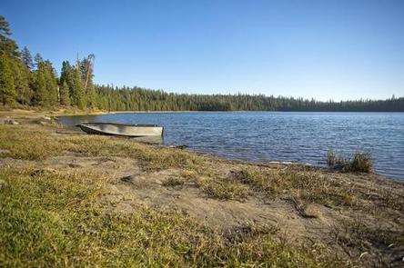
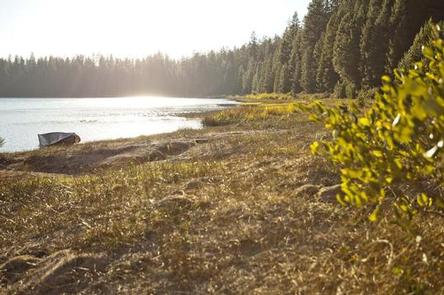
North Twin Lake Campground islocated just north of the South Twin Resort on North Twin Lake.

Recreation

Located on North Twin Lake, this campground offers a small beach at the shallow end of the lake that is great for wading and swimming. Fishing is also quite popular though motorized boats are prohibited on this body of water.

Facilities

North Twin Lake Campground can accommodate RV, trailer or tent-campers, however, water and electric hookups are not available. Campers will need to bring their own water supply. All sites are equipped with a picnic table and campfire ring with grill and the campground has vault toilets available. There is an RV dump station just after the entry of the nearby Gull Point Campground

Natural Features

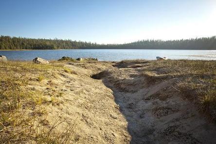
North Twin Lake was formed about 20,000 years ago when rising magma encountered groundwater. This resulted in violent steam explosions which formed a broad shallow crater that later filled with water. Nearby peaks, lava flows and old-growth forests provide visitors with a varied landscape.

Nearby Attractions

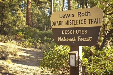
Twin Lakes Trail #5.1 is an interpretive trail leaving the campground near the water that informs visitors about “dwarf mistletoe” infecting the ponderosa pine trees in the area.

Visitors can explore wilderness areas, rivers, lakes and reservoirs, and approximately hundred of miles of trail. Newberry National Volcanic Monument, approxiately 45 minutes by vehicle, is a great starting point for visitors to learn about the diverse landscape and history of the area through interpretive programs and exhibits. Visitors can explore Lava River Cave, the longest continuous lava tube in Oregon. Visitors enjoy traveling the Cascade Lakes Scenic Bywaywhich climbs 66 miles through the Cascade Range, weaving past snow-capped peaks and alpine lakes.

Reservation

More from CampingHiking.net:

Soda Springs Campground, Washington Campground Images, Info & Reservations

Listen Directions Take Highway 410 to milepost 88.4, then turn left on Bumping Lake Road and continue for 5 miles to the campground. Phone 541-338-7869 Activities CAMPING, FISHING, HIKING, WATER SPORTS Keywords SOSP,Bumping River,OKANOGAN – WENATCHEE NF -FS Related Link(s) Rec Area Info & Images Washington State Tourism Washington State

TWOGOOD CABIN, Montana Campground Images, Info & Reservations

Listen Directions From Missoula, Montana, travel south on Highway 93 to Medicine Creek Road/Forest Service Road 370, which is approximately 36 miles south of Hamilton. Turn right and continue about 4 miles to the trailhead, which is located at Crazy Creek Campground. An easy, 6-mile hike leads to the cabin

BLUE BAY, Oregon Campground Images, Info & Reservations

Listen Directions From Sisters, travel approximately 13 miles northwest on Highway 20/126. Turn left onto Forest Road 2070 (Suttle Lake Campgrounds). Travel just less than 1/2-mile to Blue Bay entrance on the right. Phone 541-323-1746 Activities BOATING, CAMPING, INTERPRETIVE PROGRAMS, FISHING, HIKING Keywords BLBA,SUTTLE LAKE CAMPGROUND,DESCHUTES NF – FS Related

PIEDMONT PARK, Missouri Campground Images, Info & Reservations

Listen Directions From Piedmont, MO, follow Missouri State Highway HH. Travel on Highway HH for 6 miles to the top of the dam. Turn right and follow signs into campground. Phone 573-223-7777 (CLEARWATER LAKE PROJECT OFFICE) 573-223-4432 (PIEDMONT PARK GATE HOUSE) Activities BOATING, CAMPING, SWIMMING SITE Keywords PIED,CLEARWATER LAKE,PIEDMONT,PARK ABOVE

SOUTH SANDUSKY CAMPGROUND, Illinois Campground Images, Info & Reservations

Listen Directions From I-57 take exit 71 and turn west onto Route 14. After 3 miles turn right on Rend City Road, then continue for 6 miles to the campground entrance on the right. Phone 618-724-2493 Activities BIKING, CAMPING, INTERPRETIVE PROGRAMS, FISHING, HIKING, WILDLIFE VIEWING, SWIMMING SITE, STAR GAZING Keywords

BIG HANK, Idaho Campground Images, Info & Reservations

Listen Directions From Kingston on I-90, take Exit 43 to FH-9 and drive 20 miles north to Prichard, then turn left and continue 17 miles north on FH Road 208 to campground. Phone 435-245-6521 Activities BIKING, CAMPING, FISHING, HIKING, SWIMMING SITE, BIRDING Keywords BHAN,IDAHO PANHANDLE NF – FS Related Link(s)