MONTY CAMPGROUND, OR Campground Reservation, Info, Images, Map, Directions

MONTY CAMPGROUND, Oregon Campground Images, Info & Reservations

Listen

Directions

From Sisters, OR: Travel 5.6 miles northwest on Highway 20, then 20.8 miles north on Forest Road 11, then 5.0 miles east on Forest Road 1170, and then 7.2 miles northwest on County Road 64.

Phone

503-464-8515

Activities

CAMPING, FISHING, WILDLIFE VIEWING

Keywords

Related Link(s)

Rec Area Info & Images

Oregon State Road Conditions

Oregon State Tourism

Overview

Monty Campground is located on the lower Metolius River just above Lake Billy Chinook and offers fishing and a peaceful setting.

Recreation

Fishing tops the list of recreational activities for visitors.

Water enthusiasts of all types will enjoy the opportunities available at nearby Perry South Campground. Motorized and non-motorized boats share the vicinity with swimmers and water skiers braving the cold, clear waters of Lake Billy Chinook.

Facilities

Monty Campground can accommodate small RV, trailer or tent-campers however it is best suited for tent camping as electric hookups are not available and the access roads can be very rough. RV and trailer campers are cautioned to take it slow and steady. All sites are equipped with a picnic table and campfire ring with grill and vault toilets are available. You must bring your own drinking water.

Natural Features

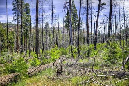
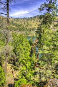
Lake Billy Chinook is the highlight of the area. Created by Round Butte Dam, it fills the canyons of the Crooked, Metolius and Deschutes Rivers. Within these three large arms are 72 miles of shoreline, supporting fish habitats for bass, trout, salmon, whitefish, suckers, minnows and dace. Rugged hills and a diverse coniferous forest surround the lake, providing homes for mammals such as mule deer, coyote, black-tailed jackrabbit and cougars.

Nearby Attractions

Visitors may want to explore the Tam-a-lau Trail, a scenic hike that starts on a peninsula at the confluence of the Crooked River and the Deschutes River in Cove Palisades State Park.

Under the designation of a Wild and Scenic River, nearby Metolius River is nestled in a forested valley west of Mt. Jefferson. It’s clear, cold and constant waters support fly-fishing and whitewater boating.

Lava Lands Visitor Center in nearby Bend, Oregon, offers visitors the opportunity to learn about the diverse landscape and history of the area through interpretive programs and exhibits.

Charges & Cancellations

A service fee will apply if you change or cancel your reservation. Late cancellations are subject to additional fees. For full details see the Recreation.Gov, Rules & Reservation Policies.

Reservation

More from CampingHiking.net:

INDIAN CREEK CAMPGROUND (CA), Nevada Campground Images, Info & Reservations

Listen Directions From Woodfords, California, travel Hwy 89 south approximately four (4) miles to Airport Road. Turn left or east on Airport Road and travel another four miles on paved surface to the campground entrance located just south of Indian Creek Reservoir. Phone (775) 885-6000 Activities AUTO TOURING, BIKING, BOATING,

JORDAN PINES, Utah Campground Images, Info & Reservations

Listen Directions From I-215, take the 6200 south exit and travel a mile east to Wasatch Blvd. Take Wasatch Blvd a mile south to junction with Big Cottonwood Canyon/Highway 190. Make a left at the junction and travel up Big Cottonwood Canyon 9.2 miles to the campground. Phone SALT LAKE

PLATTE RIVER CAMPGROUND, Michigan Campground Images, Info & Reservations

Listen Directions From the east (Traverse City): Take State Highway M-72 west to Empire. Turn south on State Highway M-22. Proceed 10 miles and turn right on Lake Michigan Road. Follow the signs to Platte River Campground. From the south (US-31/M-115): At the junction of U.S. Route 31 and M-115,

HAWTHORN BLUFF, Oklahoma Campground Images, Info & Reservations

Listen Directions From Tulsa, Oklahoma, take U.S. Highway 169 north for 27 miles to Highway 88. The campground is 2 miles east of the town of Oologah on Highway 88. Phone 918-443-2319 Activities BOATING, CAMPING, FISHING, HIKING, VISITOR CENTER, WATER SPORTS, DAY USE AREA, SWIMMING SITE Keywords HAWT,OOLOGAH LAKE,OOLOGAH LAKE

RIVERSIDE (ID – TARGHEE), Idaho Campground Images, Info & Reservations

Listen Directions From Ashton, Idaho, travel north on Highway 20 for 15 miles, take Riverside Campground turnoff, travel 1 mile to the campground entrance. Phone 208-558-7658 OR 208-270-0094 Activities CAMPING, FISHING, WILDLIFE VIEWING Keywords RIV1,RIVERSIDE TARGHEE,CARIBOU-TARGHEE NF – FS Related Link(s) Rec Area Info & Images Idaho State Road Conditions

WATSADLER, Georgia Campground Images, Info & Reservations

Listen Directions Watsadler Campground Address: 286 Watsadler Road, Hartwell, Ga 30643. From I-85 North in Georgia, take exit 177 onto Highway 77 towards Hartwell, Georgia. In Hartwell, take Hwy 29 North towards Anderson, South Carolina. Continue approximately 4 miles, take a Left onto Watsadler Road; entrance will be a short