NORTHBANK DAY USE AREA SHELTER, GA Campground Reservation, Info, Images, Map, Directions

NORTHBANK DAY USE AREA SHELTER, Georgia Campground Images, Info & Reservations

Directions

From Atlanta: Take Interstate 75 North until Exit 293, turn right onto Georgia Highway 411 North, travel approximately 30 miles; take a right onto Georgia Highway 136 East; proceed across approximately 2 miles; turn left onto Carters Dam Road; continue almost 2 miles and proceed straight into Northbank Day Use Area.

Northbank
2800 Carters Dam Road
Chatsworth, GA 30705

Phone

706-334-2248

Activities

HIKING, DAY USE AREA, KAYAKING, CANOEING

Keywords

Related Link(s)

Rec Area Info & Images

Georgia State Tourism

Georgia State Road Conditions

Overview

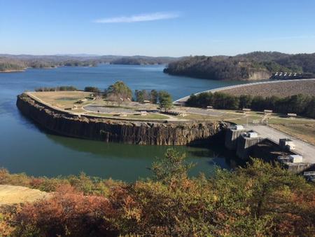
Northbank Day Use Area is located in the North Georgia Mountains about 70 miles north of Atlanta on Carters Lake. The sparkling waters and rugged shoreline provide a beautiful surrounding for a variety of outdoor recreational opportunities including camping, hiking, boating, mountain biking, fishing, hunting and picnicking. Norhtbank provides an excellent view of both Carters Lake and the ReReg Lake from its location on top of Carters Dam.

Recreation

Northbank provides multiple recreation opportunities including fishing, hiking trails, basketball, volleyball and sightseeing.

Facilities

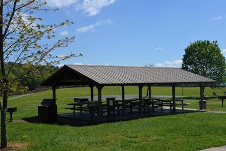
Northbank Day Use Area provides visitors with panoramic views of Carters Lake along with ample picnic sites, restrooms, a playground, volleyball court, basketball court and horseshoe pits. The large shelter (CL-13) seating capacity is 100 people maximum and parking capacity of 50 vehicles. The small shelter (CL-9) seating capacity is 50 people maximum and parking capacity of 25 vehicles.

Natural Features

Carters Lake embraces a spectacular tract of foothills scenery in the Blue Ridge Mountains of North Georgia. It covers 3,200 surface acres and has 62 miles of undeveloped shoreline. Boaters visit Carters Lake to enjoy its solitude and scenic beauty.

Nearby Attractions

The Cities of Ellijay and Chatsworth are about 30 minutes away offering restaurants, grocery stores and fuel, along with other amenities.

Charges & Cancellations

Please review the rules and reservation policies at the bottom of the page.

Reservation

More from CampingHiking.net:

WILLOW FLAT CAMPGROUND, Utah Campground Images, Info & Reservations

Directions From Preston, Idaho, head south on U.S. Highway 91 for approximately 3 miles. Turn east on the Cub River Road (Forest Road 406) and travel 3 miles past the Cache National Forest boundary to the intersection of Forest Road 406 and Forest Road 407. Bear right at the intersection,

CHILHOWEE CAMPGROUND, Tennessee Campground Images, Info & Reservations

Directions The campground is located on FDR 77/Oswald Dome Road. Be Aware; Do not use GPS directions: GPS coordinates will direct you up Benton Springs Rd. This route is not recommended. We recommend using Forest Service Road 77 to reach the recreation area. It’s important to note, this facility requires

ROCKY CREEK (SOMERVILLE LAKE), Texas Campground Images, Info & Reservations

Directions From Austin, Texas, take US 290 east to Brenham. Follow HWY 36 north 11.5 miles to FM 1948. Turn left on FM 1948 and follow 5 miles to the park entrance. Phone 979-596-1622; FOR BOOKING, CALL 1-877-444-6777 Activities BOATING, CAMPING, FISHING Keywords ROC2,SOMERVILLE LAKE,LAKE SOMERVILLE,ROCKY CREEK SOMERVILLE LAKE,SOMERVILLE LAKE

COTTONWOOD CAMPGROUND (WA), Washington Campground Images, Info & Reservations

Directions From Naches, take Highway 410 northeast 22.5 miles to milepost 99.5. Phone 541-338-7869 Activities CAMPING, FISHING, HIKING, WATER SPORTS Keywords CTWD,OKANOGAN – WENATCHEE NF -FS,COTTONWOOD,COTTONWOOD CAMPGROUND Related Link(s) Rec Area Info & Images Washington State Tourism Washington State Road Conditions Forest Service Concessionaire Overview Cottonwood Campground is located along

TWIN LAKE CAMPGROUND, Utah Campground Images, Info & Reservations

Directions Travel east out of Mayfield, UT on "Canyon Road" to the Forest Service boundary of Twelve Mile Canyon. Stay on Forest Development Road 22, approximately 7.5 miles from Mayfield. Phone 435-283-4151 Activities CAMPING Keywords None Related Link(s) Rec Area Info & Images Utah State Tourism Utah State Road Conditions