Directions
From Needles, CA, take U.S. Highway 95 south approx. 20 miles to Havasu Lake Road. Turn left on Havasu Lake Road and drive approx. 5 miles to BLM Route NS683 – Parker to Needles Wagon Road. Turn right on NS683 and drive approx. 10 miles to BLM Route NS520. Turn left on NS520 and drive approx. 2 miles. A wilderness kiosk sign will be on your right hand side.
Phone
760-326-7000
Activities
CAMPING, HIKING, HUNTING, WILDLIFE VIEWING, WILDERNESS, PHOTOGRAPHY, HORSE CAMPING
Camping Reservations
Reserve your campsite at these camping areas:
Hiking Trails
Looking for nice hiking areas to take a hike? Choose from these scenic hiking trails:
Related Link(s)
More California Recreation Areas
Whipple Mountains Wilderness Map
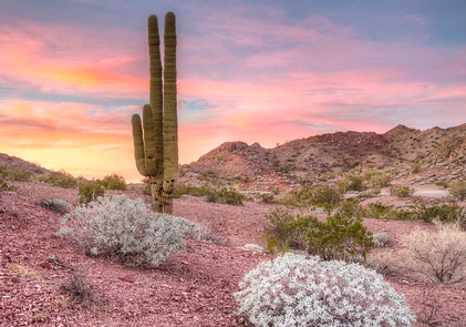
The large east-west oriented Whipple Mountains comprise the dominant land form within this wilderness. Whipple Peak is the highest point in the range at an elevation of 4,131 ft. Landforms are diverse and range from valley floors and washes to steep-walled canyons, domed peaks, natural bridges, and eroded spires.
Two major vegetative associations are present within the wilderness area, the Sonora creosote bush scrub and Sonoran thorn forest. Dominant vegetation is creosote bush scrub, palo verde, ironwood, smoke tree, and numerous species of cacti including cholla, saguaro, foxtail, and prickly pear.
Wildlife species include bighorn sheep, mule deer, wild burros, coyote, black-tailed jackrabbits, ground squirrels, kangaroo rats, quail, roadrunners, owls, the threatened desert tortoise, and several species of rattlesnakes and lizards. The Whipple Mountains provide superior nesting and foraging habitat for a number of raptors; including prairie falcons, golden eagles, red-tailed hawks, and Cooper’s hawks. The wilderness is located in the south eastern corner of the sector and consists of 77,520 acres. It is cooperatively managed with the Havasu Field Office.