Directions
This wilderness is in southwest Maricopa County, 11 miles northwest of Gila Bend and 32 miles southwest of Phoenix, Arizona. Accessible via old U.S. Highway 80 and Enterprise Road south of Arlington, via various jeep trails extending south from the Aqua Caliente Road, and via Interstate 8 and the Painted Rocks Dam Road west of Gila Bend. It is adjacent to the 13,350-acre Signal Mountain Wilderness.
Phone
(623) 580-5500
Activities
HIKING, HORSEBACK RIDING, WILDERNESS
Camping Reservations
Reserve your campsite at these camping areas:
Hiking Trails
Looking for nice hiking areas to take a hike? Choose from these scenic hiking trails:
Related Link(s)
Overview
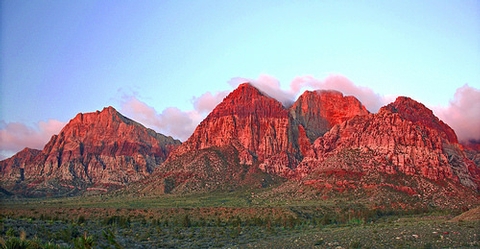
Congress added the Woolsey Peak portion of the Gila Bend Mountains to the National Wilderness Preservation System in 1990, citing the rugged topography, colorful scenic vistas, rich variety of wildlife and vegetation, and outstanding opportunitiesfor solitude and unconfined recreation in both areas. This 64,000-acre wilderness area is a perfect example of pristine Sonoran Desert.
Rising 2,500 feet to an elevation of 3,270 feet, Woolsey Peak is a prominent and scenic landmark of southwestern Arizona. Large washes, lined by thick stands of paloverde and ironwood, wind through sparsely vegetated, rock-strewn hills and desert plains below the major peaks. Wildlife includes mule deer, bighorn sheep, javelina, and numerous varieties of birds, lizards, and snakes. This wilderness area offers outstanding opportunities for cross-country foot and horseback travel, route finding, and wildlife viewing. There are no marked trails, campsites, or other developed recreational amenities — this area is recommended only for experienced and prepared wilderness visitors!
Know Before You Go
- In wilderness, you can enjoy challenging recreational activities and extraordinary opportunities for solitude. Please follow the regulations in place for this area, and use Leave No Trace techniques when visiting to ensure protection of its unique natural and experiential qualities.
- Motorized equipment and equipment used for mechanical transport are generally prohibited on all federal lands designated as wilderness. This includes the use of motor vehicles (including OHVs), motorboats, bicycles, hang gliders, wagons, carts, portage wheels, and the landing of aircraft including helicopters Contact the agency for more information about regulations.
- High-clearance vehicles are needed and four-wheel drive vehicles are recommended, except for portions of the Enterprise Road south of Gillespie Dam.
- Some lands around and within the wilderness are not federally administered. Please respect the property rights of the owners and do not cross or use these lands without their permission.