


Directions
Moores Creek National Battlefield is located 20 miles NW of Wilmington, North Carolina. · From Highway 17, follow US 421 to NC 210, then West on NC 210 · From Interstate 40, take exit 408 (NC 210) West at Rocky Point. · From Interstate 95 North, take exit 13-A for NC 74 East towards Wilmington. · From Interstate 95 South: take exit 81-B for I-40 East towards Wilmington. · From Fayetteville, North Carolina, take Interstate 95 South to Exit 13-A Questions please call us as 910-283-5591 x2234
Phone
(910) 283-5591
Activities
HISTORIC & CULTURAL SITE, FISHING
Camping Reservations
Reserve your campsite at these camping areas:
Hiking Trails
Looking for nice hiking areas to take a hike? Choose from these scenic hiking trails:
Related Link(s)
More North Carolina Recreation Areas
Moores Creek National Battlefield Official Website
Moores Creek National Battlefield Map
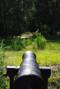
In the early morning hours of February 27, 1776 Loyalist forces charged across a partially dismantled Moores Creek Bridge. Beyond the bridge, nearly 1,000 North Carolina Patriots waited quietly with cannons and muskets poised to fire. This battle marked the last broadsword charge by Scottish Highlanders and the first significant victory for the Patriots in the American Revolution.