WHITE STAR, CO Campground Reservation, Info, Images, Map, Directions

WHITE STAR, Colorado Campground Images, Info & Reservations

Listen

Directions

From Leadville, travel 15 miles south on Highway 24 to Highway 82. Turn right and go west 5.5 miles on Highway 82, turn left into the White Star Campground.

Phone

719-486-0749 (FOR INFORMATION ONLY, NO RESERVATIONS)

Activities

BOATING, CAMPING, FISHING, HIKING, MOUNTAIN BIKING

Keywords

WSTR,TWIN LAKES,PIKE AND SAN ISABEL NF- FS,whitestar

Related Link(s)

Rec Area Info & Images

Colorado State Tourism

Forest Service Concessionaire

Colorado State Road Conditions

Overview

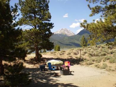
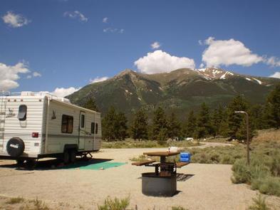
Picturesque White Star Campground lies at the foot of Mt. Elbert, Colorado’s highest peak, among fragrant ponderosa pines. The campground provides convenient access to Twin Lakes Reservoir for plenty of water recreation opportunities. It also works as a base camp for hikers and mountain bikers who love to explore nearby trails such the Continental Divide National Scenic Trail and the Mount Elbert Trail.

Recreation

The Continental Divide Trail, which runs from Canada to Mexico, passes by the White Star Campground. The hiking trail is open to mountain bikes in the section from Halfmoon Road South to Twin Lakes. About 300 miles of the trail is within Colorado’s borders.

Twin Lakes are Colorado’s largest natural glacial lakes, and sailing and water skiing are among the popular activities there. Fishing includes lake, rainbow and Mackinaw trout.

Facilities

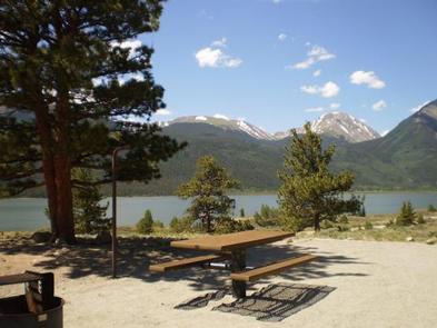
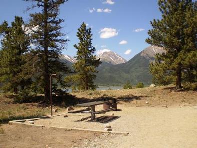
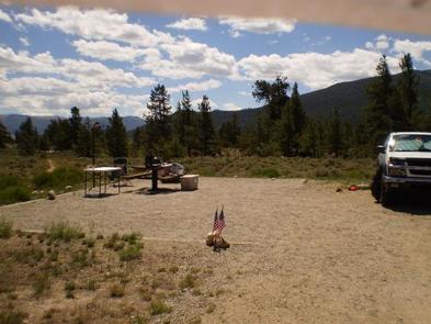
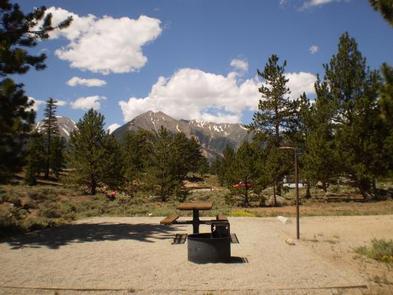
White Star Campground is comprised of three loops. Sage Loop has limited shade, and Ridge and Valley Loops have a somewhat greater density of ponderosa pine and spruce trees. Drinking water is available through a pressurized water system and vault toilets are located throughout the campground. A boat ramp, parking, and angler fishing areas are located just down the road from the campground. Firewood is for sale at the camp host site.

Natural Features

The campground, at an elevation of 9,200 feet, sits on the north side of the Twin Lakes Reservoir near the base of Mount Elbert. The Twin Lakes Reservoir spans 2,805 acres and Mount Elbert stands tall at 14,433 feet. Nearby is the Mount Massive Wilderness area, a stretch of 30,540 acres that encompass Mount Massive, Colorado’s second highest peak at 14,421 feet. Much of the wilderness is above timberline with many alpine plant communities and permanent snowfields.

Nearby Attractions

Drive on the Top of the Rockies Scenic Byway to Independence Pass, one of the highest paved passes in Colorado. Or continue over the pass for a day trip to the town of Aspen, a well-known ski resort town.

Reservation

More from CampingHiking.net:

BEAUTY CREEK CAMPGROUND, Idaho Campground Images, Info & Reservations

Listen Directions From Coeur d’Alene, Idaho, go east on I-90 to exit 22, then turn south on ID-97. Drive 2.5 miles to Forest Road 438 and turn left. Go one mile and look for signs. Phone 435-245-6521 Activities BIKING, BOATING, CAMPING, FISHING, HIKING, WATER SPORTS, SWIMMING SITE, MOUNTAIN BIKING, KAYAKING,

OBSERVATORY CAMPGROUND, California Campground Images, Info & Reservations

Listen Directions The closest address to the campground is 35899 Canfield Road, Palomar Mountain, California. The campground is about 2 miles north of this address along Canfield Road. From Los Angeles, California, drive south on I-15 to State Highway 76. Go east on 76 for approximately 20 miles and turn

COTTONWOOD CABIN, Washington Campground Images, Info & Reservations

Listen Directions There is a combination lock on the shower unit. This will give you access to the Cabin’s key. To obtain the current lock combination, call the Ranger Station (Monday-Friday) 48 hours prior to your arrival at (509) 784-4700. Have your reservation number available when you call. Cottonwood Cabin

LOFERS BEND WEST, Texas Campground Images, Info & Reservations

Listen Directions From I-35 in Hillsboro, take Hwy 22 west 12 miles to Whitney, continue 7 miles past Whitney, and turn right before dam. Follow park road to 4-way stop. Turn left for West Lofers or right for East Lofers. Phone 254-622-3332 Activities CAMPING, SWIMMING SITE Keywords LOFW,WHITNEY LAKE,LAKE WHITNEY,WEST

SHORTY PEAK LOOKOUT, Idaho Campground Images, Info & Reservations

Listen Directions From the Bonners Ferry Ranger Station: Take Highway 95 north for 17 miles. Turn left onto Highway 1 and head north for 2 miles. Turn left onto Copeland Road and head west for 4 miles. Stay right at the T junction and continue north on Westside Road for

OAK GROVE PICNIC AREA, Iowa Campground Images, Info & Reservations

Listen Directions Physical Address: 4801 NW 98th Ave, Polk City, IA 50226 From Ankeny, travel 3.4 miles west on 1st Street. Turn right onto HWY 415 for 0.9 miles, then left onto NW 44th street, which turns slightly right and becomes NW 98th Ave. Picnic area is on the right.