TRANSFER GROUP CAMPGROUND, CO Campground Reservation, Info, Images, Map, Directions

TRANSFER GROUP CAMPGROUND, Colorado Campground Images, Info & Reservations

Listen

Directions

From Mancos, CO: travel 1/4 mile north on Hwy 184, turn right on West Mancos Road (Forest Road 561) and travel 10.5 miles to the campground. Most of the road is unpaved, but has a good gravel surface.

Phone

970-882-7296

Activities

CAMPING, HIKING

Keywords

Transfer Group

Related Link(s)

Rec Area Info & Images

Colorado State Road Conditions

Colorado State Tourism

Overview

Transfer Campground, located approximately 11 miles north of Mancos, Colorado in the San Juan National Forest, is known for its access to many area recreation trails.

Recreation

Recreational opportunities abound at and near this facility for horseback riding, hiking, mountain biking and ATV riding. Many campers bring their ATVs and motorbikes to ride on the Aspen Loop Trail (just 1/2 mile north of the campground).

There are a number of trailheads nearby the campground, including Big Al Interpretive Trail, Rim Trail and Box Canyon Trail. More trails are available in the surrounding area including: Chicken Creek Trail, Morrison Trail, Gold Run Trail and West Mancos Trail.

Facilities

The campground offers 12 first-come, first-serve family sites and one overnight group site.

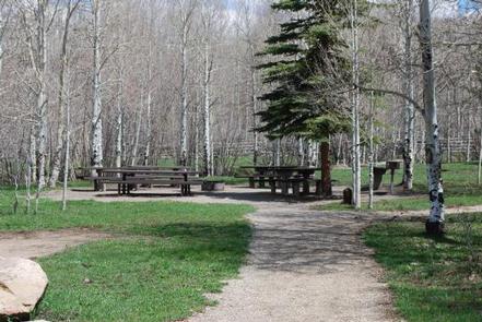
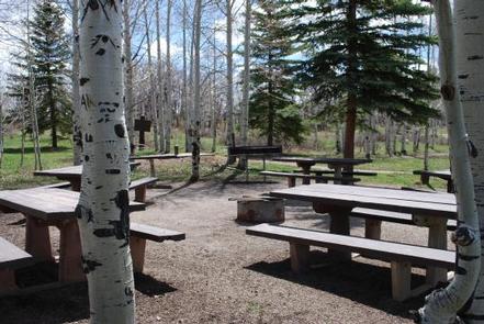
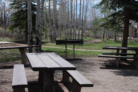
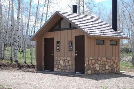
The reservable group site has five double picnic tables, a large group area, a serving table and cooking grills. A vault toilet restroom is located near the group area.

The 12 first-come, first-serve campsites offer one vault toilet and barrier free camping. Parking spaces are small, but can accommodate some RVs.

Horses are not allowed in the campground, but there are corrals with five sites adjacent to the campground on Forest Road 561.

Natural Features

The campground is situated at an elevation of 8,500 feet. Surrounded by whispering aspen and making for a great camping atmosphere, visitors will enjoy the sounds of birds and the occasional horse neighing in the corrals across the road.

Nearby Attractions

Visit the Jackson Gulch Reservoir, just six miles south of the campground for a relaxing day of fishing or hike one of the many trails nearby the campground. Visit the historic town of Mancos and learn about the Ancestral Puebloans who inhabited this area from approximately AD 1 to AD 1300.

Reservation

More from CampingHiking.net:

Miller River Group Camp, Washington Campground Images, Info & Reservations

Listen Directions From I-5 north, take exit 194 to Highway 2. Continue for about 48 miles, then turn south at the Money Creek Campground sign. Continue about 3 miles to the campground. Phone 360-804-1103 Activities BIKING, CAMPING, FISHING, HIKING, WILDLIFE VIEWING Keywords MILR,MT. BAKER-SNOQU NF – FS Related Link(s) Rec

COLORADO CAMPGROUND, Colorado Campground Images, Info & Reservations

Listen Directions From the I-25 and Highway 24 intersection in Colorado Springs, travel west on Highway 24 for about 18 miles to the intersection with Highway 67 in Woodland Park. Turn right (north) on Highway 67 and drive about 6.7 miles to Colorado Campground. The campground is on the right

BIG CREEK LAKES CAMPGROUND, Colorado Campground Images, Info & Reservations

Listen Directions From Walden, follow Route 125 north for 9 miles into Cowdrey. Turn left (west) onto CR 6W and travel 18 miles to Pearl. Turn onto Forest Road 600 and drive for 6 miles, following signs to campground. Phone 970-723-2700 Activities BOATING, CAMPING, FISHING, HIKING, WILDLIFE VIEWING Keywords BIGL,MEDICINE

ROMBO, Montana Campground Images, Info & Reservations

Listen Directions From Darby, Montana drive south on Highway 93 to Forest Road 473. Turn right toward Painted Rocks State Park. Continue approximately 18 miles to the campground, which is on the right. Phone 406-821-3269 Activities BIKING, BOATING, HISTORIC & CULTURAL SITE, CAMPING, FISHING, HIKING, WATER SPORTS, WILDLIFE VIEWING Keywords

NORTH WALDO, Oregon Campground Images, Info & Reservations

Listen Directions From Oakridge, follow Hwy 58 east for 25 miles to the Waldo Lake Road (FS Road 5897). Follow Waldo Lake Road for 11 miles to FS Road 5898. Follow FS Road 5898 to FS Road 5895. Continue on FS Road 5895 to North Waldo Campground. Phone 801-226-3564 Activities

HORNET LOOKOUT, Montana Campground Images, Info & Reservations

Listen Directions From Columbia Falls, take Nucleus Avenue north through Columbia Falls and turn east on Railroad Street. At the stop sign, the road becomes the North Fork Road. Continue on North Fork Road for about 45 miles and over the railroad overpass. Turn left (west) on Whale Creek Road