TRAP CREEK CAMPGROUND, ID Campground Reservation, Info, Images, Map, Directions

TRAP CREEK CAMPGROUND, Idaho Campground Images, Info & Reservations

Listen

Directions

From Stanley, Idaho, take State Highway 21 west 12 miles. Take Forest Road 540 to Trap Creek Campground, located adjacent to State Highway 21.

Phone

928-537-8888

Activities

BIKING, CAMPING, FISHING, HIKING, WILDLIFE VIEWING

Keywords

TRAP,SAWTOOTH NF – FS

Related Link(s)

Rec Area Info & Images

Idaho State Tourism

Forest Service Concessionaire

Idaho State Road Conditions

Overview

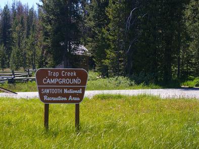
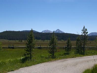
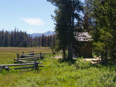
Trap Creek Campground is located in a beautiful valley at the foot of the Sawtooth Mountain Range in central Idaho.

Recreation

Trap Creek is situated in the Sawtooth National Recreation Area. A myriad of excellent hiking and biking opportunities are available, with an estimated 750 miles of trails crisscrossing the valley and surrounding mountains, including the Idaho Centennial Trail, which passes through the site.

Expansive and scenic Elk Meadow is near the campground, providing a great location for bird and wildlife watching.
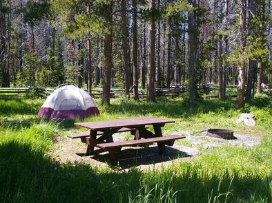
Facilities

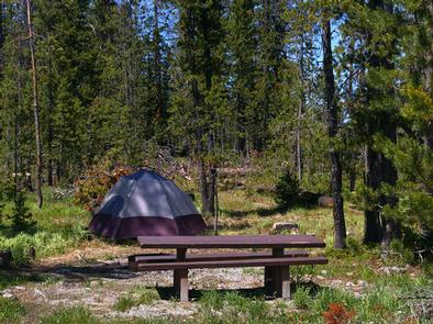
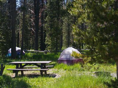
This small campground offers one group site that consists of three smaller sites. If the group site is not reserved, the individual sites are available on a first-come, first-served basis.

Vault toilets are provided. The road to the site and the parking spur within are paved.

Natural Features

Summer wildflowers are plentiful and a mixed stand of pines provides partial shade. Trap Creek flows nearby. The campground sits at an elevation of 6,670 feet, and temperatures are cool, with an average summer high of 78 degrees and a low of 40 degrees.

Nearby Attractions

Numerous sparkling lakes and streams, including the Salmon River, dot the area, making for great rainbow and native Westslope cutthroat trout fishing. Stanley and Redfish Lakes are nearby, offering great boating, water skiing, canoeing, kayaking and fishing.

Popular area events include an Arts and Crafts Fair in July, and Wagon Days, Salmon Festival, Quilt Fair and Fireman’s Ball in September.

Reservation

More from CampingHiking.net:

ELK CREEK CAMPGROUND, Colorado Campground Images, Info & Reservations

Listen Directions Elk Creek is located off of US Hwy 50 between Gunnison and Montrose, along Blue Mesa reservoir. Phone 970-641-2337 Activities BIKING, BOATING, CAMPING, INTERPRETIVE PROGRAMS, FISHING, HIKING, HUNTING, VISITOR CENTER, WATER SPORTS, WILDLIFE VIEWING, DAY USE AREA, SWIMMING SITE Keywords ELKC,CURECANTI NATIONAL RECREATION,ELK CREEK CURECANTI NRA,CURECANTI Related Link(s)

BOULDER OAKS EQST, California Campground Images, Info & Reservations

Listen Directions Boulder Oaks is located 55 miles east of San Diego, California. Take I-8 to the Buckman Springs Road exit. Continue east on Old Highway 80 for 2 miles to the campground entrance. Campground is located on the right hand side of the road when heading east. Phone 619-445-6235

DAWSON CABIN, Colorado Campground Images, Info & Reservations

Listen Directions From Buena Vista, Colorado, go about 15 miles north on Highway 24 towards Leadville. Turn left on County Road 390 at Clear Creek Reservoir. Go about 6 miles west on County Road 390, then turn right (north) onto the cabin driveway. The cabin is about 100 yards from

LODGEPOLE (Taylor River), Colorado Campground Images, Info & Reservations

Listen Directions From Gunnison, Colo., travel north on Highway 135 for 10 miles to Almont. Turn right (northeast) onto Taylor Canyon Road and proceed 12 miles to the campground entrance, which is on the right. Phone 970-642-0566 Activities BIKING, BOATING, CAMPING, FISHING, HIKING, HORSEBACK RIDING Keywords LODG,LODGEPOLE Gunnison Grand Mesa,GUNNISON,GM,UNCOMP

ALLEN SPRINGS CAMPGROUND, Oregon Campground Images, Info & Reservations

Listen Directions From Sisters OR: Travel 9.6 miles northwest on Highway 20, then 11.1 miles north on Forest Road 14. Phone 541-323-1746 Activities CAMPING Keywords Related Link(s) Rec Area Info & Images Oregon State Tourism Oregon State Road Conditions Overview Like the other campgrounds on the Metolius, Allen Springs is

MEADOWS CABIN, Wyoming Campground Images, Info & Reservations

Listen Directions From Afton, WY, take Highway 89 north approximately 31 miles to Alpine, WY. At Alpine, turn right (south) onto Greys River Road (Forest Road 10138) and drive about 26 miles to Box Y Guest Lodge turnoff. Turn right (west), cross the Greys River Bridge, and then travel 1/4