PINEY BAY, AR Campground Reservation, Info, Images, Map, Directions

PINEY BAY, Arkansas Campground Images, Info & Reservations

Listen

Directions

From London, Arkansas, take US-64 west for 3 miles to State Route 359 north. Continue for 3.5 miles and follow signs into the campground.

Phone

479-885-3029

Activities

BOATING, CAMPING, FISHING, DAY USE AREA, SWIMMING SITE

Keywords

PINB,DARDANELLE LAKE-ARK. RIV.NAV.,DARDANELLE LAKE

Related Link(s)

Rec Area Info & Images

Arkansas State Tourism

Arkansas State Road Conditions

Overview

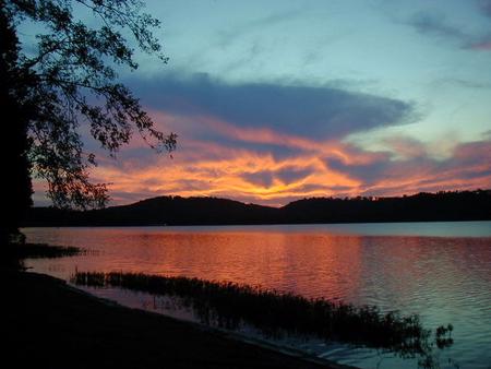
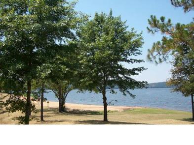
Piney Bay Campground sits along Dardanelle Lake in western Arkansas. Campers come here to get a break from the city and take advantage of the ample swimming, boating and fishing opportunities.

Recreation

Picnicking, boating and fishing are favorite pastimes. The lake is brimming with white bass, largemouth bass, bream, crappie and large catfish.

Facilities

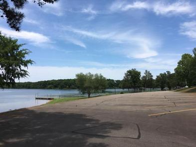
Piney Bay offers 68 reservable campsites, all equipped with electric hookups, along with a large group picnic shelter and over 20 walk-in campsites. Campers enjoy hot showers, two boat ramps, a playground and a swim beach.

Natural Features

Situated between the Ozark and Ouachita National Forests, Dardanelle Lake creates an excellent setting for nature lovers. The lake stems from the Arkansas River and spans 40,000 acres. Wooded area and hills surround the lake.

The region is a favorite destination for bald eagles in wintertime.

Nearby Attractions

Bona Dea Trails and Sanctuary, with nearly 86 acres of wetlands and low woods, provide an ideal habitat for native wildlife. Visitors can explore the area on the six-mile trail system.

Reservation

More from CampingHiking.net:

AUNTS CREEK, Missouri Campground Images, Info & Reservations

Listen Directions From Branson, Missouri, take Highway 13 south for about 4 miles. Turn west onto Highway 00 and continue for nearly 3 miles to the campground. Phone 417-739-2792 Activities BIKING, BOATING, CAMPING, FISHING, HIKING, PICNICKING, WATER SPORTS, WILDLIFE VIEWING, DAY USE AREA, SWIMMING SITE, PHOTOGRAPHY, SWIMMING, RANGER STATION, WATER

SAN AUGUSTINE, Texas Campground Images, Info & Reservations

Listen Directions From Pineland, TX, take FM 83 west 6 miles, then south on FM 1751 for 4 miles to the park entrance. Phone 409-384-5716 Activities BOATING, CAMPING, FISHING, HUNTING, SWIMMING SITE Keywords SATX,SAM RAYBURN RESERVOIR,SAM RAYBURN LAKE,SAN AUGUSTINE PARK,SAM RAYBURN RESERVOIR Related Link(s) Rec Area Info & Images Texas

DAVIDOF LAKE CABIN, Alaska Campground Images, Info & Reservations

Listen Directions Accessible early June through October. Located 40 air miles southeast of Sitka, east of Whale Bay, within South Baranof Wilderness Area. Access is by float plane only, and takes 35 minutes from Sitka. For geographic features surrounding cabin, refer to USGS topographic map Port Alexander C-3. Phone 907-747-6671

LODGEPOLE CAMPGROUND (WA), Washington Campground Images, Info & Reservations

Listen Directions From Yakima, take Highway 12 west to the junction with Highway 410. Travel 39 miles on Highway 410 to the campground entrance. Phone 541-338-7869 Activities CAMPING, FISHING, HIKING, SWIMMING SITE Keywords LDPL,OKANOGAN – WENATCHEE NF -FS,LODGEPOLE,LODGEPOLE CAMPGROUND Related Link(s) Rec Area Info & Images Washington State Tourism Forest

LAUREL BRANCH, Kentucky Campground Images, Info & Reservations

Listen Directions From Louisville, KY: Begin at ramp onto I-64 West toward New Albany/St. Louis, traveling 22.3 miles. Take the IN-135, Exit Number 105, toward Palmyra/Corydon, onto IN-135 South toward Corydon, traveling 16.7 miles. Continue on Bypass Road KY-79 for 2.1 miles. Turn right onto KY-79, traveling 10.1 miles. Continue