Black Canyon of the Gunnison NP South Rim Campground, CO Campground Reservation, Info, Images, Map, Directions

Black Canyon of the Gunnison NP South Rim Campground, Colorado Campground Images, Info & Reservations

Directions

The park is located approximately 250 miles SW of Denver. South Rim: 15 miles east of Montrose, via U.S. Hwy 50 and CO Hwy 347.

Phone

970-249-1914 EXT 425

Activities

CAMPING, INTERPRETIVE PROGRAMS, FISHING, HIKING, PICNICKING, VISITOR CENTER, WILDLIFE VIEWING, WILDERNESS, DAY USE AREA, PHOTOGRAPHY, STAR GAZING, BIRDING, CROSS COUNTRY SKIING, EVENING PROGRAMS, GUIDED INTERPRETIVE WALKS, SCENIC DRIVE, BACKPACKING, AMPHITHEATER

Keywords

SRCG,Black Canyon National Park,Gunnison National Park,Gunnison Nation Forest,Black Canyon,Black Canyon of Gunnison,Black Canyon

Related Link(s)

Rec Area Info & Images

Colorado State Tourism

Colorado State Road Conditions

Overview

A camping trip to the Black Canyon of Gunnison National Park makes for a beautiful getaway for sightseeing, stargazing, and hiking. The park protects the most dramatic section of the Gunnison River Canyon; no other canyon in North America combines the narrow opening, sheer walls, and startling depths of Black Canyon.

Recreation

Take one of many spectacular hikes such as the Oak Flat Loop Trail, and watch for the black-billed magpie. In summer, catch an evening educational program in the campground amphitheater. In winter, try snowshoeing on Rim Rock Trail or go cross country skiing on South Rim Drive.

Facilities

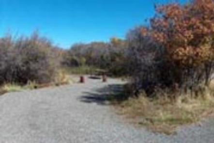
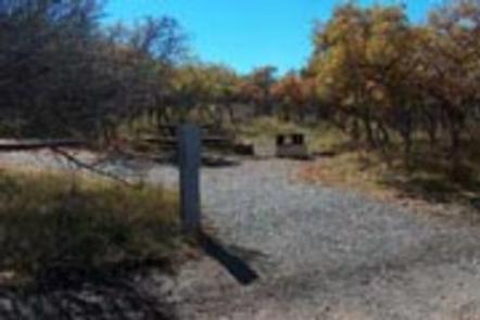
Campsites are open year round, but drinking water is only available mid-May through mid-October. Electric hookups are in Loop B and available in the summer only.

Natural Features

Perched on the South Rim of the Black Canyon, this campground is surrounded by scrub oak forests and sits atop ancient hard rocks. Deer, grouse, bears, and bobcats are known to frequent the area.

Nearby Attractions

Visit the Cimarron Rail Exhibit to see railcars and the last remaining railroad trestle on the Black Canyon of the Gunnison route. Head upstream to Curecanti National Recreation Area to enjoy water recreation on Colorado’s largest reservoir.

Reservation

More from CampingHiking.net:

FIELD TRACT CAMPGROUND, New Mexico Campground Images, Info & Reservations

Directions Field Tract Campground is located 10 miles north of Pecos on the right-hand side. Phone (505) 757-6121 Activities CLIMBING, CAMPING, FISHING, HIKING Keywords Related Link(s) Rec Area Info & Images New Mexico State Tourism New Mexico State Road Conditions Overview Field Tract Campground is located on the banks of

MONO CREEK, California Campground Images, Info & Reservations

Directions From Clovis, California, take Highway 168 north 70 miles to Huntington Lake Campground office at Eastwood. Take Kaiser Pass Road to Mono Creek Campground. Phone 559-893-2111 Activities BOATING, CAMPING, INTERPRETIVE PROGRAMS, FISHING, HIKING, HORSEBACK RIDING Keywords MONO,SIERRA NF – FS Related Link(s) Rec Area Info & Images California State

MINERS GULCH, Utah Campground Images, Info & Reservations

Directions From Duchesne, Utah: Take Highway 87 north for 15 miles to the Mountain Home turnoff. Turn left and continue 2.5 miles north to the Rock Creek Store. Turn left toward Rock Creek Canyon and proceed approximately 15 miles to the campground. You’ll see a sign for Miners Gulch and

BALD MOUNTAIN CAMPGROUND, Wyoming Campground Images, Info & Reservations

Directions From Lovell, Wyoming, take U.S. Highway 14A (not U.S. Highway 14) 33 miles east. The highway has a 10% grade; not recomended for RVs and motorhomes. From Dayton, Wyoming, take U.S. Highway 14/14A west 73 miles via Burgess Junction. This is the recommended route for RVs and motorhomes. Phone

MODOC, South Carolina Campground Images, Info & Reservations

Directions From I-20, take Exit 200 (River Watch Parkway). Turn right, drive 2 miles to Furys Ferry Road (HWY 28 West). Turn right, drive 13 miles to Clarks Hill, SC. Continue northwest on HWY 221 for approximately 4 miles to campground entrance. Phone 864-333-2272 Activities BOATING, CAMPING, FISHING, SWIMMING, KAYAKING

MOUNT PRINCETON, Colorado Campground Images, Info & Reservations

Directions From Buena Vista, Colorado, take Highway 285 south to Nathrop. Turn west on County Road 162 and travel 7 miles to the campground. Phone CAMPGROUNDS DO NOT HAVE PHONE SERVICE, CALLING TO CHECK AVAILABILITY PRIOR TO ARRIVAL IS NOT POSSIBLE. FOR RESERVATIONS CALL: 1-877-444-6777 Activities HISTORIC & CULTURAL SITE,