LOWER PENSTEMON, ID Campground Reservation, Info, Images, Map, Directions

LOWER PENSTEMON, Idaho Campground Images, Info & Reservations

Directions

Travel south on Twin Falls County Road G3 which becomes Forest Road 515, commonly known as Rock Creek Road, for approximately 27 miles from Hansen.

Phone

208-678-0430

Activities

BIKING, CAMPING, HIKING, HORSEBACK RIDING, HUNTING, WILDLIFE VIEWING

Keywords

LOWP,SAWTOOTH NF – FS

Related Link(s)

Rec Area Info & Images

Idaho State Tourism

Idaho State Road Conditions

Overview

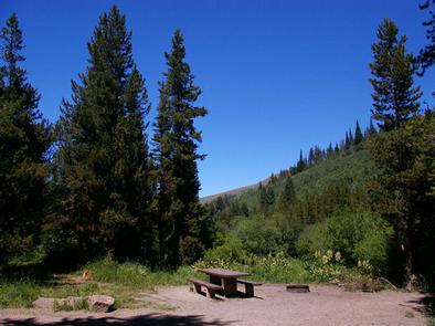
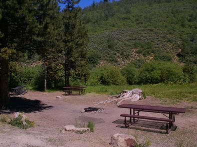
Lower Penstemon Campground is located along the scenic Rock Creek Road, in southern Idaho, at an elevation of 6,600 feet. Visitors come to the area to enjoy its abundant trails and natural beauty.

Recreation

Hiking, mountain biking, horseback riding and off-road vehicle trails crisscross the surrounding area. Third Fork, Pike Mountain, Rim View and Porcupine Spring trails all begin nearby. Rock Creek runs along the campground, offering good trout fishing.

Facilities

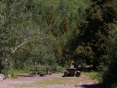
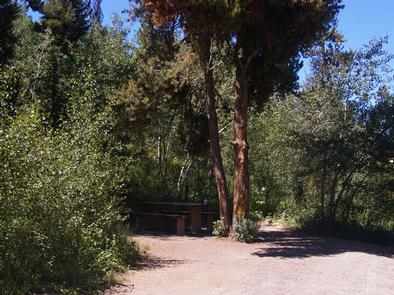
The campground contains single-family campsites with picnic tables and campfire rings. Vault toilets and drinking water are provided. Roads and parking spurs within the campground are gravel. Because the campground is situated along the main road, some noise from passing cars is to be expected.

Natural Features

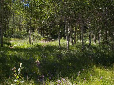
The campground is situated in a mixed conifer and aspen forest, just off Rock Creek Road. Most sites have partial shade. Summer wildflowers dot the landscape and wildlife can be seen frequently in the surrounding area.

Reservation

More from CampingHiking.net:

Big Meadow Campground, California Campground Images, Info & Reservations

Directions Take Highway 180 east to the Kings Canyon National Park entrance, where you will be required to purchase a forest/park permit. After entering the park, continue 2 miles where you will stay to the right as though you were going to Sequoia National Park. Continue on the General’s Highway

LAKE THREE, Wisconsin Campground Images, Info & Reservations

Directions 34412 Mineral Lake Rd. (FR 198) From Mellen, Wisconsin; Take County Highway GG west for about 8 miles. Turn right onto Forest Service Road 187/Mineral Lake Road and continue for 3 miles to the intersection with Forest Service Road 198/Pine Stump Corner. Turn right and continue less than a

TWO LAKES, Wisconsin Campground Images, Info & Reservations

Directions From Drummond follow Forest Road 213 southeast to the intersection of Forest Road 213 and 216. Veer left (east) and continue on Forest Road 213 for 2 miles. Veer right (south) onto Forest Road 214 and travel 0.5 mile to the campground. Phone 715-739-6334 Activities BIKING, BOATING, CAMPING, FISHING,

HORSE HEAVEN GROUP, California Campground Images, Info & Reservations

Directions The campground is located 50 miles east of San Diego, California. Take I-8 to Sunrise Highway exit. Go approximately 14 miles until you see the Horse Heaven Group Campground sign and turn down the campground entrance road. Phone 619-445-6235 Activities BIKING, CAMPING, HIKING, HORSEBACK RIDING, WILDLIFE VIEWING, MOUNTAIN BIKING,

WELDON ISLAND, Georgia Campground Images, Info & Reservations

Directions From Interstate 85, take Exit 4 and turn East onto Old Dobbins Bridge Road.Turn right on Andersonville Road and follow the brown directional signs. Hattons Ford ramp is located at the end of Andersonville Road. Townville, SC, 29689 Phone 888-893-0678 HARTWELL PROJECT OFFICE Activities BOATING, FISHING, PICNICKING, SWIMMING, WATER

Twelvemile Beach Campground, Michigan Campground Images, Info & Reservations

Directions Phone 906-387-3700 Activities CAMPING, HIKING, BEACHCOMBING, BACKPACKING, ACCESSIBLE SWIMMING Keywords Related Link(s) Rec Area Info & Images Overview Twelvemile Beach Campground is a beautiful campground along Lake Superior located within the Pictured Rocks National Lakeshore, just 15 miles west of Grand Marais. There are 36 sites total, including 2