
Directions
There are two trails used to reach the cabin; the Black Mountain Ski Trail and East Pasture Loop XC Ski Trail:
Recommended: Black Mountain Ski Trail is located off Carter Notch Road in Jackson: From Route 16, turn into Jackson Village. Follow the loop through town until you reach 16B/Carter Notch Road. Follow Carter Notch Road for 3.9 miles until you reach Melloon Rd. Turn right onto Melloon Road and follow for about 1/3 mile. Parking is available for 4 – 6 vehicles. You will see the trail sign at the beginning of a private drive; the trailhead is on your right about 100 feet up the drive. Please stay on the trail and respect private landowners’ rights. This trail reaches Black Mountain Cabin in 1.4 miles via a moderate grade.
East Pasture Loop XC Trail is maintained as a groomed XC ski trail in the winter by Jackson Ski Touring Foundation (pass required) accessed at the top of Black Mountain Road in Jackson. From Route 16, turn into Jackson Village (Route 16A). Follow the loop through town until you reach Route 16B/Black Mountain Road. Turn onto Black Mountain Road and follow for about 2 miles. Just past Black Mountain Ski Area, Black Mountain Road veers to the left and Dundee Road continues straight ahead. Veer left on Black Mountain Road for another 0.5 miles to the East Pasture Trailhead. Parking is available for about 10 vehicles. The trail begins on private land so please be respectful.
Phone
603-447-5448
Activities
CAMPING, HIKING, HUNTING, WINTER SPORTS, WILDLIFE VIEWING
Keywords
BMCA,WHITE MOUNTAIN NF -FS
Related Link(s)
New Hampshire State Road Conditions
Overview
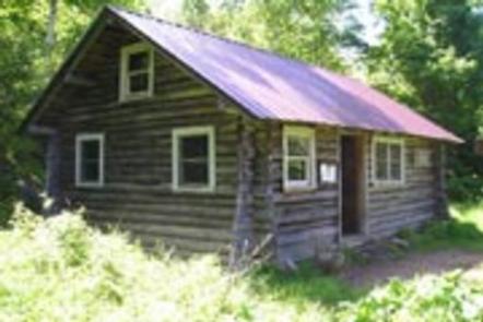
Black Mountain Backcountry Cabin was built in the 1930s by the Civilian Conservation Corps and sits on what was once pasture land. The cabin was renovated in 1992, though its original character was maintained. The surrounding pasture was cleared as well to provide the scenic views that guests enjoy today. The Black Mountain Ski Trail is used to hike or ski to the cabin, depending on the season. The 1.4-mile trail starts at an elevation of 1,250 feet, and the cabin sits at an elevation of 2,450 feet. Guests should be prepared to transport all their gear and supplies on foot.
Recreation
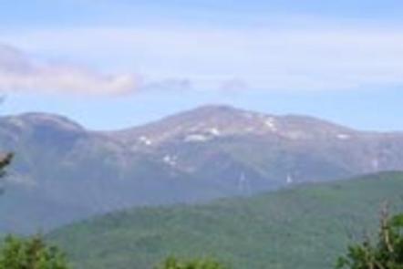
The Black Mountain Ski Trail used to access the cabin is a popular backcountry ski trail. It continues 0.4 miles beyond the cabin to the summit of Black Mountain, which offers views of Carter Dome, Carter Notch and Wildcat Ridge.
A groomed trail system operated by Jackson Ski Touring Foundation is within a mile of the cabin. A trail pass is required.
Facilities
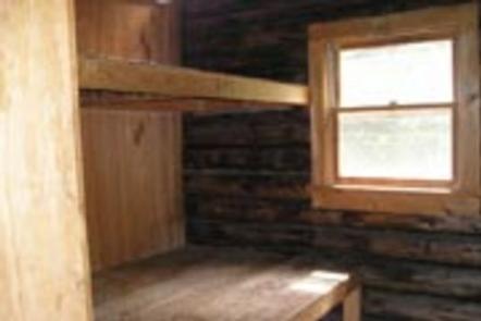
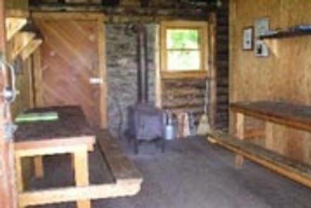
Black Mountain Cabin is very rustic with minimal amenities. There are 8 wooden bunks, 2 small tables, benches and a wood stove. An outhouse with a vault toilet is located a short distance away. There is a broom provided as guests are requested to tidy up the cabin before leaving.
Water and electricity are not available. Any water taken from the natural sources should be treated or boiled, but it is recommended that guests bring their own water. Bedding and sleeping pads are not provided. Recommended items include matches, food, cooking utensils, trash bags, toilet paper, a camp stove, first aid kit, flashlight or lantern, extra batteries, firewood and/or a cutting tool for dead and down wood.
The amount of available firewood in the area cannot be guaranteed. The cabin is not insulated, so winter guests should be prepared for temperatures inside to be almost the same as the outside, even when the wood stove is in use (more details on the cabin).
Natural Features
This cabin is located on the west side of Black Mountain and offers views of the 4,400-foot Wildcat Ridge and 6,288-foot Mount Washington – the tallest peak in the northeastern United States. The cabin is surrounded by maple and spruce trees.
There are 237 species of birds living in White Mountain National Forest. Other inhabitants of the forest include moose and black bears (bear safety information).