

Directions
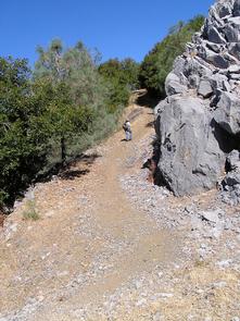
From Redding, California, take Interstate 5 north approximately 20 miles to Gilman Road, exit 698. Turn right and follow Gilman Road approximately 5 miles to road 35N04. Turn left on the road 35N04. This steep, rocky, dirt road is not recommended for low clearance passenger vehicles. Travel approximately 5 miles to the locked gate. Due to rocky, slippery, steep terrain, the last quarter-mile section of road access to the lookout is for foot traffic only.
Phone
530-275-8113
Activities
BIKING, HISTORIC & CULTURAL SITE, CAMPING, HIKING, HUNTING, WILDLIFE VIEWING
Keywords
HIRZ,SHASTA-TRINITY -FS
Related Link(s)
California State Road Conditions
Overview
The McCloud River Wintu tribe held Hirz Mountain in reverence and had a name for it in their own language. But it was a white miner, Henry Hirz, who gave the mountain its modern name. Hirz was a gold miner who lived on Hirz Creek in the 1860s and was one of the earliest white men in the McCloud River country.
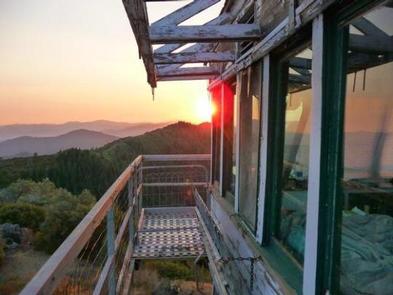
When the lookout was built, it was originally a structure that sat on the ground. The mountain was a strategic location for detecting fires because it had a direct view into the headwaters of the McCloud River and most of its tributaries. In 1937, the Forest Service and the Civilian Conservation Corps (CCC) rebuilt the Hirz Mountain Lookout cabin and included a garage and outhouse. It was one of the last CCC-era lookouts to be built. In 1949, a steel tower was added, constructed of a steel K-brace tower that stands 20 feet above ground level.
Coming here is not for the faint of heart. The access road is rocky and steep with limited visibility – high clearance vehicles are recommended – and the last quarter-mile must be traversed on foot. Those who make the journey are rewarded with unforgettable views of the landscape by day and the stars at night.
Recreation
The main recreational activities at Hirz Mountain Lookout are sightseeing and stargazing, and this is an ideal setting for those with a passion for photography. Visitors may want to bring binoculars to go birding and wildlife watching.
There are also opportunities to hike, mountain bike and hunt in the area.
Facilities
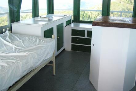
There are two twin beds and two additional mattresses in the lookout cabin, offering sleeping space for four people. There is a picnic table below the lookout and a vault toilet in a separate building. Cabinets and dressers are available for storage. Visitors will find cleaning supplies for tidying up the cabin when they leave.
The lookout has no cooking facilities, linens, bedding, water or electricity. Visitors must bring enough water for the length of their stay, as well as garbage bags to pack out their trash. Appropriate footwear is recommended for the hike up to the lookout. Other items to consider include food, a cell phone, cook stove, matches, a cooler with ice, personal items, first aid kit, flashlights or lanterns and extra batteries. A California campfire permit is required for the use of a portable gas stove, jellied petroleum or pressurized liquid fuel for cooking (click here for more information about Hirz Mountain Lookout).
Natural Features
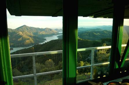
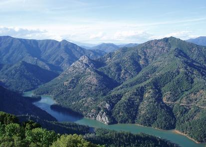
This lookout tower sits atop Hirz Mountain at an elevation of 3,540 feet, offering 360-degree views of Mt. Shasta’s snow-laced peak to the north, Mt. Lassen to the southeast and the gray limestone exposures of Hirz Mountain itself. The narrow blue-green ribbon of the McCloud River Arm winds past the east side of Hirz Mountain, extending north and south as far as the eye can see. Visitors to Hirz Mountain Lookout are advised to use caution, as rattlesnakes and bears frequent the area (click here for information on bear safety).