

Directions
From Missoula, Montana, drive to Greer, Idaho. Follow State Highway 11 to Weippe. Continue on toward Pierce. Turn right onto French Mountain Road 250. Follow Road 250 (paved for 17 miles, gravel thereafter) to the Bungalow Bridge, which spans the North Fork Clearwater River. Turn right and remain on Road 250. Continue to the junction with Mush Saddle Road 711, about 16 miles; turn left onto Road 711.
ORV riders can drive further on 2 miles to the junction with Cool Creek Road 5295 and turn right. This is a single-lane, dirt-surface road rarely graded or cleared and is slippery when wet. Watch for falling rocks. Climb steeply to the junction with Road 5295A. Make a sharp turn right. Two miles later, park and follow Flat Mountain Trail 176 for 2 miles to the cabin. About 1 mile in, Elizabeth Mountain
Trail 445 forks to the right. Stay left. About one-quarter mile before you get to the cabin, Pot Mountain Trail 169 forks left. Stay right and travel to the cabin.
From Lewiston, Idaho, follow U.S. Highway 12 east to Greer, Idaho. Turn left onto Highway 11 and proceed as described above.
Phone
208-476-4541
Activities
BIKING, HISTORIC & CULTURAL SITE, CAMPING, FISHING, HIKING, HORSEBACK RIDING, HUNTING, WILDLIFE VIEWING, FIRE LOOKOUTS/CABINS OVERNIGHT, ORGANIZATION SITE FS OWNED, MOUNTAIN BIKING, BERRY PICKING, STAR GAZING, BIRDING, SCENIC DRIVE, BACKPACKING, MUSHROOM PICKING
Keywords
COCB,CLEARWATER NF -FS
Related Link(s)
Overview
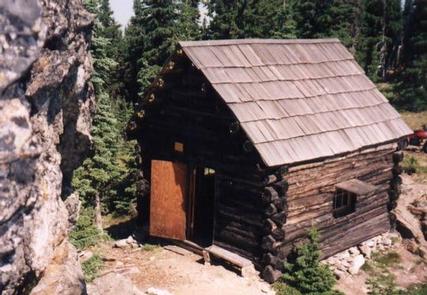
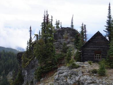
As a qualifying inclusion to the National Register of Historic Places, the primitive 12×14 log cabin was originally constructed to shelter firefighters and other work crews in 1931. Although Forest Service personnel and volunteers shored up the cabins foundation, re-shingled the roof and installed a wood heating stove, guests must bring their own supplies and gear for a comfortable stay as there are no linens or toiletries provided. The popular cabin is perched on a ridge line just off Pot Mountain trail #169 overlooking the Elizabeth Creek drainage and Ice Lake. The trailhead to the cabin is not assessable with low clearance vehicles, and the 2+ miles of trail from the trailhead to the cabin is a moderately difficult, multi-use trail with several steep grades. Although assessable by ATVs/UTVs the roads and trails leading to the cabin can be partially or fully blocked by debris or snow pack in the early season, and off trail/road motorized travel is prohibited. Visitors are strongly advised to consult the forest website, as well as a map prior to reserving or traveling to the cabin and to call the district information desk with any questions.
Recreation
Due to the unique location, the cabin is an ideal base camp for those looking to reconnect with nature, or as a stopover for a variety of outdoor enthusiasts as they explore the district. Multiple mountain lakes in the vicinity provides a welcome challenge for the avid adventurer looking to find the many secluded fishing holes. There are also several other trails in the vicinity that offer connection to a host of recreation opportunities including; berry picking, hiking, biking, sightseeing, and birding being the most popular. Recreate responsibly, be sure to check the regulations and rules to educate yourself before you recreate by visiting https://idfg.idaho.gov/ and https://www.fs.usda.gov/news/nezperceclearwater/news-events for up to date information.
Facilities
The cabin is a 1930s primitive structure, only providing a shelter from the elements. Two spring beds, a small table with a couple chairs, a modern wood stove, and a pit toilet outhouse are the only amenities provided. There is only one stream as a reasonable water source approximately 1 mile from the cabin on trail #169 that requires treatment before consumption. Guests are required to pick up after their pets/stock, take their trash, and clean the cabin before they check-out with the provided cleaning supplies under the Leave it Cleaner than when you arrived and the Pack it in Pack it out policies so everyone may enjoy their stay.
Natural Features
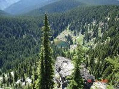
The cabin is tucked into a narrow and rocky saddle atop steep, nearly vertical cliffs directly adjacent to Cold Springs Peak. At 6,731 feet, guests enjoy open views of the Bitterroot Mountains to the east as well as a birds eye view of the Elizabeth Creek valley, Ice Lake, and a small meadow directly below the cabin. The area boasts a wide diversity of wildlife and birds so visitors never know what to expect while enjoying the scenery, but mule deer, mountain lion, black bear, elk, Mountain Bluebird, Mountain Jay, Raven, and Tanager are the most common. Seasonal changes can be particularly enjoyable as the storms blow through the saddle, or the extraordinary fall colors back dropped with mountains capped by advancing snow late in the season.
Nearby Attractions
The North Fork ranger district prides itself on the diversity of world class recreational opportunities ranging from bird/wildlife watching, big game hunting, whitewater rafting, leisurely floats, secluded backpacking/equestrian trails into the high mountain backcountry, to motorized ATV/OHV trail systems providing unique experiences that draws visitors from around the world and of all walks of life.