

Directions
Caldwell Cabin is located approximately 30 miles southwest of Alpine, Arizona and is accessible via Forest Service roads 26 or 276. From Springerville, take U.S. Highway 180/191 to the town of Alpine. Continue south on Highway 180/191 for about 15 miles, towards Hannagan Meadows. Turn right on Forest Service Road 26, at mile marker 240, and continue approximately 11 miles to the intersection. Turn right onto Forest Service Road 24 and go approximately three miles to the junction of Forest Service roads 25 and 276. Turn left and go just over a mile to Forest Road 25H. Turn left and proceed about one mile. At the sign for Caldwell, turn left. Open the gate with the combination padlock provided. The key for the cabin is inside the padlock. Keep the gate closed and locked at all times. All Forest Service roads are gravel. From Clifton, travel north on U.S. Highway 180/191 for approximately 55 miles. The road is paved and is extremely curvy, gaining 4,500 ft. in elevation; use caution and drive slowly (allow three hours from Clifton to the first turnoff). Vehicles longer than 40 feet are not allowed on the lower portion of 180/191. Turn left on Forest Service Road 26, at mile marker 240 and follow approximately 11 miles to the intersection. Turn right onto Forest Service Road 24 and continue approximately three miles to the junction of Forest Service roads 25 and 276. Turn left and go just over a mile to Forest Road 25H. Turn left and proceed about one mile. At the sign for Caldwell, turn left. Open the gate with the combination provided. The key for cabin is inside the padlock. Keep the gate closed and locked at all times. All Forest Service roads are gravel.
Phone
928-339-5000
Activities
BIKING, CAMPING, FISHING, HIKING, HORSEBACK RIDING, HUNTING, PICNICKING, WILDLIFE VIEWING, WILDERNESS, OTHER RECREATION CONCESSION SITE, PHOTOGRAPHY, MOUNTAIN BIKING, OFF ROAD VEHICLE TRAILS, STAR GAZING, BIRDING, WATER ACCESS, SCENIC DRIVE, WILD HORSE VIEWING
Keywords
CALD,APACHE-SITGREAVES NF-FS
Related Link(s)
Overview
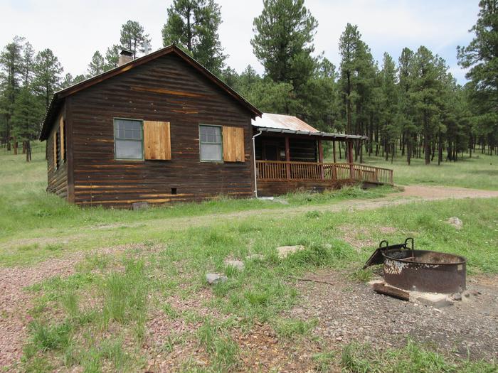
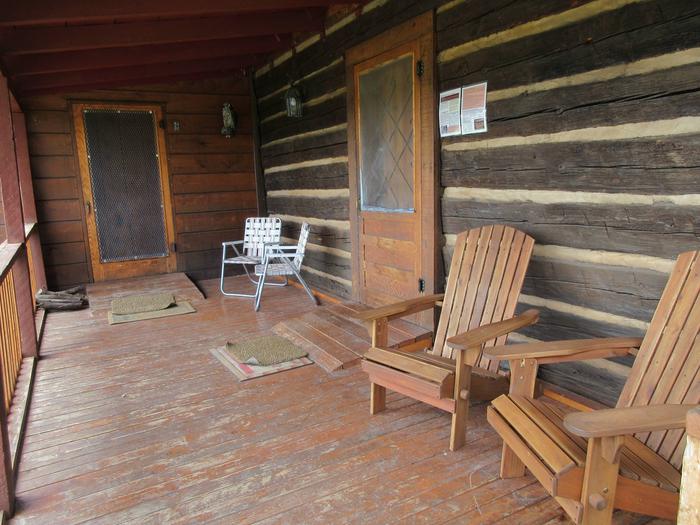
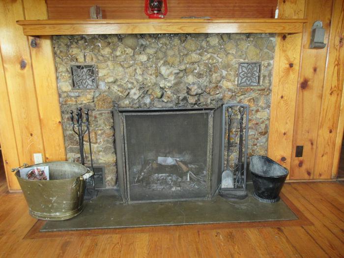
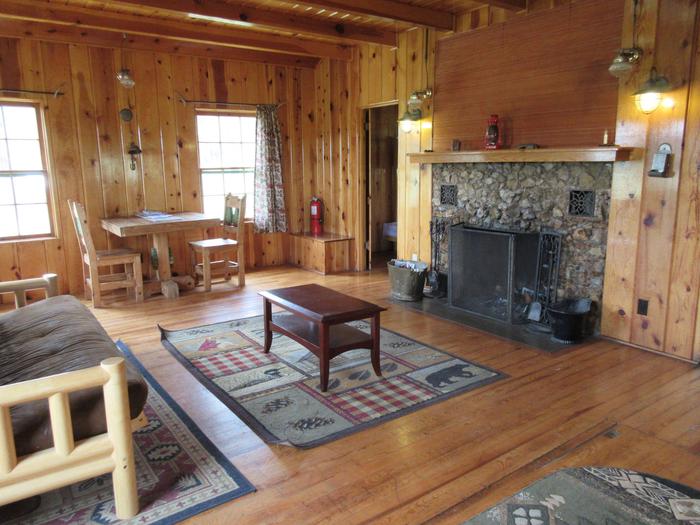
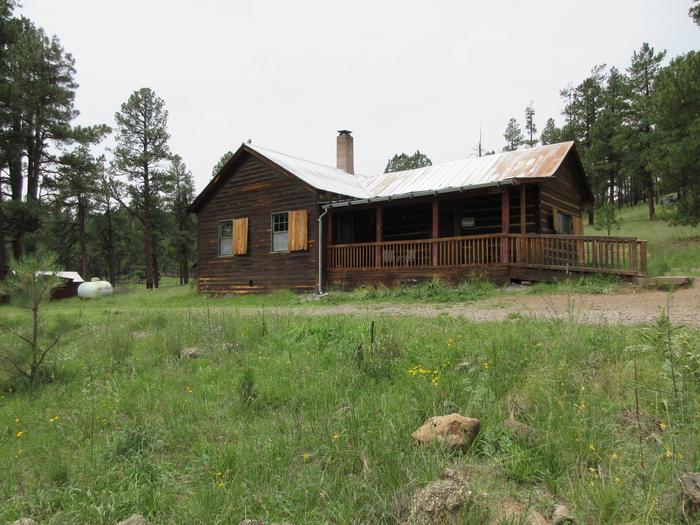
Caldwell Cabin allows up to six visitors to step back in time to a more rustic and historical era in eastern Arizona. Originally constructed in the 1920s, it was a one-room homestead, but the cabin was expanded around 1940, to include a bathroom, small bedroom and living room with a fireplace. Visitors can relax on the front porch and take in the scenic views, or head out for a day of nearby hiking, mountain biking or fishing.
The cabin can be accessed by driving approximately 30 miles southwest of the town of Alpine. Some of the roads are gravel. Guests are responsible for their own travel arrangements and safety, and must bring several of their own amenities.
Recreation
A short drive takes visitors to the Black River Mainstream Trail, which is great for hiking. The Black River is a popular fishing area for trout anglers. From the cabin, guests can watch the sunset from the front porch, dine by the fireplace or walk across the meadow to an overlook of the river.
Facilities
The cabin has many amenities to help visitors feel at home. The kitchen is equipped with a table and chairs, propane stove, propane refrigerator, solar-powered lights, a sink and fold-down bed from the oiginal homestead. Kitchen supplies include pots, pans, utensils, dishes, a perculating coffee pot and can opener. There are two picnic tables and a campfire ring in front of the cabin and two Adirondack chairs on the porch. Lawn chairs are not provided, but are a nice addition if guests would like to bring their own. Visitors must supply their own bedding (including pillows), towels, flashlight, garbage bags, dish washing supplies, toilet paper, food, axe for splitting firewood, and matches and newspaper for starting a fire in the fireplace. Extra warm clothes and rain clothing are suggested. Users must pack out all food and trash and clean the cabin thoroughly, including dishes, floors and counters, prior to checking out of the cabin. Lights and appliances must also be turned off and the door locked. Visitors can explore endless vistas and take part in many outdoor activities in the surrounding Apache National Forest, which encompasses millions of acres of magnificent mountain country in east-central Arizona. Amentities Within the cabin: beds, broom & dust pan, bunkbeds, campfire ring, cooking pots, cooking utensils, drinking water, fireplace, flush toilet, electricity, mattresses, picnic tables, propane cook stove, propane refrigerator, tables and chairs. Things You’ll Need: food, toilet paper and paper towels, bedding and towels, map and compass, spare clothing (rain clothing suggested), sunscreen, trash bags, sunglasses, dish soap and towels, flashlight.
Natural Features
The cabin sits at an elevation of 8,000 feet, in the White Mountains of Arizona. It is nestled among tall ponderosa pine trees and overlooks a large grassy meadow. Because of the high elevation, summer temperatures are pleasant and cool, providing a nice respite from the heat of lower deserts.
Nearby Attractions
Activities within 10 miles of the cabin: fFishing, hiking, horseback riding, hunting, wildlife viewing, mountain biking, off-road vehicle riding, river access and birding.