SANDPIPER RECREATION AREA, IA Campground Reservation, Info, Images, Map, Directions

SANDPIPER RECREATION AREA, Iowa Campground Images, Info & Reservations

Listen

Directions

Physical Address: 7101 NW Polk City Drive Polk City, IA 50226

From I-35, take Exit 92 and go east on First Street approximately 5 miles to HWY 415. Turn right (north) and travel approximately 3 miles to recreation area on the right.

Phone

515-276-4656

Activities

BIKING, CAMPING, FISHING, HIKING, WILDLIFE VIEWING

Keywords

SANDPIPER RECREATION AREA (IA)

Related Link(s)

Rec Area Info & Images

Iowa State Road Conditions

Iowa State Tourism

Overview

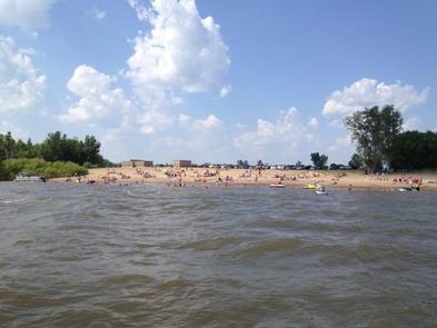
Sandpiper Recreation Area is a day-use facility located on the 26,000-acre Saylorville Lake Project, which stretches over 50 miles up the Des Moines River Valley. The lake provides a wide variety of recreational activities, including boating, swimming, fishing, hiking and hunting.

Recreation

Visitors come to Saylorville Lake for its great boating, sailing, water skiing, windsurfing and swimming opportunities. Anglers fish for walleye, wiper, largemouth bass, catfish, crappie and northern pike.

The paved Neal Smith Trail winds 24 miles from Des Moines to Big Creek State Park and connects the campgrounds on the east side of the lake. It is designated as a National Recreation Trail and is used for biking, hiking, jogging, walking and in-line skating.

Facilities

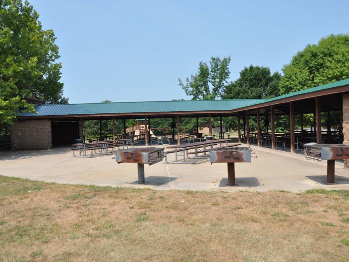
This day-use area contains one large group picnic shelter that can accommodate up to 500 people. Amenities include water and electricity, flush toilets, a playground, large beach, boat ramp and access to hiking and biking trails. A marina is nearby.

Natural Features

Sandpiper is situated in a broad, open area on the northeast side of the lake. Dense timber stands surround the recreation area, but shade is limited within the site.

Wildlife is abundant throughout the project. White-tailed deer, turkeys, pheasants, waterfowl, and other small game animals roam the lands around the lake.

Reservation

More from CampingHiking.net:

HALF MOON LAKE CAMPGROUND, Wyoming Campground Images, Info & Reservations

Listen Directions To reach the campground from Pinedale, drive to the east side of town and turn northeast onto the Fremont Lake road, passing the Pinedale Ranger District Office. Continue straight on the main road for approximately 10 miles to Half Moon Lake Road. Turn right onto road and continue

ACORN CAMPGROUND, California Campground Images, Info & Reservations

Listen Directions From Stockton California, take Highway 26 east for 30 miles. Turn right on Hogan Dam Road and continue for a mile, then follow signs to the campground. Park Headquarters: 2713 Hogan Dam Road Valley Springs, CA 95252 Acorn Campground: 3027 South Petersburg Road Valley Springs, CA 95252 Phone

WILLOW LAKE, Utah Campground Images, Info & Reservations

Listen Directions From Ferron Utah Willow Lake is located approximately 25 miles up Ferron Canyon, on Forest Road 022. From Mayfield Utah Willow Lake is located approximately 27 miles from Mayfield. Head East from up Forest Road 022, turn left on Skyline Drive at 12 Mile Campground then following signage

Indian Creek (WA), Washington Campground Images, Info & Reservations

Listen Directions From Yakima, travel 37 miles west on Highway 12 (White Pass Highway) to the campground entrance, about 16 miles west of the junction of 12 and 410. From Packwood, travel east on Highway 12. The campground is about 20 miles east of White Pass. Phone 541-338-7869 Activities BIKING,

HULL CABIN, Arizona Campground Images, Info & Reservations

Listen Directions The cabin is located approximately 16 miles east of the town of Tusayan, Arizona on a graded gravel road. From Highway 64/180, turn east onto Forest Road 302 just south of the Grand Hotel in Tusayan. Turn left at the junction of Forest Roads 302 and 310. Follow