SPRING MOUNTAINS VISITOR GATEWAY GROUP PICNIC SITES, NV Campground Reservation, Info, Images, Map, Directions

SPRING MOUNTAINS VISITOR GATEWAY GROUP PICNIC SITES, Nevada Campground Images, Info & Reservations

Listen

Directions

From Las Vegas, Nevada, take U.S. Highway 95 north to the junction with State Route 157/Kyle Canyon Rd. Turn left and travel approximately 17 miles to the Spring Mountains Visitor Gateway.

Phone

702-872-5486

Activities

BIKING, CAMPING, HIKING, DAY USE AREA

Keywords

Related Link(s)

Rec Area Info & Images

Nevada State Road Conditions

Nevada State Tourism

Overview

The Spring Mountains Visitor Gateway (SMVG) complex includes a visitor center, an education and research building, two amphitheaters, two picnic sites and over 40 miles of adjoining trails. The complex houses the Silent Heroes of the Cold War National Memorial – the only national monument dedicated to the Cold War era, honoring the thousands of individual who worked covertly for the United States government during the Cold War. SMVG is also home to the Seven Stones Plaza, which celebrates indigenous people – seven Southern Paiute tribes known collectively as Nuwuvi (or "the people") and their longstanding ancestral relationship with their creation place in the Spring Mountains. The SMVG is both a destination and a gateway to provide visitors with everything needed to appreciate and enjoy the Spring Mountains.

Recreation

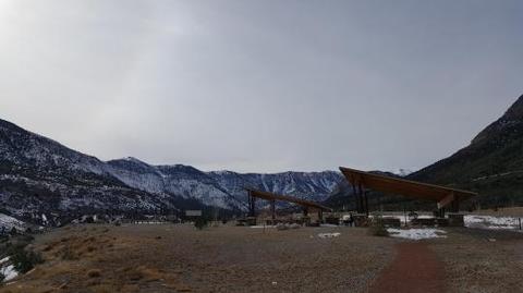
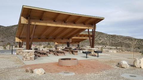
The picnic areas are near a visitor center, two amphitheaters and 40 miles of trails. The Silent Heroes of the Cold War National Memorial is also on the same property. The picnic areas are a short drive from camping areas and scenic outlooks.

Facilities

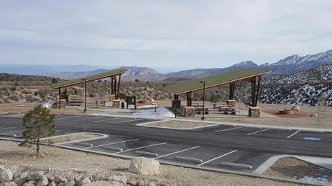
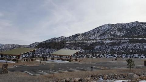
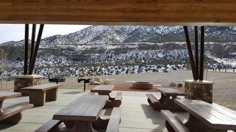
This year-round picnic area contains two group picnic campsites, which meet accessibility standards. Sites are equipped with picnic tables, campfire ring and grills. Flush toilets and drinking water are provided. Roads and parking spurs are paved. The picnic areas are available for full day bookings during non-peak periods and half day bookings during peak periods.

Natural Features

The Spring Mountains National Recreation Area is a beautiful island in the desert, brimming with breathtaking scenery and diverse flora and fauna. The Bristlecone pine, the world’s oldest organism, and the rare Mount Charleston blue butterfly are both found within the Spring Mountains.

More than 100 springs create the namesake for the mountain range, making it an ideal place to escape the heat of the city.

Reservation

More from CampingHiking.net:

OBSIDIAN FLAT, California Campground Images, Info & Reservations

Listen Directions From U.S. Highway 395 and State Highway 203 (Mammoth Lakes Junction), travel 8.2 miles north on 395. Turn west onto Deadman Road and follow for 3.2 miles to Upper Deadman Campground. Turn on the Group Campground turnoff on the right, across the road. Continue one mile to the

COUGAR ROCK GROUP CAMPGROUND, Washington Campground Images, Info & Reservations

Listen Directions Cougar Rock Campground is located 14 miles east of Ashford, Washington, on State Route 706/Paradise Road. Phone 360-569-2211 Activities CAMPING, INTERPRETIVE PROGRAMS, HIKING, PICNICKING, VISITOR CENTER, DAY USE AREA Keywords CG82,Mount Rainier National Park Related Link(s) Rec Area Info & Images Washington State Tourism Washington State Road Conditions

SOUTH SHORE CAMPGROUND, California Campground Images, Info & Reservations

Listen Directions From Pioneer, CA, take State Route 88 east 21.9 miles to Bear River Lake Resort sign. Turn left at the sign and go 3.4 miles to campground on right side of the road. Phone 209-295-4360 Activities BIKING, BOATING, CAMPING, FISHING, SWIMMING SITE Keywords SOSH,BEAR RIVER RESERVOIR SO.SHORE,ELDORADO NF

OAK FORK, Oregon Campground Images, Info & Reservations

Listen Directions From Sandy, Oregon, travel east on Highway 26 for approximately 40 miles to Skyline Road/Road 42. Turn right on Skyline Road and continue south for about 9 miles. Turn right on Forest Service Road 57,and then turn right again at the Oak Fork Campground entrance sign. Phone 503-464-8515

ARCH DAM CAMPGROUND, Utah Campground Images, Info & Reservations

Listen Directions From Vernal, Utah, take U.S. 191 north for about 46 miles. From Manila, Utah, take Highway 44 for 28 miles. Turn left on U.S. 191 and go about 6 miles north. From Rock Springs, Wyoming, take I-80 west toward Green River about 6 miles to the junction with