Directions
The Koyukuk Refuge is located about 270 miles west of Fairbanks, and access is limited to air and river travel in this roadless part of Alaska. Most visitors travel to and in the refuges using motorized boats, floatboats (including canoes, kayaks and rafts), aircraft or snowmobile. Air charters are available from Fairbanks and some local villages. Please contact the refuge office for a list of air taxi operators with refuge permits.
Phone
800-656-1231 or (907)656-1231
Activities
WILDERNESS
Camping Reservations
Reserve your campsite at these camping areas:
Hiking Trails
Looking for nice hiking areas to take a hike? Choose from these scenic hiking trails:
Related Link(s)
Koyukuk National Wildlife Refuge
The Koyukuk Wilderness now contains a total of 400,000 acres and is managed by the Fish & Wildlife Service’s a< href="http://www.fws.gov/alaska/nwr/koyukuk/index.htm">Koyukuk National Wildlife Refuge. All of the Wilderness is in the state of Alaska. In 1980 the Koyukuk Wilderness became part of the now over 110 million acre National Wilderness Preservation System.
Think of 3.5-million-acre Koyukuk National Wildlife Refuge, and water comes to mind: there are 14 rivers, hundreds of meandering creeks, more than 15,000 lakes, all forming the floodplain of the Koyukuk River. The lands of the refuge are still of great importance to the Alaskans who live in villages within or adjacent to its boundaries. Local subsistence activities include gathering meat, fish and berries, trapping of furbearers, and cutting house logs and firewood. There are no roads and no maintained trails, but the lower Koyukuk River provides a “highway” through the heart of the refuge.
Moose are common within the refuge. Brown and black bears wade into the rivers in night-less summer to escape swarms of mosquitoes and other biting insects. Lynx, coyotes, red foxes, wolves, and wolverines might also be seen. Beavers abound, and thousands of migratory waterfowl nest and raise their young within the productive river basin. The rivers and wetlands are also habitat to salmon, sheefish, pike and grayling.
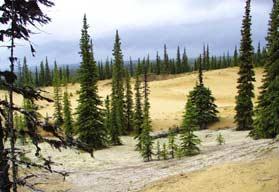
Four-hundred thousand acres of the Koyukuk Refuge are preserved as Wilderness. Miles of boreal forest surround a unique geological feature — the Nogahabara Sand Dunes. The roughly circular active dune field spans about 6 miles in diameter, and was formed thousands of years ago when wind-blown glacial sand was deposited at the base of the Nulato Hills. The isolated dunes are lightly vegetated, and continue to shift with the wind.
The Three-Day Slough area also lies within the Koyukuk Wilderness and receives some public use, primarily by moose-hunters in the fall. Fishing and hunting are allowed throughout the Refuge, subject to State and Federal regulations. Visitors should be respectful of private in-holdings within the Refuge, and hunters are asked to maintain the Native tradition of using all parts of the gifts from nature.
The Koyukuk Wilderness, like the rest of the Koyukuk Refuge, is very remote. When planning a trip, be prepared for minimal human contact outside of the villages, and consider that weather and other situations can create conditions that are life-threatening. Enjoy and respect the challenge, discovery and freedom of wildlands. Make demands on yourself, not on the environment, and leave little or no trace of your presence.