Directions
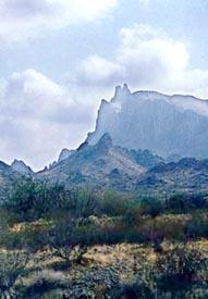
The Eagletail Mountains Wilderness is located 75 miles west of Phoenix just south of Interstate 10. It covers portions of Maricopa, La Paz, and Yuma counties.
Directions to Courthouse Rock:
From Phoenix: Take I-10 west to the Salome Road exit (#81). Turn left at the stop sign and make an immediate right onto Harquahala Valley Road and follow for 5 miles to the intersection of Centennial Road and Courthouse Road. Turn right onto Centennial Road and continue west for about 6.5 miles until reaching Pipeline Road (unmarked). Turn right onto Pipeline Road and follow it for 3.8 miles until reaching backcountry route YE013 (near the Wilderness designation sign). Turn left and park near the information kiosk.
From Quartzite: Take I-10 east to the Hovatter Road exit (#53). Turn right onto Hovatter Road. After crossing over the canal, turn left onto an unmarked dirt road. After 1 mile, turn right onto YE005. Follow YE005 until it dead-ends at Pipeline Road (unmarked). Turn left and continue until reaching the natural gas pumping station. Drive around the north side of the facility and continue east on Pipeline Road for seven miles until reaching backcountry route YE013 (near the Wilderness designation sign). Turn right and park near the information kiosk.
Due to infrequent maintenance and the wide range of road conditions that you might encounter, it is strongly recommended that high-clearance, four-wheel-drive vehicles are used for access to the Wilderness boundary.
Phone
928-317-3200
Activities
WILDERNESS
Camping Reservations
Reserve your campsite at these camping areas:
Hiking Trails
Looking for nice hiking areas to take a hike? Choose from these scenic hiking trails:
Related Link(s)
Eagletail Mountains Wilderness
Eagletail Mountains Wilderness Map
The Eagletail Mountains Wilderness (97,880 acres) in Arizona is managed by the Bureau of Land Management. In 1990, the Dos Cabezas Mountains Wilderness became part of the now over 109 million acre National Wilderness Preservation System established by the Wilderness Act of 1964. In wilderness, you can enjoy challenging recreational activities and extraordinary opportunities for solitude. Please follow the regulations in place for this area, and use Leave No Trace techniques when visiting to ensure protection of its unique natural and experiential qualities. Some lands around and within the wilderness are not federally administered. Please respect the property rights of the owners and do not cross or use these lands without their permission. Carry an ample supply of water with you since many areas have inadequate or unpurified water sources.


