Directions
From Phoenix, take I-10 west to exit 112 (Highway 85), then travel south on Hwy 85 to Gila Bend for approximately 32 miles, access I-8 east and continue for 25 miles to exit 144 (Vekol Rd).
Alternatively, take I-10 east from Phoenix to exit 164 (State Route 347). Turn right off the exit and head south on SR 347 for 28.4 miles to Hwy 84. Take Hwy 84 west for 5.6 miles to access I-8 west. Continue on I-8 west for 7.1 miles to exit 144 (Vekol Rd).
From I-8, head south on Vekol Rd, the wilderness is east of the road. Vekol Rd is maintained but can be rough or washed out. Inquire locally for conditions.
Phone
(623) 580-5500
Activities
HIKING, HORSEBACK RIDING, WILDERNESS
Camping Reservations
Reserve your campsite at these camping areas:
Hiking Trails
Looking for nice hiking areas to take a hike? Choose from these scenic hiking trails:
Related Link(s)
Overview
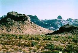
The 34,400-acre Table Top Wilderness lies in western Pinal County. Table Top Mountain is the highest peak in the area and its flat-topped summit of 4,373 ft is a familiar landmark, easily recognized from Phoenix and Casa Grande. Steeply rising flat-top mesas, ridges, lava flows, wide canyons and mesquite-and ironwood-lined washes surround Table Top Peak.
Hikers, backpackers, horseback riders and others venturing into the wilderness are rewarded with solitude. The four-mile-long Table Top Trail leads to the summit of Table Top, with the trailhead at the southwest corner of the wilderness (equestrian use not recommended on this trail due to steep conditions). The view from atop the peak provides a panorama of mountains ranges and desert plains. The abundant desert vegetation includes an unusual 40-acre island of desert grassland on the summit of Table Top and dense saguaro forests on the southwest side. The Lava Flow Trail meanders through the lowlands of the wilderness area. Desert bighorn sheep, coyote, quail, javelina, giant spotted whiptail lizard and the Ajo Mountain whipsnake, and numerous birds, reptiles and raptors abound.
Know Before You Go
- Motorized equipment and equipment used for mechanical transport are generally prohibited on all federal lands designated as wilderness. This includes the use of motor vehicles (including OHVs), motorboats, bicycles, hang gliders, wagons, carts, portage wheels, and the landing of aircraft including helicopters. Contact the agency for more information about regulations.
- Road conditions to the wilderness vary with high-clearance and four-wheel-drive vehicle requirements.
- Vekol Valley is prone to heavy rains and flash floods. Do not attempt to cross flooded washes. Wait for waters to recede before crossing.
- Fires are not allowed in Table Top Wilderness.