
Directions
Drive south from Hachita, NM, on Highway 81. Between mile 35 and 34, turn left onto County Road C11 (Hatchet Road). In about a ½ mile the road veers right. At approximately 2.1 miles, turn right on Commodore Road and follow this road approximately 3.3 miles to a T intersection. Turn right and drive approximately 1¾ miles to where the Continental Divide National Scenic Trail crosses the road. The Trail is marked by cairns; there is no trail tread. Hike southeast into the WSA.
Phone
575-525-4300
Activities
HIKING
Camping Reservations
Reserve your campsite at these camping areas:
Hiking Trails
Looking for nice hiking areas to take a hike? Choose from these scenic hiking trails:
Related Link(s)
More New Mexico Recreation Areas
BLM New Mexico YouTube Channel
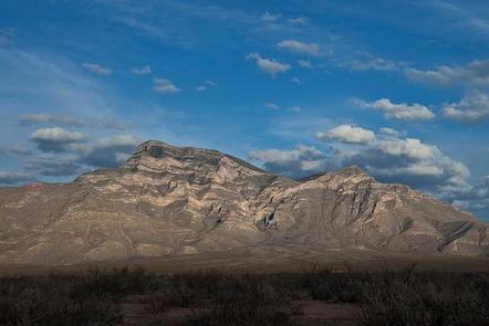
The Big Hatchet Mountains WSA is located in southwestern New Mexico and is the highest mountain in the vicinity. This is an isolated block fault uplifted mountain with tall stratified cliffs. Desert grasses and shrubs in the lowlands give way to piñon, juniper, mountain mahogany, and oak trees in the higher elevations. These mountains are very rugged and include massive limestone cliffs. These rugged mountains are home to desert bighorn sheep and significant bat colonies. The Continental Divide National Scenic Trail passes through this WSA.