
Directions
To reach Casamero Pueblo, take the Prewitt exit from Interstate 40, 19 miles west of Grants or 40 miles east of Gallup, NM. From the exit, go a few hundred feet north to the frontage road. Head east on the frontage road (Old Route 66/NM 122) for about 1/2 mile, then north on County Road 19, and continue 4 miles to a small parking area with a BLM sign on the left. A short foot trail leads to the ruins.
Phone
505-761-8700
Activities
HIKING, PHOTOGRAPHY
Camping Reservations
Reserve your campsite at these camping areas:
Hiking Trails
Looking for nice hiking areas to take a hike? Choose from these scenic hiking trails:
Related Link(s)
More New Mexico Recreation Areas
BLM New Mexico YouTube Channel
BLM New Mexico YouTube Channel
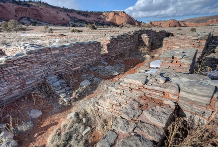
Casamero Pueblo is small Chacoan Outlier located against the majestic backdrop of the brilliant red sandstone cliffs of Tecolote (Owl) Mesa. Look for the large “owl’s eyes” that give the mesa its name. The pueblo contains 22 ground floor rooms and may have had six second-story rooms. It was occupied between A.D. 1000 and 1125 and is an excellent example of a Chacoan Outlier, with characteristic core-veneer masonry, an associated Great Kiva, and two Chacoan roads. A collection of 37 known sites is associated with Casamero and includes numerous small masonry habitation structures. A Chacoan road connects Casamero to the nearby outlier of Andrews Ranch. Foods grown and pottery produced in the Casamero community may have been traded to other outliers and to Chaco Canyon itself. Casamero was excavated between 1966 and 1967 and has since been completely stabilized so that the Chacoan masonry and the site layout are clearly visible to the public. Interpretive signs have been placed around the ruin.