Directions
La Cieneguilla Petroglyph Site is very close to the City of Santa Fe. From the intersection of Airport Road and NM 599, continue west on Airport Road for 3.3 miles. There is a gravel parking area on the west side of the road and a BLM sign. Follow a trail marked by arrows for about five to ten minutes to access the basalt cliffs where the petroglyphs are located.
Phone
575-758-8851
Activities
HISTORIC & CULTURAL SITE, HIKING
Camping Reservations
Reserve your campsite at these camping areas:
Hiking Trails
Looking for nice hiking areas to take a hike? Choose from these scenic hiking trails:
Related Link(s)
More New Mexico Recreation Areas
BLM New Mexico YouTube Channel
BLM New Mexico YouTube Channel
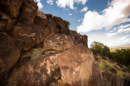
Hundreds of petroglyphs, dating from pre-contact time and the Spanish colonial era, can be found along this mesa above the Santa Fe River. Most of the petroglyphs were placed there by Keresan-speaking puebloan people living in the area between the 13th and 17th centuries. The descendants of these people now live down the Santa Fe River along the Rio Grande at the Cochiti and Santo Domingo Pueblos. The area is known for the great number of hump-backed flute player images and a great variety of bird figures. The site is also of interest to those tracing the route of El Camino Real de Tierra Adentro, as the ancient road passed along here as well.