
Directions
For access to the Bakersfield Field Office portions of this Wilderness, turn west onto 9 Mile Canyon Road from highway 395 approximately 15 miles north of Indian Wells. Follow 9 mile Canyon Road approximately 11 miles to the BLM Chimney Peak Fire Station. Sacatar Trail Wilderness encompasses most of the public lands to the east of 9 Mile Canyon Road/ Kennedy Meadow Road. There are no trailheads for this section of the Wilderness.
Phone
661-391-6000
Activities
CAMPING, HIKING, HORSEBACK RIDING, HUNTING, WILDLIFE VIEWING, PHOTOGRAPHY
Camping Reservations
Reserve your campsite at these camping areas:
Hiking Trails
Looking for nice hiking areas to take a hike? Choose from these scenic hiking trails:
Related Link(s)
More California Recreation Areas
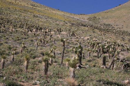
Sacatar Trail Wilderness, like Owens Peak Wilderness, includes the rugged, eastern face of the Sierra Nevada. Topography ranges from valleys, canyons, and alluvial fans to steep hills that lead into granite peaks and ridgetops reaching elevations of more than 7,800 feet. Several of the canyons are complemented by springs, which support the riparian habitats of cottonwoods, willows, and grasses. Wildlife within the area, including mule deer, golden eagles, prairie falcons, quails, and doves, can frequently be seen from hiking and horseback-riding trails. The Sacatar Trail, an old wagon road that is part of the scarce evidence of humans in this area, provides backcountry access into this wilderness.