Directions
Take I-90 (NY Thruway) to Exit 33 (Verona-Rome). Turn Right onto Rt. 365 E. Follow Rt. 365, veering left as Rt. 365 merges with Rt 69 at the fork in the road. This will take you over an arterial bridge into the City of Rome. Fort Stanwix NM will be across Erie Blvd. on the right side of James Street.
Phone
(315) 338-7730
Activities
BIKING, HISTORIC & CULTURAL SITE, HIKING, PICNICKING
Camping Reservations
Reserve your campsite at these camping areas:
Hiking Trails
Looking for nice hiking areas to take a hike? Choose from these scenic hiking trails:
Related Link(s)
More New York Recreation Areas
Fort Stanwix National Monument Official Website
Fort Stanwix National Monument Map
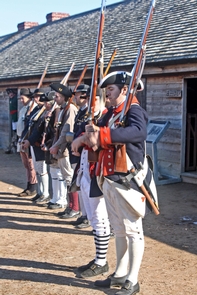
For centuries, the Oneida Carrying Place, a six mile portage connecting the Mohawk River and Wood Creek, served as a vital link for those traveling by water from the ocean to the Great Lakes. When Europeans arrived, nations fought for control of the carry, the homelands of the Six Nations Confederacy, and the rich resources of North America. In this struggle, Fort Stanwix would play a vital role.