DRY CREEK GROUP CAMPGROUND (Whiskeytown NRA), CA Campground Reservation, Info, Images, Map, Directions

DRY CREEK GROUP CAMPGROUND (Whiskeytown NRA), California Campground Images, Info & Reservations

Listen

Directions

From Interstate 5 in Redding, CA, take State Route 299 west and drive approximately 10 miles. Turn left onto Kennedy Memorial Drive at the Whiskeytown visitor center. Continue 5.6 miles on Kennedy Memorial Drive until the road ends at the access to Dry Creek Group Campground.

Phone

530-242-3412

Activities

BOATING, CAMPING, FISHING, HIKING, HORSEBACK RIDING, HUNTING, WILDLIFE VIEWING, SWIMMING, MOUNTAIN BIKING, WATER ACTIVITIES, KAYAKING, CANOEING, BIRDING, WATER ACCESS, WATER SKIING, WINDSURFING, GOLD PANNING, SAILING, SCUBA DIVING

Keywords

CG56,Whiskeytown National Recreation Area,Whiskeytown NRA

Related Link(s)

Rec Area Info & Images

California State Road Conditions

California State Tourism

Overview

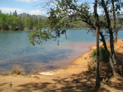
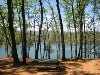
This tent-only group campground is located on the southern shore of Whiskeytown Lake in Whiskeytown National Recreation Area, 14 miles west of Redding, California and three hours north of Sacramento. The cool, clear waters of Whiskeytown Lake provide endless water activities. The picturesque mountain setting and extensive forested backcountry offer ample opportunities for hiking and biking.

Recreation

During the summer heat, swimming, kayaking, sailing, paddle boarding and water skiing are popular on the 3,200 acre lake. Year round, hiking, mountain biking, horseback riding, gold panning, fishing and picknicking attract visitors. Boats may be launched at nearby Brandy Creek Marina and moored at the campground.

Facilities

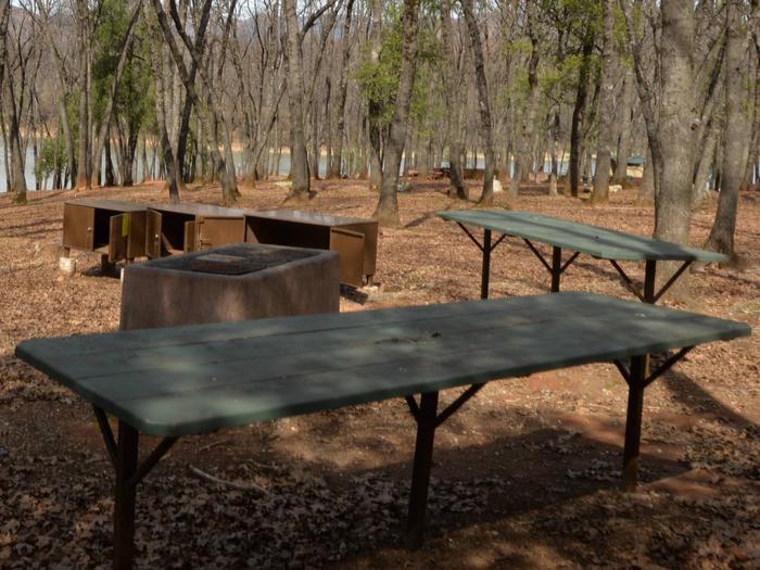
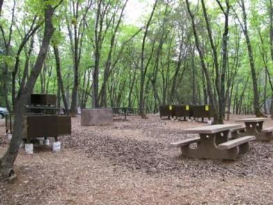
There are two spacious tent-only sites available at Dry Creek. Each site contains two large serving tables, numerous picnic tables, small and large charcoal barbecue grills, a cleared fire pit area, bear-proof storage lockers, vault toilets and drinking water.

Natural Features

Dry Creek Group Campground affords beautiful lake-side views and a canopy of conifer, oak and maple trees, which offer pleasant shade for campers. Whiskeytown Lake is located where the Klamath Mountains, Cascade and Coast Mountain Ranges, and the Sacramento Valley meet, creating a wide variety of wildlife and landscapes.

Nearby Attractions

Brandy Creek Beach is located one mile from the campground and features sandy beaches and a large swimming area. From Memorial Day through Labor Day, there are showers, a store with food and supplies and rentals of paddleboards and kayaks. The trailhead for Brandy Creek Falls is located four miles away.

Reservation

More from CampingHiking.net:

MUDDY GUARD CABIN, Wyoming Campground Images, Info & Reservations

Listen Directions From Buffalo, Wyoming, take Wyoming State Highway 16 west 24 miles. Turn left on Crazy Woman Road (FSR 33), travel 400 feet, turn right on Forest Service Road 473. Visitors will use a gate to access the cabin. Please keep the gate closed. Phone 307-684-7806 Activities BIKING, BOATING,

BRADY MOUNTAIN, Arkansas Campground Images, Info & Reservations

Listen Directions From Hot Springs, AR: Take US 270 west approximately 10 miles to Brady Mountain Access Road. Turn right and follow access road 6 miles north to the park. Phone 501-760-1146 Activities BIKING, BOATING, CAMPING, FISHING, HIKING, PICNICKING, WATER SPORTS, WILDLIFE VIEWING, DAY USE AREA, SWIMMING SITE, HOTEL/LODGE/RESORT PRIVATELY

PAYSON LAKES GUARD STATION, Utah Campground Images, Info & Reservations

Listen Directions From I-15, take exit 250 toward north Payson/Salem and proceed south on Main Street to 100 North/Highway 198. Travel east to 600 East. Turn south onto 600 East, which becomes the Nebo Loop Scenic Byway/Payson Canyon Road. Travel south along the Nebo Loop Road 015 until you see

BEAVER CREEK CABIN (MT), Montana Campground Images, Info & Reservations

Listen Directions Summer access from West Yellowstone: Proceed 8 miles north on U.S. Highway 191. Turn left onto U.S. Highway 287/Hebgen Lake Road and continue for 14.5 miles. Turn right on Beaver Creek Road/Forest Service Road 985 and drive for 3.5 miles. The cabin access road is on the right

MORGAN-CASE HOMESTEAD, Montana Campground Images, Info & Reservations

Listen Directions From Missoula, Montana, travel east on Interstate 90 for about 20 miles to exit 126. Drive south on Rock Creek Road for about 30 miles. Rock Creek Road is a hardened surface for 12 miles and the remainder is a gravel, single-lane road, with intermittent pull-outs. It is

TWIN DIKES, Texas Campground Images, Info & Reservations

Listen Directions From Jasper, TX, take US 96 north 13 miles. Go west on Recreation Rd, (FM 255) for 5 miles to the park entrance. Phone 409-384-5716 Activities BOATING, CAMPING, FISHING, HUNTING Keywords TWID,SAM RAYBURN RESERVOIR,SAM RAYBURN LAKE,TWIN DIKES PARK,SAM RAYBURN RESERVOIR Related Link(s) Rec Area Info & Images Texas