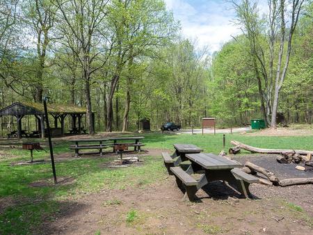
POPLAR GROVE YOUTH GROUP CAMPGROUND, MD Campground Reservation, Info, Images, Map, Directions

POPLAR GROVE YOUTH GROUP CAMPGROUND, Maryland Campground Images, Info & Reservations

Directions

Poplar Grove is located on Manahan Road in the western portion of Catoctin Mountain Park. From Route 15, exit at Catocin Mountain Park/Route 77. Travel approximately six miles west, passing the Visitor Center and Park Central Road. Turn right on Foxville-Deerfield Road and bear to the right onto Manahan Road at the fork. Poplar Grove is located about a mile ahead on the gravel road.

Phone

1 (301) 663-9388

Activities

CAMPING, HIKING, PICNICKING

Keywords

CG05,Youth Group Area,Group Camping Area,Catoctin National Park,Catoctin,Poplar,Catoctin Mountain

Related Link(s)

Rec Area Info & Images

Maryland State Tourism

Maryland State Road Conditions

Overview

Poplar Grove offers youth groups and organizations enjoyable year-round primitive tent camping. Located just steps away from the Catoctin Mountain Park portion of the Catoctin National Recreation Trail in the rolling hills of Thurmont, Maryland. Poplar Grove allows youth groups to experience traditional wilderness camping in a beautiful, natural setting.

Recreation

As a primitive camping area, Poplar Grove encourages kids to use healthy doses of imagination while surrounded by the natural landscape. Nature hikes and campfire circles are popular activities. Catoctin Mountain Park boasts 25 miles of trails for additional hiking opportunities.

Facilities

Poplar Grove allows youth to connect with nature by offering limited comforts of home. Pit toilets and drinking water are provided. Three expansive sites can accommodate up to 25 visitors each, and multiple sites may be reserved for larger groups.

Natural Features

Poplar Grove offers flat tent areas to accommodate group activities. The campground is surrounded by a rolling landscape, perfect for light hikes.

Whether blanketed in snow in winter months or blooming with wildflowers in the spring, Poplar Grove offers beautiful scenery all year. Since the site is located in a remote area, it is accessed by a gravel road during summer months, and is a hike-in only facility during winter months.

Nearby Attractions

The Catoctin Mountain Park Visitor Center is located four miles away and offers interpretive programs. Just three miles away, visitors can enjoy fishing and canoeing at Cunningham Falls State Park. Cunningham Falls charges a daily entrance fee.

Reservation

More from CampingHiking.net:

LAKES BASIN, California Campground Images, Info & Reservations

Directions In Graeagle, CA, at the intersection of State Rt. 89 and Forest Rt. 24 (Gold Lakes directional sign), turn onto Rt. 24 and go 6.9 miles to campground sign. Turn right onto the single-lane road and proceed 0.3 miles. The campground will be on the right. Phone CAMPGROUND/CAMPSITE STATUS

ALAVA BAY CABIN, Alaska Campground Images, Info & Reservations

Directions The cabin is approximately 20 air miles southeast of Ketchikan on Revillagigedo Island. Accessible by floatplane, kayak or boat with mooring buoy. Navigation is challenging due to tides, merging currents and open ocean waters. Please check tide tables in advance. Refer to USGS Ketchikan A-4. Phone 907-225-2148 Activities CAMPING,

STEVENS CREEK CAMPGROUND, Colorado Campground Images, Info & Reservations

Directions Stevens Creek campground is located off of US Hwy 50, 12 miles west of Gunnison, CO. Phone 970-641-2337 Activities BOATING, CAMPING, FISHING, HIKING, HUNTING, WATER SPORTS, WILDLIFE VIEWING, SWIMMING SITE Keywords STEC,CURECANTI NATIONAL RECREATION,CURECANTI,STEVENS Related Link(s) Rec Area Info & Images Colorado State Tourism Colorado State Road Conditions Overview

WINHALL BROOK, Vermont Campground Images, Info & Reservations

Directions From Brattleboro, Vermont, travel 30 miles north on Route 30. Turn north onto Route 100 and continue for 2.5 miles. Turn onto to Winhall Station Road and follow for a mile to the campground. From Manchester, Vermont, travel 5 miles east on Route 11. Turn right onto Route 30

PINEY POINT, Texas Campground Images, Info & Reservations

Directions From Texarkana, take Highway 59 south to Wright Patman Lake. Just south of Sulphur River Dam, turn right into the park area, following signs. Proceed one mile to the park. Piney Point is just north of Rocky Point Park. Phone 903-796-0684 Activities BOATING, CAMPING, FISHING, HIKING, WATER SPORTS Keywords

LAKE POWHATAN, North Carolina Campground Images, Info & Reservations

Directions From Asheville, take I-26 to exit 33. Go south approximately 2 miles on State Route 191 to the Lake Powhatan Recreation Area sign. Turn right and follow signs to the campground. Phone 828-552-8040 Activities BIKING, BOATING, CAMPING, INTERPRETIVE PROGRAMS, FISHING, HIKING, PICNICKING, DAY USE AREA, SWIMMING SITE, ENVIRONMENTAL EDUCATION,