
Directions
From Fresno, California, take Highway 41 north. Turn northeast on Forest Road 200 and pass through North Fork. Take Minarets Road east and follow it 37 miles. Turn right on Mammoth Pool Road and follow it 2 miles to Sweetwater Campground.
Phone
559-642-3212
Activities
BOATING, CAMPING, FISHING, HIKING, SWIMMING SITE
Keywords
SWWA,SIERRA NF – FS
Related Link(s)
California State Road Conditions
Overview
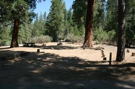
Sweetwater Campground is laid out in a single loop along Chiquito Creek, shaded by pine, oak and cedar trees. Most sites overlook the creek or a brook that also runs by the campground.
Recreation
The campground attracts visitors primarily for its fishing and swimming holes. Many recreational activities are available at Mammoth Pool, including boating, trout fishing, hiking and swimming.
Facilities
Each campsite contains a picnic table, grill and campfire ring. Vault toilets are provided. Campers must bring drinking water. Supplies are available nearby at Wagner’s Mammoth Pool Resort.
Parking spurs are dirt and paved, but tight turns and trees at the edge of interior roads make this camp most ideal for pop-up tent trailers, slide-ins and tent campers.
Natural Features
The Sierra National Forest, located on the western slope of the central Sierra Nevada, is known for its spectacular mountain scenery and abundant natural resources. The terrain includes rolling, oak-covered foothills, heavily forested middle elevation slopes and the starkly beautiful alpine landscape of the High Sierra.
Sweetwater Campground is located close to Mammoth Pool Reservoir near the Ansel Adams Wilderness. This area is known for its jagged peaks, including 13,157-foot Mt. Ritter, and numerous lakes and streams.
Nearby Attractions
A popular pastime in the area is taking a drive on the 83-mile Sierra Vista Scenic Byway.