
Directions
Access to the cabin is by float plane. It is about a 30-minute flight from Juneau. In fall, winter, and early spring, the cabin may be inaccessible due to frozen lake surface (float planes cannot land). The lake is normally ice free from mid-May through November. Refer to USGS topographic map Sitka D-2, D-3. Click here for information about reaching Forest Service Cabins.
Phone
907-586-8800
Activities
BOATING, CAMPING, FISHING, HIKING, WILDLIFE VIEWING
Keywords
EAFL,FLORENCE LAKE EAST CABIN,TONGASS NF – FS
Related Link(s)
Overview
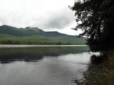
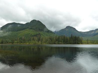
Florence Lake (East) Cabin offers guests recreation, relaxation and a unique wilderness lodging experience on the western side of Admiralty Island in the Tongass National Forest. The remote site offers a scenic setting for fishing, boating, and wildlife viewing, all within the vicinity of the cabin.
Access to the cabin is float plane only. Visitors are responsible for their own travel arrangements and safety, and must bring several of their own amenities.
Recreation
Florence Lake offers fishing for rainbow trout, Dolly Varden and northern pike. A small fishing boat with oars is provided at the cabin, however, guests need to bring their own life jackets and possibly, a small outboard (10-horsepower) motor.
Hikers may enjoy traversing a primitive 1.2-mile trail at the west end of the lake. The trail leads to a saltwater beach. Beachcombers may find Japanese fishing floats, shells, bottles, and other wave-swept treasures from the open ocean.
Facilities
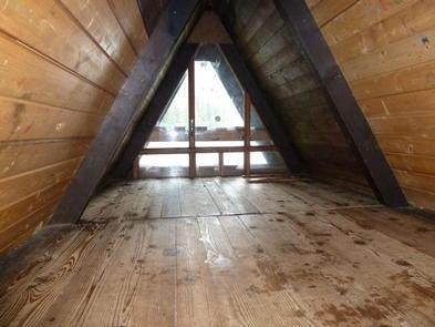
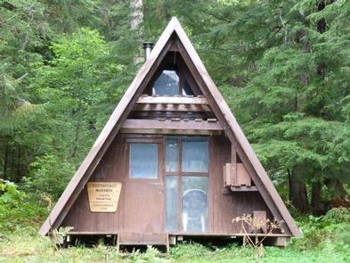
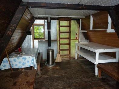
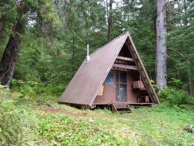
The primitive, cedar log cabin (A-frame style) has bunk beds with no mattresses and a loft, to accommodate up to seven people. It is also equipped with a table, benches, an oil stove for heat and an outside toilet. Other amenities include cooking counters, shelves, cupboard space and a broom.
The cabin does not have running water or electricity. Guests must bring their own water, food, sleeping bags, sleeping pads, cook stoves, matches, cooking gear/utensils, light source, No.1 stove oil, toilet paper, first aid kit and garbage bags, among other necessities.
Click here for more cabin details.
Natural Features
The cabin sits in a thick vegetated understory, within 150 feet of a small lakeside beach that lies beneath a canopy of old-growth forest. However, much of the surrounding area is private land and has been clear cut. Dense spruce and hemlock forests, glacier-fed streams, lakes and muskeg openings define the surrounding landscape, while rocky spires rise along the island’s high crest in the distance.
Sitka black-tailed deer stay well hidden in the dense forest but bald eagles are easily found in treetops along most beaches. Waterfowl are in abundance on the island’s many lakes, and brown bears frequent the area (learn more about bear safety).
Nearby Attractions
Bear viewing is available during the summer at Pack Creek if you obtain a permit, or in other remote bays with a little extra effort and skill. Sea kayaking is possible in Seymour Canal for those with the time and skills, or for those who employ the services of guides.
The lands surrounding the Forest Service property and cabin belong to the Shee Atika Corporation. A permit is required for any activity on corporation land. Entry without a permit will be considered trespassing and subject to legal action. The cost of the permit for noncommercial users is $25 per person, for up to 7 consecutive days. This fee-based permit was instituted by Shee Atika during the summer of 2004. To obtain a permit, call the Shee Atika office at (907) 747-3534 or toll free at 1-800-478-3534.
The forested land immediately surrounding the cabin is Forest Service land. Use of this land and the lake does not require a Shee Atika permit.