
Directions
Access to the cabin is by float plane or canoe with portage. It is about a 45-minute flight from Juneau. By canoe and portage, it is about 10 miles from Mole Harbor. Click here for for information about Admiralty Island Canoe Route and portage. This cabin is in a designated Wilderness area, and access by helicopter is illegal. In fall, winter and early spring, the cabin may be inaccessible due to frozen lake surface (float planes cannot land). Refer to USGS topographic map Sitka C-1, C-2. Click here for information about reaching Forest Service Cabins.
Inclement weather conditions may cause an extension of your trip during any time of the year and winter access can be difficult due to snow and ice conditions. Visitors should bring extra supplies to last 2-5 days. Please contact the Admiralty Island National Monument at 907-586-8800 prior to arrival for more detailed information about safety precautions.
Phone
907-586-8800
Activities
BOATING, CAMPING, FISHING, HIKING, WILDLIFE VIEWING
Keywords
LSEE,TONGASS NF – FS
Related Link(s)
Overview
Little Shaheen Cabin offers guests recreation, relaxation and a unique wilderness lodging experience in the central part of Admiralty Island in the Tongass National Forest. The remote site offers a scenic setting for hiking, fishing, canoeing and wildlife viewing, all within the vicinity of the cabin.
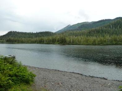
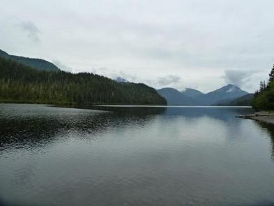
This is one of three cabins on Hasselborg Lake, which is seven miles long and part of the Admiralty Island Canoe Route.
Access to the cabin is float plane or canoe with portage. Visitors are responsible for their own travel arrangements and safety and must bring several of their own amenities.
Recreation
Anglers will find Hasselborg Lake to be a scenic setting for catching cutthroat trout, Dolly Varden and kokanee salmon. Visitors are welcome to use the skiff with oars available at the cabin and may choose to bring a small outboard motor. The motor must be less than 10 horsepower due to wilderness regulations, and visitors are responsible for bringing and using personal floatation devices. The lake is normally ice-free from mid-May through November.
Several primitive trails extend from the cabin into the forest. Big Shaheen cabin is close by, connected by a 100 yard trail. Trails accessible by boat from Hasselborg Lake go to Lake Guerin, Beaver Lake, Lake McKinney and Hasselborg River. Lake Guerin and Beaver Lake are on the Admiralty Island Canoe Route, offering guests access to pristine wilderness settings.
Facilities
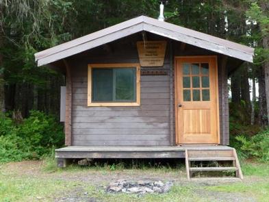
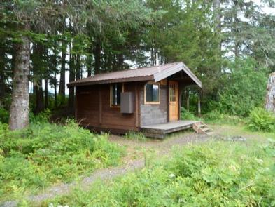
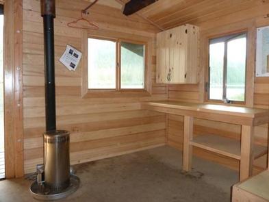
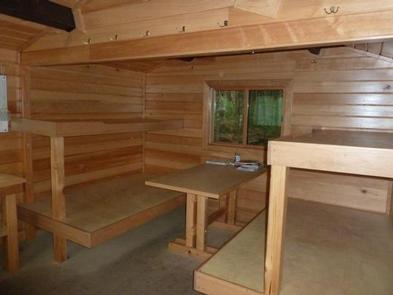
The cabin is a primitive, pre-cut cedar log cabin in pan-abode style, furnished with wooden bunkbeds without mattresses that sleep up to six guests. The cabin is equipped with a table, benches, a cooking counter, an oil stove for heat, a broom and an outside toilet.
The cabin does not have running water or electricity, and visitors must bring their own food, water, sleeping bags, sleeping pads, cook stoves, matches, cooking gear/utensils, light source, #1 stove oil, toilet paper, first aid kit and garbage bags. Water from any natural site must be filtered, boiled or chemically treated before drinking.
Guests should bring #1 heating oil (kerosene) to fuel the stove. The stove will burn half a gallon in eight hours at the lowest setting, and up to 1.2 gallons during eight hours at the highest setting. A flash light is handy for looking into the burn chamber when lighting the stove. Detailed directions with photos on how to light the stove are provided in the cabin.
Click here for more cabin details.
Natural Features
The cabin is situated under a canopy of an old growth forest of spruce and hemlock at an elevation of 300 feet, at the edge of scenic Hasselborg Lake.
The Kootznoowoo Wilderness encompasses nearly a million acres of Admiralty Island. Dense spruce and hemlock forests, glacier-fed streams, lakes and muskeg openings define the landscape, while rocky peaks tower along the island’s high crest, reaching elevations of more than 3,000 feet.
Wildlife in the area abounds. Sitka black-tailed deer find habitat in the dense forest and bald eagles perch in treetops along most beaches. Brown bear frequent the area as well. Learn more about bear safety in the Tongass National Forest.
Nearby Attractions
Admiralty Island has a rich cultural heritage, which is evident in the traditional native village of Angoon, the island’s only permanent settlement.