

Directions
Access to the cabin is by wheeled plane on the beach at low tide only, 15 minutes from Cordova. The landing area is a half-mile from the cabin. Click here for local tide information.
Inclement weather conditions may cause an extension of your trip during any time of the year and winter access can be difficult due to snow and ice conditions. Guests should bring extra supplies to last 2-5 days. Please contact the Cordova Ranger District at (907) 424-7661 prior to arrival for more detailed information about safety precautions.
Phone
1 (907) 424-7661
Activities
BOATING, CAMPING, FISHING, HIKING, HUNTING, WILDLIFE VIEWING
Keywords
HOO1,CHUGACH NF – FS
Related Link(s)
Overview
Hook Point Cabin is situated 1.5 miles west of Hook Point on Hinchinbrook Island in the Chugach National Forest. Visitors to the cabin will find many opportunities for recreation and relaxation in the vicinity. Fishing, hunting, beachcombing, hiking and wildlife viewing are all easily accessible from the site.
Access to the cabin is by wheeled plane on the beach at low tide only, 15 minutes from Cordova. The landing area is a half-mile from the cabin. Visitors are responsible for their own travel arrangements and safety, and must bring several of their own amenities.
Recreation
Hook Point Cabin has two small creeks in the area, but only one of them is fishable. Pink salmon, coho salmon and cutthroat trout are found in a creek about a mile east of the cabin.
Razor clams can provide a tasty alternative to fish. The best clamming spots may take awhile to find, but in a minus tide (0.0 feet or lower), visitors can search the shore for them (local tide tables).
There are miles of sandy beach for beachcombing. This is one of the better beaches in the spring, as winter storms wash up Japanese fishing floats, shells, bottles and other wave-swept treasures from the open ocean.
Several primitive trails extend from the cabin into the forest. A nearby waterfall makes a good day hike destination.
Hunters can take advantage of a long hunting season on the island and in the surrounding national forest. Bear season occurs during spring and fall, while deer season begins in late summer and lasts through late fall.
Facilities
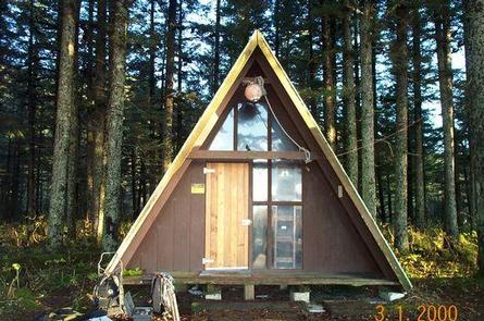
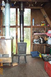
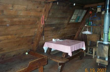
The cabin is a 16-by-16 foot rustic A-frame equipped with wooden bunks that sleep up to six guests. The cabin is furnished with a table, benches, wood and oil stoves for heat, a rainwater catchment barrel and an outdoor pit toilet.
The cabin does not have running water, electricity, cut firewood or heating oil. Visitors must bring their own water supply, firewood and #1 oil for the oil heating stove.
Visitors must bring food, sleeping bags, sleeping pads, a cook stove, matches, cooking gear, lanterns or flashlights, toilet paper, a first aid kit and garbage bags. All trash and food must be packed out, and visitors are expected to clean the cabin before leaving.
Natural Features
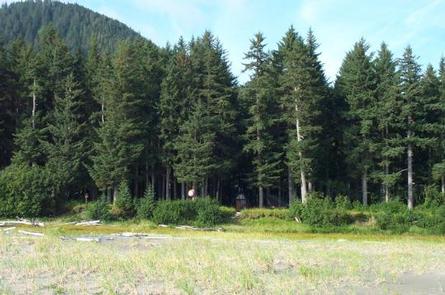
Hinchinbrook Island is in the Gulf of Alaska at the entrance to Prince William Sound. The cabin is located in a mature spruce stand at the edge of a long, sandy intertidal beach on the Gulf of Alaska side of the island. Steep mountains rise from behind the cabin.
Wildlife in the area abounds, including Sitka black-tail deer and brown bear (learn about bear safety). The beaches on the Prince William Sound shoreline offer views of the Sound and the surrounding mountains. Occasionally, humpback and killer whales can be seen spouting offshore.
Nearby Attractions
Located on the southwest end of Hinchinbrook Island, Cape Hinchinbrook Lighthouse is a fantastic historical site that has proved invaluable at directing vessels to and from Prince William Sound. Though no longer used as a primary navigational aid, the beacon still serves as a reassuring presence along the rugged Alaskan coast.