SANDY BEACH PICNIC AREA, WY Campground Reservation, Info, Images, Map, Directions

SANDY BEACH PICNIC AREA, Wyoming Campground Images, Info & Reservations

Listen

Directions

From U.S. 191 in Pinedale, Wyoming, travel north onto Skyline Drive. After 2.5 miles, turn left onto Forest Service Road 749. Follow the road to the left at the "Y" intersection, and continue for a half-mile to the entrance of Sandy Beach.

Phone

307-367-4326

Activities

BOATING, CAMPING, FISHING, SWIMMING SITE

Keywords

None

Related Link(s)

Rec Area Info & Images

Overview

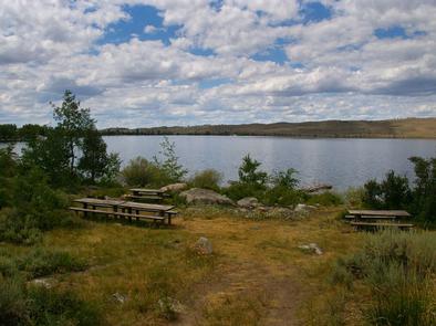
Sandy Beach Picnic Area is located on the southeast shores of pristine Fremont Lake at an elevation of 7,400 feet, just 3 miles northeast of Pinedale, Wyoming. Water sports and fishing are popular activities.

Recreation

The lake offers countless recreational activities. Anglers enjoy fishing for rainbow, brown and lake trout, as well as kokanee salmon.

Visitors also enjoy boating, sailing, canoeing, kayaking and swimming.

Facilities

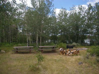
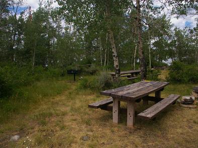
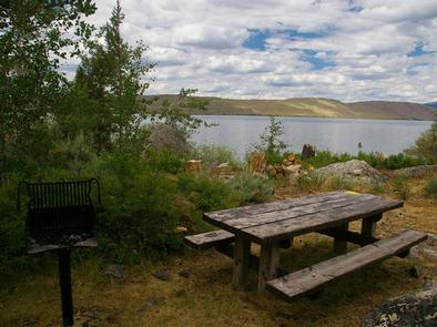
This day-use area contains one group site that can accommodate up to 75 guests. Picnic tables, grills and a fire ring with benches are provided, as are vault toilets.

A private, sandy swimming beach is on-site. A boat ramp and dock are available just outside the site. Roads and parking spurs are dirt.

Natural Features

Fremont Lake sits at the foot of the rugged Wind River Range, known for its craggy granite peaks and sparkling glacial lakes. Sandy Beach offers sweeping views of Fremont Lake, Wyoming’s second largest natural lake. Thin stands of aspens line the site, providing limited shade.

Nearby Attractions

The Museum of the Mountain Man in Pinedale features a large collection of Rocky Mountain fur trade era artifacts. Exhibits include American Indian and Mountain Man displays, as well as the history of the settlement of Sublette County, Wyoming.

Reservation

More from CampingHiking.net:

STONY CABIN, Montana Campground Images, Info & Reservations

Listen Directions From Philipsburg, travel west on Rock Creek Road/County Road 348 for approximately 14 miles, then turn right onto Rock Creek Road/County Road 102 and continue about 5 miles. Turn left at Stony Creek Road/County Road 241 and the cabin is about a quarter-mile on the right. Depending on

UP UP LOOKOUT, Montana Campground Images, Info & Reservations

Listen Directions West bound on I-90 take the Drexel Exit #25. From Drexel turn back east on I-90 to Ward Creek Exit #26. East bound on I-90 take the Ward Cr Exit #26. Proceed up the Ward Creek Rd #889, travel 3.2 miles. Turn right onto Road #3816 and travel

FALL RIVER CAMPGROUND, Oregon Campground Images, Info & Reservations

Listen Directions From Bend, OR: Travel 17.3 miles south on Hwy 97, then 12.2 miles southwest on County Road 42. Phone 541-323-1746 Activities CAMPING Keywords Related Link(s) Rec Area Info & Images Oregon State Tourism Oregon State Road Conditions Overview Fall River Campground is located along Fall River within the

MCKASKEY CREEK CG, Georgia Campground Images, Info & Reservations

Listen Directions Take I-75 N to Exit 290 (Canton/Rome/GA Hwy 20), Continue east onto GA 20; take an immediate right onto GA SPUR 20 for 2 miles, then turn left onto McKaskey Creek Road and travel 1 mile to campground. Physical Address: 358 McKaskey Creek Rd, Cartersville, GA 30121 Phone