


Directions
2019 Season Access Due to Boca Dam Closure – From Truckee, start up Highway 89 north and turn right onto Prosser Dam Road at the last roundabout. Go through neighborhood, keep right at Y and go over Prosser Dam. At next 4-way intersection, turn right onto Rd 73. At next 4-way intersection, turn right again onto Boca Road. Once you hit pavement, campground will be on the left in 0.5 miles.
Phone
530-587-3558. FOR RESERVATIONS, PLEASE CALL: 1 (877) 444-6777.
Activities
BOATING, CAMPING, FISHING, HIKING, WATER SPORTS, SWIMMING, KAYAKING
Keywords
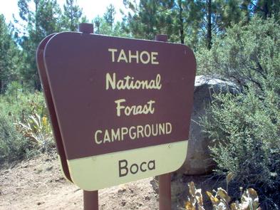
BOCA,BOCA CAMP,TAHOE NF – FS
Related Link(s)
California State Road Conditions
Overview
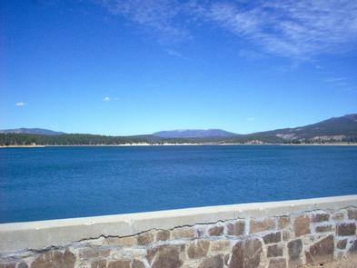
Boca Campground is located on a plateau above the shores of beautiful Boca Reservoir, 15 minutes northeast of Truckee, California. Visitors enjoy the area for its boating, swimming, and fishing opportunities. This facility is operated and maintained by the Tahoe National Forest.
Recreation
Boca Reservoir is a popular location for boating, water skiing, swimming and fishing. A boat ramp is located less than a mile from the campground. The Little Truckee River is nearby and offers some of Northern California’s best catch-and-release fly-fishing. The surrounding area offers hiking, biking, horseback riding and off-road vehicle trails. Boca Townsite Interpretive Trail showcases the boom and bust of the historic town of Boca as it transitioned from a construction camp for the Central Pacific Railroad to the Boca Mill and Ice Company and later to the Boca Brewery. It is located between Boca Dam and the railroad tracks.
Facilities
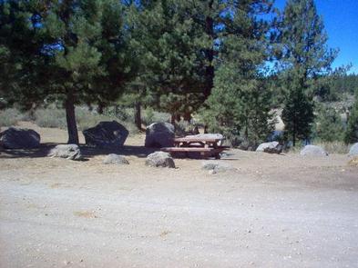
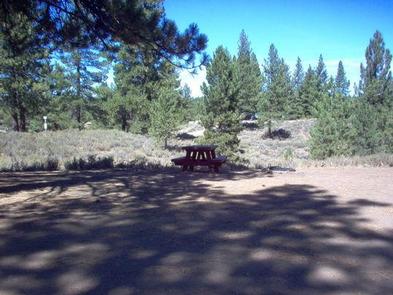
The campground offers single-family sites, a few of which are designated for tent camping only. Each site is equipped with a picnic table and campfire ring with grill. Vault toilets are provided, but there is no drinking water available.
Natural Features
The campground is located on a peninsula along the western shore of Boca Reservoir. Stands of mature Jeffrey pine and fir trees provide some shaded sites in this open campground overlooking the reservoir.
Nearby Attractions
Truckee, 15 minutes away, offers all the amenities of a year round recreational mountain town including interstate highway connectivity, top notch restaurants, resorts and hotels, grocery stores, gas stations, shopping, and historic sites. Stampede Reservoir is 12 miles north, where boating, water skiing, swimming and fishing are popular activities available. Lake Tahoe is conveniently located just 25 minutes away. Tahoe offers excellent boating, kayaking, fishing, hiking and scenic driving opportunities, as well as dining, shopping and lodging options. Other recreational opportunities in the area include Donner Camp Interpretive Trail, Overland Emigrant Commemorative Trial, Stampede Reservoir Recreation Area, Prosser Pits OHV area, and numerous hiking, mountain biking, and OHV trails.