


Directions
From Portland take 1-5 S to OR 38W, Follow US 101 to Gold Beach. From Gold Beach, Oregon, on the north end of the town , turn east off of US Highway 101 onto County Road 595 (Jerry’s Flat Road). Travel 10 miles going east on County Road 595 which becomes Forest Road 33. Turn left at 10 miles on to Forest Road 3310, cross bridge and go 10 miles. Stay to the right at the fork and turn on Forest Road 3340. Stay on this road for approximately 8.5 miles. Turn left here onto Forest Road 141 – look for the gate in this 5 road junction. Lookout is 0.75 mile up Forest Road 141 spur. Caution! Road is rough. Travel time from Gold Beach is approximately 1.5 hours on narrow, paved and gravel roads. Forest Service roads are generally one lane gravel roads with pullouts. Many people use these roads, including logging trucks and recreational vehicles. Drive slowly, stay to the right at all times, and use pullouts
Phone
541-247-3600
Activities
BIKING, CAMPING, HIKING, WILDLIFE VIEWING, MOUNTAIN BIKING, STAR GAZING
Keywords
LWLL,SISKIYOU,ROGUE RIVER,ROGUE RIVER NATIONAL FOREST,SISKIYOU NATIONAL FOREST,ROGUE RIVER-SISKIYOU NATIONAL,ROGUE RIVER SISKIYOU NATIONAL,ROGUE RIVER-SISKIYOU,ROGUE RIVER SISKIYOU,ROGUE RIVER – SISKIYOU NF – FS
Related Link(s)
Overview
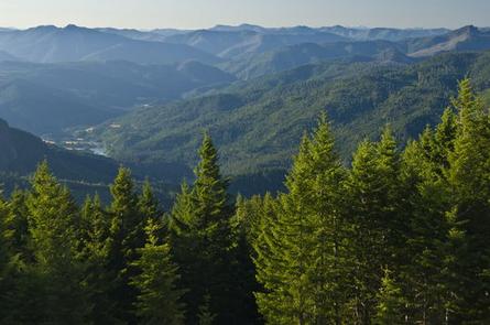
Lake of the Woods Lookout is surrounded by mountainous terrain, forested hillsides and spectacular views within the Rogue River-Siskiyou National Forest in southwestern Oregon.
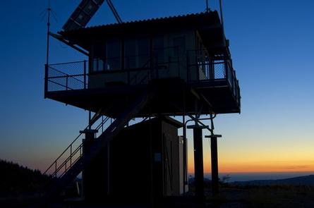
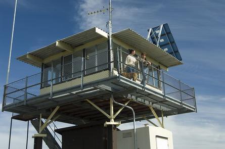
The flat-roofed cabin was originally a “ground house” located on Barklow Mountain in the Powers Ranger District. It was flown by helicopter to its present location and placed on a 12 ft. tower and catwalk in 1974. It was then staffed during fire seasons from 1974 to 1996.
The lookout offers some amenities, but guests are asked to bring a few of their own supplies to ensure a safe and comfortable stay.
Recreation
Hiking, mountain biking and stargazing are popular among guests at the lookout. Seasonal changes envelope the area as snowmelt gives rise to spring time flowers, and vivid autumn colors welcome a landscape blanketed with snow.
Logging roads and trails extend from the area, providing guests with opportunities to explore the area’s old-growth forests, rugged and steep river canyons and a variety of wildlife.
Far away from city lights, the lookout provides a fantastic opportunity for stargazing. Guests to the lookout search for constellations, planets and are treated to an occasional meteor slashing the night sky.
Facilities
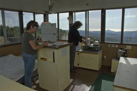
The lookout is a one-room cabin, able to accommodate up to four people. It is equipped with a double bed with a mattress, a table and two chairs, foot stool, a propane stove, propane heater and cooler, propane and solar lights, cleaning supplies and a fire extinguisher. A solar shower is provided, however, guests must provide the water.
On site, adjacent to the lookout, there is a picnic table and a campfire ring for outdoor dining. A pit toilet is also located outside the tower. There is sufficient room for one tent, but the ground is extremely rocky.
Guests to this lookout should be prepared for a rustic camping experience, and will need to bring several of their own supplies. There is no water on site, so visitors must bring a sufficient amount for drinking, cooking and washing. Guests must also provide their own sleeping bags, sleeping pads, towels, dish soap, matches, cooking gear, first aid kit, toilet paper and garbage bags.
Although lighting is provided, it is recommended guests bring an additional light source in case of emergency.
Natural Features
Lake of the Woods Lookout provides a panoramic view with vistas of the Pacific Ocean, the Kalmiopsis and Wild Rogue Wilderness areas, and the Wild and Scenic Illinois and Rogue River canyons. In the spring, the nearby Lake of the Woods, which is actually a fairly small shallow pond, is surrounded by wildflowers and welcomes the arrival of several species of birds and butterflies. As summer progresses, the lake fills in with tall reeds and grasses. Lightning storms are a part of the thrill of staying at a lookout, but they are also extremely dangerous. If a lightning storm should occur, guests are urged to follow these safety rules to minimize the danger: Stay indoors or completely inside your car If you are trapped outside during a lightning storm, move to lower ground and stay low to the ground. Do not stand under trees or other high objects. If you are in the lookout building, close the windows and doors. Lightning follows air currents: Do not touch anything metal. The Lookout has metal stairs and a metal walkway around the cabin; It is imperative guests do not stand at these locations during storms.
Nearby Attractions
Opportunities for swimming and fishing are within 10 miles of the lookout.