

Directions
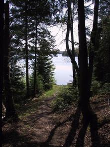
Mckeever Cabin does not have a physical address. Vehicle access from the North: Take M-28 to FH 13, which is 3 miles east of Munising. Proceed south on FH 13 for 11 miles to FR 2163, located across from the road from Widewaters Campground. Vehicle access from the South: Take US-2 to FH 13, which is about 25 miles west of Manistique. Proceed north on FH 13 for 22 miles to FR 2163. During the snow-free season: Proceed east on FR 2163 for about 1 mile, following the brown signs with yellow arrows, to the signed parking area. The non-paved trail to the cabin begins before the parking lot and is approximately 1,000 feet long. There is a sign with an arrow and the word cabin pointing down the appropriate trail. During winter season: Parking is available at the entrance to Widewaters Campground directly across from FR 2163, which is not plowed. Visitors must either snowshoe or cross-country ski for 1-mile along FR 2163 to reach the cabin. Pull behind sleds are permitted. Note: Snowmobile access to the cabin, including on the ski trail/hiking trail, is prohibited.
Phone
906-387-2512
Activities
BIKING, BOATING, CAMPING, FISHING, HUNTING, SWIMMING SITE
Keywords
MCEE,HIAWATHA NF – FS
Related Link(s)
Michigan State Road Conditions
Overview
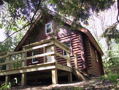
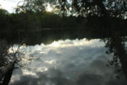
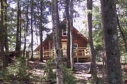
McKeever Cabin is located in the Hiawatha National Forest in Michigan’s Upper Peninsula, approximately 14 miles south of Munising, Michigan. The Cabin was constructed in 1991 and overlooks the 132-acre McKeever Lake.
While the facility offers little in the way of modern amenities, convenient access to a number of recreational activities, including hunting, fishing, hiking, mountain biking, swimming and cross-country skiing, make this cabin a desirable destination for the outdoors enthusiast.
During warmer months, visitors may park their vehicle and access the cabin by foot via a 1,000 ft. trail. When snow is present, the cabin may be accessed by snowshoe or cross-country skis via a 1-mile trail.
Recreation
During winter months, visitors can enjoy the McKeever Hills Ski Trail, which offers a quieter, less manicured alternative to highly groomed trails without sacrificing quality. The trail to the cabin connects directly to the ski trail, so visitors can ski right out the cabin door.
The Bruno’s Run Trail offers a 9 mile (14.48 km) loop ideal for hiking and mountain biking in spring, summer and fall and snow shoeing in winter. Although the trail is not groomed for cross-country skiing, it does offer a suitable source for experienced skiers who prefer to break their own way.
Seasonal activities also include swimming, canoeing, kayaking and fishing on the lake as well as hunting in designated areas. See the Michigan Department of Natural Resource’s website for information about hunting seasons and permits.
Facilities
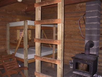
The cabin can accommodate up to four people comfortably and a maximum of six people. There are two sets of bunk beds (with 4 mattresses), one table with stools, one counter top, one corner seat and a wood burning stove. There is no longer a loft with a mattress in this cabin. There are no modern bathroom facilities or electricity offered at this cabin. In order to ensure a comfortable stay, visitors must bring several of their own supplies including a camp stove, dishes, cooking utensils, containers for carrying water, toilet paper, lanterns, sleeping bags and pillows. A vault toilet is located just off the trail to the cabin and there is a (summer/winter) hand pump with drinking water located down the trail to the lake. Do not bring firewood from home: firewood will be supplied at the cabin.
Natural Features
The cabin is situated on a small knoll surrounded by young evergreens and hardwood trees, overlooking the western shores of McKeever Lake. The lake was stocked with northern muskie in 1990, but also supports a good population of northern pike, largemouth bass, smallmouth bass and bluegill.
The Big Island Lake Wilderness is located near the cabin and features 23 small lakes ranging in size from 5 to 149 acres. White birch, maple and aspen cover the wooded hills that surround the lakes. Berries, mushrooms and wildflowers grow throughout the area and a wide range of wildlife and waterfowl, including sensitive species, may be carefully observed here.