

Directions
Note: Due to Road 17N05 being closed from damage this winter, all access must be obtained via South Fork Road and 16N02 over Ship Mountain. This route is approximately 2 hrs. one way. This is the only access to this facility at this time until road can be repaired. Approximately 18 miles of this route is not paved and has areas of washout. High clearance vehicles or 4×4 is advised. From Crescent City, head north on Highway 101 and turn right (east) on Hwy 199. Go throught the town of Hiouchi and turn right on county road 427 (South Fork Road) and continue driving 14 miles. Pavement ends and this road becomes Forest Service Road 16N02. Follow this road for 18 miles. You will see an access road (with a sign) on your left with a gate. Following the access road, it is 0.5 miles from the gate to the cabin.
Phone
707-457-3131
Activities
BIKING, CAMPING, HIKING, WINTER SPORTS, WILDLIFE VIEWING
Keywords
BRBS,SIX RIVERS NF -FS
Related Link(s)
California State Road Conditions
Overview
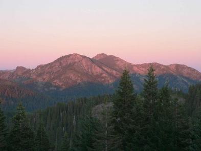
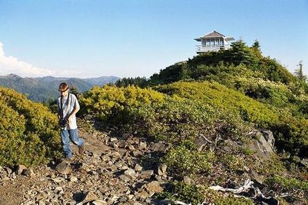
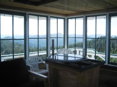
On a high, narrow mountain ridge at 5,280 feet, Bear Basin Lookout and Pierson Cabin offer visitors an awe-inspiring experience and a quiet haven away from crowds. Excellent views of the Siskiyou Wilderness to the east and the Pacific Ocean to the west are why visitors love staying in the heart of the Six Rivers National Forest of northern California.
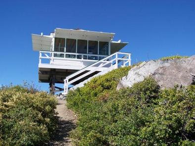
The current lookout building was previously situated at Camp Six, where it was used to spot forest fires. That structure was moved from Camp Six to Bear Basin Butte in 1996. The original Bear Basin Butte lookout existed in the 1930s.
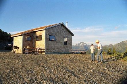
During the summer and early fall months (July 1 – September 30), the rental includes both the lookout tower and a modern 1930s-style cabin built in the 1990s.
This is a remote location. Access to the cabin is variable and the road is not maintained for winter use. High-clearance, four-wheel drive vehicles are recommended, and guests are also advised to carry chains and a shovel. Guests should note that even during the summer, the paved portion of the road (South Fork Road) frequently has numerous rocks and debris. The last half mile of the access is on a steep gravel road. Quality tires and high-clearance vehicles are recommended. Guests are responsible for their own travel arrangements and safety, and must bring several of their own amenities.
Recreation
Bird watching is available, as well as great hiking opportunities in the nearby Siskiyou Wilderness. Please don’t forget to pick up a Siskiyou Wilderness Map at your nearest Forest Service Visitor Center or local outdoor store before venturing into the wilderness. Horseback riding trails may be accessed nearby, and wildlife viewers may catch a glimpse of deer or bears, which make their home in the area.
Facilities
The lookout and cabin can accommodate up to eight guests, but up to 12 guests are permitted for an extra fee. The cabin has an entry room with a countertop suitable for organizing supplies and preparing food. Three double beds are provided (one of which is a bunk above the other) in the cabin and a futon in the lookout. The cabin also has a four-seat dining table, three chairs, a bench, a book case, and a wood-burning stove (firewood is provided).
Board games and various books may be available for use. A vault toilet, picnic tables and a campfire ring are outside. No water or electricity is available. Guests should bring plenty of water, food, bedding, flashlights and other basic camp gear (click here for more cabin details).
Nearby Attractions
The Smith River National Recreation Area Visitor Center is about 21 miles, or roughly one hour by vehicle, from the lookout.
Doe Flat and Island Lake Trailheads, which access the Siskiyou Wilderness, are within three miles of the lookout.